Ohio State Route 626

Last updated

OH-626.svg

State Route 626
OH 626 map.svg
Route information
Maintained by ODOT
Length 3.46 mi [1] (5.57 km)
Existed 1937 – present
Major junctions
South endOH-165.svg SR 165 near North Lima
North endOH-7.svg SR 7 near Boardman
Location
Counties Mahoning
Highway system
OH-625.svg SR 625 SR 627 OH-627.svg

State Route 626 (SR 626) is a northsouth state highway in the northeastern portion of the U.S. state of Ohio. The southern terminus of SR 626 is at SR 165 approximately one and a half miles (2.4 km) southeast of the hamlet of North Lima. Its northern terminus is at SR 7 nearly two miles (3.2 km) south of the township of Boardman.

A state highway, state road, or state route is usually a road that is either numbered or maintained by a sub-national state or province. A road numbered by a state or province falls below numbered national highways in the hierarchy. Roads maintained by a state or province include both nationally numbered highways and un-numbered state highways. Depending on the state, "state highway" may be used for one meaning and "state road" or "state route" for the other.

U.S. state constituent political entity of the United States

In the United States, a state is a constituent political entity, of which there are currently 50. Bound together in a political union, each state holds governmental jurisdiction over a separate and defined geographic territory and shares its sovereignty with the federal government. Due to this shared sovereignty, Americans are citizens both of the federal republic and of the state in which they reside. State citizenship and residency are flexible, and no government approval is required to move between states, except for persons restricted by certain types of court orders. Four states use the term commonwealth rather than state in their full official names.

Ohio State of the United States of America

Ohio is a Midwestern state in the Great Lakes region of the United States. Of the fifty states, it is the 34th largest by area, the seventh most populous, and the tenth most densely populated. The state's capital and largest city is Columbus.

Contents

Established in the late 1930s, State Route 626 is a two-lane highway that primarily serves local traffic in the southeastern Mahoning County municipality of Beaver Township. Along its path, SR 626 is briefly concurrent with SR 164 to cross over the Ohio Turnpike (Interstate 76 or I-76) just west of the partial interchange it has with I-680.

Mahoning County, Ohio County in the United States

Mahoning County is a county in the U.S. state of Ohio. As of the 2010 census, the population was 238,823. Its county seat is Youngstown. The county is named for an Indian word meaning "salt lick". Mahoning County was formed on March 1, 1846; the 83rd county in Ohio. Until 1846, the area that is now Mahoning County was part of Trumbull and Columbiana counties, when the counties in the area were redefined and Mahoning County emerged as a new county.

Beaver Township, Mahoning County, Ohio Township in Ohio, United States

Beaver Township is one of the fourteen townships of Mahoning County, Ohio, United States. The 2010 census found 6,711 people in the township.

Concurrency (road) instance of one physical road bearing two or more different highways

A concurrency in a road network is an instance of one physical roadway bearing two or more different route numbers. When two roadways share the same right-of-way, it is sometimes called a common section or commons. Other terminology for a concurrency includes overlap, coincidence, duplex, triplex, multiplex, dual routing or triple routing.

Route description

This state highway runs exclusively within Beaver Township in southeastern Mahoning County. SR 626 is not included within the National Highway System. [2]

National Highway System (United States) highway system in the United States

The National Highway System (NHS) is a network of strategic highways within the United States, including the Interstate Highway System and other roads serving major airports, ports, rail or truck terminals, railway stations, pipeline terminals and other strategic transport facilities. Altogether, it constitutes the largest highway system in the world.

State Route 626 begins at the intersection of SR 165 and County Road 26 (East South Range Road) approximately one and a half miles (2.4 km) southeast of North Lima. Running northwesterly from that intersection, the two-lane state route passes a number of houses, with woods abutting the roadway along the way. At Miley Road, the highway turns to the north-northwest, and passes just to the west of the partial I-680 interchange off of the Ohio Turnpike (I-76). SR 626 then bends to the northwest, and comes into a T-intersection with SR 164. Here, SR 626 turns to the northeast, and runs concurrently with SR 164 for less than 0.1 miles (0.16 km) to cross the Ohio Turnpike, then resumes its solo trek to the northwest. The route passes by a couple of commercial buildings as it departs the intersection, then travels amidst a blend of wooded terrain and open fields with scattered homes along the way. SR 626 intersects County Road 30 (East Calla Road), then continues in a northwesterly fashion, crossing railroad tracks and then passing by the Kreps Road intersection. Next, the highway passes into a more heavily residential setting, and intersects a number of side streets. Finally, SR 626 passes a couple of commercial businesses as curves to the west, passes a former alignment of the route (when it ended at a five-point signalized intersection), and ends approximately two miles (3.2 km) south of Boardman where it meets SR 7 in the community of Woodworth. [3]

History

SR 626 was created in 1937 along the routing that it currently occupies between SR 165 and SR 7. Except for a realignment away from the intersection of SR 7 and Western Reserve Road, the highway has not experienced any major changes since its inception. [4] [5]

Major intersections

The entire route is in Beaver Township, Mahoning County.

mi [1] kmDestinationsNotes
0.000.00OH-165.svgCR 26 jct.svg SR 165 (Woodsworth Road) / CR 26 (South Range Road)
1.091.75OH-164.svg SR 164 south (South Avenue)Southern end of SR 164 concurrency
1.181.90OH-164.svg SR 164 north (South Avenue)Northern end of SR 164 concurrency
3.465.57OH-7.svg SR 7 (Market Street)
1.000 mi = 1.609 km; 1.000 km = 0.621 mi

Related Research Articles

U.S. Route 224 (US 224) is a spur of US 24 that runs through the states of Indiana, Ohio and Pennsylvania. It currently runs for 289 miles (465 km) from Huntington, Indiana. at US 24 to New Castle, Pennsylvania, at US 422 Business and Pennsylvania Route 18 (PA 18). It goes through the cities of Canfield, Ohio, Akron, Ohio, and Findlay, Ohio. In Northeast Ohio, US 224 is located a short distance north of the Western Reserve's southern boundary.

Interstate 680 (I-680) in the State of Ohio is the primary Interstate Highway passing through Youngstown, Ohio. Its northern terminus is at Interstate 80 and its southern terminus is at Interstate 76, the Ohio Turnpike.

Ohio State Route 43 highway in Ohio

State Route 43 is a mainly north–south state highway that runs through the northeastern quadrant of the U.S. state of Ohio. Its southern terminus is at a signalized intersection with State Route 7 along the Ohio River in Steubenville, and its western terminus is approximately 123 miles (198 km) to the north at Public Square in Cleveland. It is one of ten routes to enter Public Square.

Ohio State Route 553 highway in Ohio

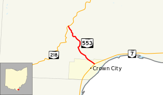
State Route 553 is a north–south state highway in the southern portion of the U.S. state of Ohio. SR 553 has its southern terminus at a T-intersection with SR 7 in Crown City. The route's northern terminus is at SR 218 approximately two miles (3.2 km) northwest of Crown City.

Ohio State Route 324 highway in Ohio

State Route 324 (SR 324) is a north–south state highway in the southern portion of the U.S. state of Ohio. The southern terminus of SR 324 is at a T-intersection with SR 160 about 4.50 miles (7.24 km) east of Hamden. Its northern terminus is at SR 93 nearly 4 miles (6.4 km) northeast of Hamden.

Ohio State Route 446 highway in Ohio

State Route 446 is an east–west state highway in the northeastern portion of the U.S. state of Ohio. The western terminus of SR 446 is at a T-intersection with U.S. Route 224 (US 224) in Canfield, approximately one mile (1.6 km) west of the downtown area. Its eastern terminus is at a Y-intersection with SR 46 about one mile (1.6 km) south of Canfield.

Ohio State Route 745 highway in Ohio

State Route 745 (SR 745) is a state route in central Ohio that runs in a north-northwesterly direction along the west bank of the Scioto River. Its southern terminus is at the concurrency of U.S. Route 33 (US 33) and SR 161 in Dublin, and it runs for approximately ten miles (16 km) to Concord Township in Delaware County, where it arrives at its northern terminus at the concurrency of US 42 and SR 257. SR 745 was designated in 1937, and its routing has not changed since.

Ohio State Route 109 highway in Ohio

State Route 109 (SR 109) is a 52.9-mile (85.1 km) state route that runs between Ottawa and the Michigan state line in the US state of Ohio. It crosses a major river, the Maumee, east of Napoleon. Most of the route is a rural two-lane highway and passes through both farmland and residential properties.

Ohio State Route 617 highway in Ohio

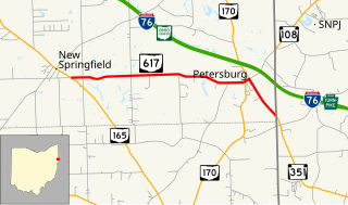
State Route 617 is a short east–west state route in northeastern Ohio, existing entirely within Springfield Township, Mahoning County. The western terminus of SR 617 is at SR 165 in the unincorporated community of New Springfield. Its eastern terminus is at the Pennsylvania State Line just southeast of the hamlet of Petersburg, where SR 617 turns into Pennsylvania Route 351 (PA 351).

Ohio State Route 546 highway in Ohio

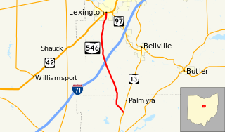
State Route 546 is a north–south state highway in the northern portion of the U.S. state of Ohio. The southern terminus of SR 546 is at a T-intersection with SR 13 nearly two and a half miles (4.0 km) north of Fredericktown. Its northern terminus is at a signalized intersection with the U.S. Route 42 (US 42)/SR 97 concurrency in Lexington.

In the U.S. state of Ohio, Interstate 76 (I-76) runs for 82 miles (132 km) from Interstate 71 south of Cleveland to the Pennsylvania state line south of Youngstown. Once numbered Interstate 80S, Interstate 76 now comprises the easternmost leg of the Ohio Turnpike.

Ohio State Route 164 highway in Ohio

State Route 164 (SR 164) is a state highway passing through four counties in east-central Ohio. The route runs in a general southwest to northeast fashion, and is signed north–south accordingly. The southern terminus is at an intersection with State Route 212 1-mile (1.6 km) south of Leesville, and the northern terminus is at Interstate 680 and Western Reserve Road on the Beaver and Boardman township boundary between North Lima and Boardman. The southern part of the route serves more rural areas while it makes its way through larger villages and cities toward its northern end.

Ohio State Route 630 highway in Ohio

State Route 630 (SR 630) is a 2.56-mile-long (4.12 km) east–west state highway in the northeastern quadrant of the U.S. state of Ohio. The western terminus of SR 630 is at a signalized intersection with SR 170 in the northern end of the village of New Middletown. Its eastern terminus is at the Pennsylvania state line nearly two miles (3.2 km) east of New Middletown. Upon crossing the border, SR 630 becomes Pennsylvania Route 317 (PA 317), which continues east to Bessemer.

Ohio State Route 625 highway in Ohio

State Route 625 is a state route in northeastern Ohio that exists entirely within Mahoning County. The southern terminus of SR 625 is at U.S. Route 224 (US 224) near Boardman, and its northern terminus is at US 62 in the southwestern portion of Youngstown. SR 625 is currently signed north–south, but in the past was signed east–west.

Ohio State Route 644 highway in Ohio

State Route 644 is a north–south state highway running through Columbiana and Carroll counties in northeast Ohio. Its southern terminus is at SR 39 in downtown Salineville, and its northern terminus is at its junction with U.S. Route 30(US 30) and SR 9 in the center of Kensington. The route connects mainly rural and a few unincorporated parts of southeastern Columbiana County. SR 644 only briefly passes into a corner of Carroll County for a 0.41-mile (0.66 km) journey.

Ohio State Route 691 highway in Ohio

Ohio State Route 691 is a north–south state route in southern Ohio. The entirety of SR 691 is within Athens County. Its southern terminus is at OH 56 about 1.5 miles (2.4 km) northwest of New Marshfield, and its northern terminus is at an interchange with US 33 and SR 78 in Nelsonville.

Ohio State Route 748 highway in Ohio

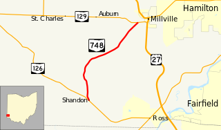
State Route 748 is a north–south state highway in southwestern Ohio, a U.S. state. Situated in west-central Butler County, SR 748 has its southern terminus at SR 126 in the unincorporated community of Shandon. Its northern terminus is at SR 129 near Millville, just one-half mile (0.80 km) west of SR 129's junction with U.S. Route 27.

Ohio State Route 187 highway in Ohio

State Route 187 (SR 187) is a 8.22-mile (13.23 km) north–south state highway in the central portion of the U.S. state of Ohio. The southern terminus of SR 187 is at a T-intersection with SR 56 approximately 4.25 miles (6.84 km) northwest of London. Its northern terminus is at a T-intersection with SR 29 about one mile (1.6 km) to the southeast of Mechanicsburg.

Ohio State Route 312 highway in Ohio

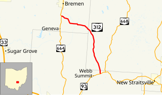
State Route 312 (SR 312) is a north–south state highway located in the southern portion of the U.S. state of Ohio. SR 312 runs from its southern terminus at a T-intersection with SR 93 approximately 4.25 miles (6.84 km) northeast of Logan to its northern terminus at a T-intersection with SR 664 nearly 1.25 miles (2.01 km) south of Bremen.

Ohio State Route 524

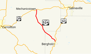
State Route 524 is a state highway in eastern Ohio. The 8.10-mile-long (13.04 km) north–south route runs from the village of Bergholz at SR 164 to the unincorporated community of Mechanicstown at SR 39.

References

  1. 1 2 "DESTAPE - Mahoning County" (PDF). Ohio Department of Transportation. June 24, 2015. Retrieved November 5, 2015.
  2. National Highway System: Ohio (PDF) (Map). Federal Highway Administration. December 2003. Retrieved 2010-09-21.
  3. Google (November 5, 2015). "Ohio State Route 626" (Map). Google Maps . Google. Retrieved November 5, 2015.
  4. Ohio State Map (Map). Ohio Department of Transportation. 1936.
  5. Ohio State Map (Map). Ohio Department of Transportation. 1937.

Route map: Google

KML file (edithelp)
KML is from Wikidata