Description
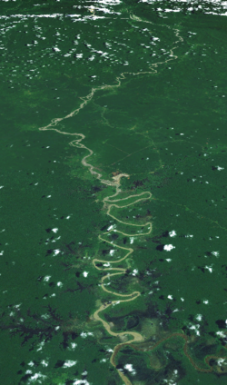
Known as the Ok Tedi River by the Yonggom people who live on its western bank, it was renamed the Alice River by the Italian explorer Luigi d'Albertis. [1] Ok is the word for water or river in the Ok languages family. It is a tributary of the Fly River. Tributaries of the Ok Tedi include the Birim.
The Kiunga-Tabubil Highway runs parallel with the river for the majority of its course, until just south of Ningerum where the highway veers southeast towards Kiunga, a port town on the Fly River.
The river is extremely fast-moving and has a massive capacity. It is situated on a sand bank, which allows for the river to change course quickly without warning. The sand conditions underneath the river and the extremely high rainfall of the catchment area make it one of the fastest moving rivers in the world. The roar from the river can be heard for many kilometres through the dense jungle of the district.
The pristine river was devastated by the Ok Tedi environmental disaster, an enormous open pit copper/gold mine which discharges waste directly into the river. Until its recent seizure by the Papua New Guinea government the mine was owned by BHP Billiton, an Anglo-Australian multinational mining, metals and petroleum company headquartered in Melbourne, Australia. It is the world's largest mining company measured by 2013 revenues.
The Wopkaimin are a small aboriginal tribe that lives in the remote Star Mountains in western Papua New Guinea in what is known as the Fly River socio-ecological region. The tribe speaks Faiwol.

The Fly River is the third longest river in the island of New Guinea, after the Sepik River and Mamberamo River with a total length of 1,060 km (660 mi) and the largest by volume of discharge in Oceania, the largest in the world without a single dam in its catchment, and overall the 25th-largest primary river in the world by discharge volume. It is located in the southwest of Papua New Guinea and Papua Province of Indonesia. It rises in the Victor Emanuel Range arm of the Star Mountains, and crosses the south-western lowlands before flowing into the Gulf of Papua in a large delta.
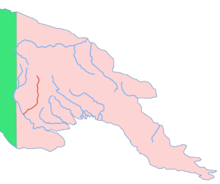
The Strickland River is a major river in the Western Province of Papua New Guinea. It is the largest tributary of the Fly River with a total length of 824 km (512 mi) including the Lagaip River the main river source of the Strickland River. It was named after Edward Strickland, vice-president of the Geographical Society of Australasia by the New Guinea Exploration Expedition of 1885.

Western Province is a coastal province in southwestern Papua New Guinea, bordering the Indonesian province of Papua. The provincial capital is Daru. The largest town in the province is Tabubil. Other major settlements are Kiunga, Ningerum, Olsobip and Balimo.

Mount Hagen is the third largest city in Papua New Guinea, with a population of 46,250. It is the capital of the Western Highlands Province and is located in the large fertile Wahgi Valley in central mainland Papua New Guinea, at an elevation of 1,677 m (5,502 ft).

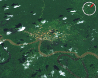
Tabubil is a town located in the Star Mountains area of the North Fly District of Western Province, Papua New Guinea. The town, including the adjoining relocated village of Wangabin and the industrial area of Laydown, is the largest settlement in the province, although the provincial capital, Daru is a similar size. It had a recorded population of 10,270 at the 2011 census.

The Ok Tedi Mine is an open-pit copper and gold mine in Papua New Guinea located near the headwaters of the Ok Tedi River, in the Star Mountains Rural LLG of the North Fly District of the Western Province of Papua New Guinea.
Kiunga is a port town on the Fly River in the Western Province of Papua New Guinea, just upstream from the D'Albertis Junction with the Ok Tedi River. It is the southernmost terminus of the Kiunga-Tabubil Highway. Local industry rests on a cornerstone of freight and haulage, particularly from the Ok Tedi Mine and provisioning for the much larger town of Tabubil. Natural rubber has been an emerging industry more recently, with a processing/manufacturing plant being built in town.
Tabubil Airport is an international airport in Tabubil, Papua New Guinea. Asia Pacific Airlines operates out of Tabubil as its hub.

Ok Tedi Mining Limited is a Papua New Guinean company that administers the Ok Tedi Mine in the northern part of the Western Province. Its main office is located in Tabubil and the building is known as the White House. Its chairman, since 2014, has been former Deputy Prime Minister Moi Avei.
The Ok Tedi environmental disaster caused severe harm to the environment along 1,000 km (620 mi) of the Ok Tedi River and the Fly River in the Western Province of Papua New Guinea between around 1984 and 2013. The lives of 50,000 people have been disrupted. One of the worst environmental disasters caused by humans, it is a consequence of the discharge of about two billion tons of untreated mining waste into the Ok Tedi from the Ok Tedi Mine, an open pit mine situated in the province.

The Kiunga-Tabubil Highway is an all-weather gravel road that runs from the river port town of Kiunga through Ningerum and Tabubil to the Ok Tedi Mine site, in the remote North Fly District of the Western Province of Papua New Guinea. The road is around 137 kilometres (85 mi) long, but this changes as sections are rehashed.
Mining in Papua New Guinea is an important part of the Papua New Guinea economy.
Mount Fubilan was a mountain in the Western Province of Papua New Guinea. It has been removed in the course of the excavation of the Ok Tedi Mine, which been developed since 1984 as an open-pit copper and gold mine. After decades of mining, the mountain has been replaced by a massive pit in the ground.

The North Fly District of the Western Province of Papua New Guinea is the northernmost, smallest, and arguably the most remote of the three districts of the province. It contains the Local-Level Government (LLG) areas of Kiunga Rural, Kiunga Urban, Ningerum Rural, Olsobip Rural and Star Mountains Rural, and the townships of Kiunga, Tabubil, Olsobip and Ningerum.

The Middle Fly District of the Western Province of Papua New Guinea is a large, coastal district that forms the central area of the Fly River basin. It contains the Local-Level Government areas of: Balimo Urban, Bamu Rural, Gogodaia Rural, Lake Murray Rural, and Nomad Rural, and the population centres of Balimo, Bamu, Gogodala and Nomad. It also contains the largest lake in the country, Lake Murray.
The glass blue-eye is a species of fish in the subfamily Pseudomugilinae. It is endemic to Papua New Guinea where it is only known to occur in a few small creeks adjacent to a 15–20 kilometres (9.3–12.4 mi) stretch of the Ok Tedi Mine supply road between the settlements of Kiunga and Tabubil in the Upper Fly River system close to the frontier with Irian Jaya. This species has a mainly transparent body with silvery gill covers and belly, there are black spots on the margins of the scales and there are black markings on the fins and lateral line, with the fins being shaded with yellow, with the exception of the transparent pectoral fins. It attains a standard length of 3 centimetres (1.2 in).This species was described by Gerald R. Allen in 1983 and its specific name honours the site biologist at the Ok Tedi Mine, David Balloch, for the support and assistance he gave Allen.
Boka Kondra is a Papua New Guinea politician. He was a member of the National Parliament of Papua New Guinea from July 2007 until December 2016, representing the electorate of North Fly Open, variously as an independent, for the National Alliance and for the People's National Congress. He was Vice-Minister for Mining (2011-2012) and Minister for Tourism, Arts and Culture (2012-2016) in the O'Neill government. Kondra was dismissed from office in December 2016 after a leadership tribunal found him guilty of misappropriation charges.
The Birim River or Ok Birim in the western province of New Guinea is a tributary of the Ok Tedi River, which is in turn a tributary of the north Fly River. The Birim river joins the Ok Tedi river from the west between Ningerum and Bige. The Birim river area is inhabited by the Yonggom tribe. They practise tropical forest Swidden agriculture. About 3,000 people, they speak the Ninggerum language of the Ok group.
Samantha Maria Andreas is an environmental chemist and occupational health and safety expert in the mining industry of Papua New Guinea. She was the inaugural Young Achiever awardee from the first year of the Westpac Women in Business Awards, and is also a recipient of the Chevening Scholarships to study in the United Kingdom.