Brea is a city in northern Orange County, California. The population as of the 2010 census was 39,282. It is 33 miles (53 km) southeast of Los Angeles. Brea is part of the Los Angeles metropolitan area.

Fullerton is a city located in northern Orange County, California, United States. As of the 2020 census, the city had a total population of 143,617.

Pacific Palisades is a neighborhood in the Westside region of Los Angeles, California, situated about 20 miles (32 km) west of Downtown Los Angeles.

Chino Hills State Park is a state park of California, in the United States. It is located in the Chino Hills, foothills of the Santa Ana Mountains. It is a critical link in the Chino–Puente Hills wildlife corridor, and a major botanical habitat reserve for resident and migrating wildlife.

West Hills is an affluent suburban / residential community in the western San Fernando Valley region of the City of Los Angeles, California. The percentage of residents aged 35 and older is among the highest in Los Angeles County.

Baldwin Hills is a neighborhood within the South Los Angeles region of Los Angeles, California. It is home to Kenneth Hahn State Regional Park and to Village Green, a National Historic Landmark.

The Puente Hills are a chain of hills, one of the lower Transverse Ranges, in an unincorporated area in eastern Los Angeles County, California, in the United States. The western end of the range is often referred to locally as the Whittier Hills.

Brea Olinda High School is a 9th–12th grade public high school located in Brea, California. Established in 1927, the school was originally located across the street from the Brea Mall. In 1989, the school moved to its current location on the northern hills of Brea. Brea Olinda High School is a part of the Brea Olinda Unified School District.

Hancock Park is a city park in the Miracle Mile section of the Mid-Wilshire neighborhood in Los Angeles, California.
Silverado is an unincorporated community in Silverado Canyon, which is located in the Santa Ana Mountains in eastern Orange County, California. Portions of the town sit on a former Mexican land grant Rancho Lomas de Santiago. Silverado is located at the boundaries of Cleveland National Forest. The site is a California Historical Landmark, and is located near the village site of Puhú.

Brea Olinda Unified School District is the school district serving the City of Brea in Orange County, California, United States. It also serves portions of the nearby cities of Fullerton, Yorba Linda and La Habra.

Mentryville was an oil drilling town in the Santa Susana Mountains in Los Angeles County, California, USA. It was started by Charles Alexander Mentry in the 1870s around the newly discovered oil reserves in that area. The first oil strike was on September 26, 1876. The town is located at the terminus of Pico Canyon Road, four miles west of the Lyons Avenue exit from I-5 in Santa Clarita. It is currently a part of Stevenson Ranch.

Village Green, originally named Baldwin Hills Village, is a neighborhood at the foot of Baldwin Hills, within the city of Los Angeles, California. Village Green consists of a large condominium complex that is both a Los Angeles Historic-Cultural Monument and a National Historic Landmark. Designed in the late 1930s and built out by 1942, it is one of the oldest planned communities of its type in the nation. Village Green was named by The American Institute of Architects as one of the 100 most important architectural achievements in U.S. history.

Brea City Hall Park, in Brea, California, was listed on the National Register of Historic Places in 1984.
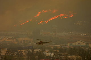
The Freeway Complex Fire was a 2008 wildfire in the Santa Ana Canyon area of Orange County, California. The fire started as two separate fires on November 15, 2008. The Freeway Fire started first shortly after 9am with the Landfill Fire igniting approximately 2 hours later. These two separate fires merged a day later and ultimately destroyed 314 residences in Anaheim Hills and Yorba Linda.

Placerita Canyon State Park is a California State Park located on the north slope of the western San Gabriel Mountains, in an unincorporated rural area of Los Angeles County, near the city of Santa Clarita. The park hosts a variety of historic and natural sites, as well as serving as a trailhead for several hiking trails leading into the San Gabriel Mountains.
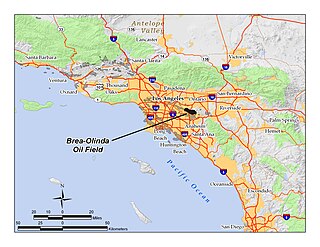
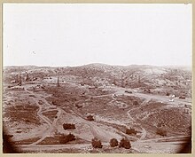
The Brea-Olinda Oil Field is a large oil field in northern Orange County and Los Angeles County, California, along the southern edge of the Puente Hills, about four miles (6 km) northeast of Fullerton, and adjacent to the city of Brea. Discovered in 1880, the field is the sixteenth largest in California by cumulative production, and was the first of California's largest 50 oil fields to be found. It has produced over 412 million barrels of oil in the 130 years since it was first drilled, and retains approximately 19 million barrels in reserve recoverable with current technology. As of the beginning of 2009, 475 wells remained active on the field, operated by several independent oil companies, including Linn Energy, BreitBurn Energy Partners L.P., Cooper & Brain, and Thompson Energy.
The Olinda Landfill is a landfill situated in Orange County, California, west of the northern portion of Chino Hills State Park in Carbon Canyon in Olinda neighborhood of Brea City.

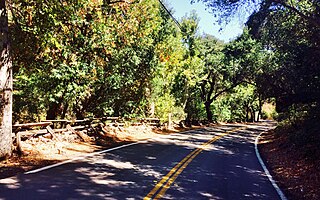
Carbon Canyon Regional Park is a regional park in Brea, California, that was created after the Carbon Canyon Creek was dammed. It links up with Chino Hills State Park on the east side. The park also is home to a small forest of Redwood trees, which have been struggling to survive since the start of the 2010 California drought.

Olinda Elementary is an elementary-level school located in Brea, California.