Related Research Articles

Brea is a city in northern Orange County, California. The population as of the 2010 census was 39,282. It is 33 miles (53 km) southeast of Los Angeles. Brea is part of the Los Angeles metropolitan area.

Chino Hills is a city located in the southwestern corner of San Bernardino County, California, United States. The city borders Los Angeles County on its northwest side, Orange County to its south and southwest, and Riverside County to its southeast.

Chino Hills State Park is a state park of California, in the United States. It is located in the Chino Hills, foothills of the Santa Ana Mountains. It is a critical link in the Chino–Puente Hills wildlife corridor, and a major botanical habitat reserve for resident and migrating wildlife.
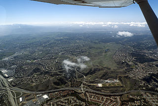
The Chino Hills are a mountain range on the border of Orange, Los Angeles, and San Bernardino counties, California, with a small portion in Riverside County. The Chino Hills State Park preserves open space and habitat in them.

Area codes 714 and 657 are telephone area codes in the North American Numbering Plan for the southern part of the U.S. state of California. The numbering plan area comprises northern Orange County, a portion of Los Angeles County, and the Sleepy Hollow and Carbon Canyon areas of Chino Hills in San Bernardino County. Area code 714 was assigned to a part of numbering plan area 213 in 1951, and 657 was added in 2008 to form an overlay complex.

The Puente Hills are a chain of hills, one of the lower Transverse Ranges, in an unincorporated area in eastern Los Angeles County, California, in the United States. The western end of the range is often referred to locally as the Whittier Hills.

State Route 142, also known as Carbon Canyon Road for most of its length, is a state highway in the U.S. state of California that connects Brea in Orange County with Chino Hills in San Bernardino County. The eastern portion of the route is known as Chino Hills Parkway.
California's 40th congressional district is a congressional district in the U.S. state of California, encompassing Orange, San Bernardino, and Riverside counties. The district is currently represented by Republican Young Kim. It was one of 18 districts that would have voted for Joe Biden in the 2020 presidential election had they existed in their current configuration while being won or held by a Republican in 2022.
Brea Olinda Unified School District is the school district serving the City of Brea in Orange County, California, United States. It also serves portions of the nearby cities of Fullerton, Yorba Linda and La Habra.

Puente Hills Landfill was the largest landfill in the United States, rising 500 feet high and covering 700 acres (2.8 km2). Originally opened in 1957 in a back canyon in the Puente Hills, the landfill was made to meet the demands of urbanization and waste-disposal east of Los Angeles. By the 1990s, the landfill became an artificial mountain visible around the San Gabriel Valley region. Puente Hills accepted four million tons of waste in 2005. As of October 31, 2013, its operating permit was terminated and it no longer accepts new refuse. The former landfill is in the process of becoming a natural habitat preservation area.

Olinda is a neighborhood in Brea, California, located on Carbon Canyon Road east of the rest of the city. The original village was founded in the 1890s and grew when petroleum was discovered at the adjacent Brea-Olinda Oil Field. In February 1917, Olinda Village and the nearby town of Randolph were incorporated as the city of Brea. The site is now registered as California Historical Landmark #918 registered on January 1. 1978.
The California Department of Resources Recycling and Recovery is a branch of the California Environmental Protection Agency that oversees the state's waste management, recycling, and waste reduction programs. CalRecycle was established in 2010 to replace the California Integrated Waste Management Board. It is known for administering the California Redemption Value (CRV) program, among other responsibilities.

The Freeway Complex Fire was a 2008 wildfire in the Santa Ana Canyon area of Orange County, California. The fire started as two separate fires on November 15, 2008. The Freeway Fire started first shortly after 9 am with the Landfill Fire igniting approximately 2 hours later. These two separate fires merged a day later and ultimately destroyed 314 residences in Anaheim Hills and Yorba Linda.

Coyote Creek is a principal tributary of the San Gabriel River in northwest Orange County, southeast Los Angeles County, and southwest Riverside County, California. It drains a land area of roughly 41.3 square miles (107 km2) covering eight major cities, including Brea, Buena Park, Fullerton, Hawaiian Gardens, La Habra, Lakewood, La Palma, and Long Beach. Some major tributaries of the creek in the highly urbanized watershed include Brea Creek, Fullerton Creek, and Carbon Creek. The mostly flat creek basin is separated by a series of low mountains, and is bounded by several small mountain ranges, including the Chino Hills, Puente Hills, and West Coyote Hills.
Pasinogna is a former Tongva-Gabrieleño Native American settlement in San Bernardino County, California.
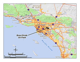
The Brea-Olinda Oil Field is a large oil field in northern Orange County and Los Angeles County, California, along the southern edge of the Puente Hills, about four miles (6 km) northeast of Fullerton, and adjacent to the city of Brea. Discovered in 1880, the field is the sixteenth largest in California by cumulative production, and was the first of California's largest 50 oil fields to be found. It has produced over 412 million barrels of oil in the 130 years since it was first drilled, and retains approximately 19 million barrels in reserve recoverable with current technology. As of the beginning of 2009, 475 wells remained active on the field, operated by several independent oil companies, including Linn Energy, BreitBurn Energy Partners L.P., Cooper & Brain, and Thompson Energy.

Carbon Canyon Dam is a dam at the northern edge of Orange County, California. The dam is approximately 4 miles (6.4 km) east of the city of Brea and approximately 12 miles (19 km) north of the city of Santa Ana. The drainage area above the dam is 19.3 square miles (50 km2) and is encompassed entirely within the Puente and Chino Hills. The Carbon Canyon Creek flows in a generally southwesterly direction onto the coastal Orange County Plain, joins Coyote Creek, and then flows into the San Gabriel River.
The San Francisco Mandatory Recycling and Composting Ordinance is a local municipal ordinance requiring all persons located in San Francisco to separate their recyclables, compostables and landfilled trash and to participate in recycling and composting programs. Passed by the San Francisco Board of Supervisors in 2009, it became the first local municipal ordinance in the United States to universally require source separation of all organic material, including food residuals.

Carbon Canyon Regional Park is a regional park in Brea, California, that was created after the Carbon Canyon Creek was dammed. It links up with Chino Hills State Park on the east side. The park also is home to a small forest of Redwood trees, which have been struggling to survive since the start of the 2010 California drought.
References
- ↑ California Department of Resources Recycling and Recovery (CalRecycle). "Olinda Landfill at CalRecycle". Archived from the original on 2010-08-03. Retrieved 2010-12-30.
- 1 2 3 Hills For Everyone - Friends of Puente-Chino Hills Wildlife Corridor. "Olinda Landfill at Hills For Everyone". Archived from the original on 2011-07-26. Retrieved 2010-12-30.
- 1 2 3 Orange County Waste & Recycling Department. "Olinda Landfill at Orange County Waste & Recycling Department". Archived from the original on 2010-07-03. Retrieved 2010-12-30.
- 1 2 Carbon Canyon Chronicle. "Olinda Landfill at Carbon Canyon Chronicle" . Retrieved 2010-12-30.