Olney Springs, Colorado

Last updated

Olney Springs, Colorado
Olney Springs, Colorado.JPG
Olney Springs' town hall and welcome sign.
Crowley County Colorado Incorporated and Unincorporated areas Olney Springs Highlighted 0855705.svg
Location of Olney Springs in Crowley County, Colorado.
Coordinates: 38°9′57″N103°56′45″W / 38.16583°N 103.94583°W / 38.16583; -103.94583
Country Flag of the United States (23px).png  United States
State Flag of Colorado.svg  Colorado
County [1] Crowley
Incorporated (town) May 27, 1912 [2]
Government
  Type Statutory Town [1]
Area
[3]
  Total0.24 sq mi (0.62 km2)
  Land0.24 sq mi (0.62 km2)
  Water0.00 sq mi (0.00 km2)
Elevation
[4]
4,383 ft (1,336 m)
Population
 (2020) [5]
  Total315
  Density1,300/sq mi (510/km2)
Time zone UTC-7 (Mountain (MST))
  Summer (DST) UTC-6 (MDT)
ZIP code [6]
81062
Area code 719
FIPS code 08-55705
GNIS feature ID 0195368
Website townofolneysprings.colorado.gov

Olney Springs is a Statutory Town in Crowley County, Colorado, United States. The population was 315 at the 2020 census. [5]

Contents

Description

A post office called Olney Springs has been in operation since 1909. [7] The town was named after one Mr. Olney, a railroad official. [8]

Geography

Olney Springs photographed from above in 1937 by the Soil Conservation Service. AG 274-55 - DPLA - a8054af7500c67f4bef77bc0058486a6.jpg
Olney Springs photographed from above in 1937 by the Soil Conservation Service.

Olney Springs is located in southwestern Crowley County at 38°9′57″N103°56′45″W / 38.16583°N 103.94583°W / 38.16583; -103.94583 (38.165844, -103.945723). [9] Colorado State Highway 96 leads east 11 miles (18 km) to Ordway, the county seat, and west 38 miles (61 km) to Pueblo.

According to the United States Census Bureau, the town has a total area of 0.2 square miles (0.52 km2), all of it land.

Slightly west of the town is the Crowley County Correctional Facility, owned by the Corrections Corporation of America. It has 1,794 prisoners from various states. Built as a speculative venture in 1998, it had a massive riot in 1999 when operated by the now-defunct Community Services Corporation. The builder, Dominion Ventures, took over its management, and in January 2003 ownership and operation transferred to CCA. Another devastating riot took place on July 20, 2004, once again requiring massive intervention by local and state law enforcement and correctional personnel. [10]

Demographics

Historical population
CensusPop.Note
1920 240
1930 228−5.0%
1940 26014.0%
1950 2797.3%
1960 263−5.7%
1970 2640.4%
1980 253−4.2%
1990 34034.4%
2000 38914.4%
2010 345−11.3%
2020 315−8.7%
U.S. Decennial Census

See also

Related Research Articles

<span class="mw-page-title-main">Crowley County, Colorado</span> County in Colorado, United States

Crowley County is a county in Colorado. As of the 2020 census, the population was 5,922. The county seat is Ordway. It is also the poorest county in the country, with a per capita personal income of $22,240.

<span class="mw-page-title-main">Vilas, Colorado</span> Town in Colorado, United States

Vilas is a statutory town located in Baca County, Colorado, United States. The population was 98 at the 2020 census.

<span class="mw-page-title-main">Crowley, Colorado</span> Town in Crowley County, Colorado, United States

The Town of Crowley is a Statutory Town in Crowley County, Colorado, United States. The town population was 166 at the 2020 United States Census.

<span class="mw-page-title-main">Ordway, Colorado</span> Town in and county seat of Crowley County, Colorado, United States

Ordway is a Statutory Town in and the county seat of Crowley County, Colorado, United States, that is also the most populous community in the county. The population was 1,066 at the 2020 census.

<span class="mw-page-title-main">Sugar City, Colorado</span> Town in Colorado, United States

Sugar City is a Statutory Town in Crowley County, Colorado, United States. The population was 259 at the 2020 census.

<span class="mw-page-title-main">Ramah, Colorado</span> Town in Colorado, United States

Ramah is a Statutory Town in El Paso County, Colorado, United States. The population was 111 as of the 2020 census. According to tradition, the name is derived from India.

<span class="mw-page-title-main">Walden, Colorado</span> Town in Jackson County, Colorado, United States

Walden is the Statutory Town that is the county seat, the most populous community, and the only incorporated municipality in Jackson County, Colorado, United States. It is situated in the center of a large open valley called North Park. People from Walden and the surrounding area refer to themselves as "North Parkers". The town population was 606 at the 2020 census. The town sits at an elevation of 8,099 feet. It was established in 1889 and was incorporated December 2, 1890. Mark A. Walden, an early postmaster, gave the community his name.

<span class="mw-page-title-main">Haswell, Colorado</span> Town in Colorado, United States

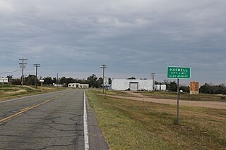
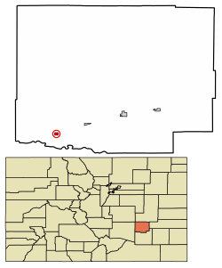
Haswell is a Statutory Town located in Kiowa County, Colorado, United States. The town population was 71 at the 2020 United States Census.

<span class="mw-page-title-main">Kim, Colorado</span> Town in Colorado, United States

Kim is a Statutory Town in Las Animas County, Colorado, United States. The population was 63 at the time of the 2020 United States Census.

<span class="mw-page-title-main">Iliff, Colorado</span> Town in Colorado, United States

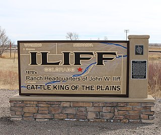
The Town of Iliff is a Statutory Town located in Logan County, Colorado, United States. The population was 246 at the 2020 United States Census.

<span class="mw-page-title-main">Merino, Colorado</span> Town in Colorado, United States

The Town of Merino is a Statutory Town in Logan County, Colorado, United States. The town population was 281 at the 2020 United States Census.

<span class="mw-page-title-main">Wiggins, Colorado</span> Town in Colorado, United States

Wiggins is a statutory town in Morgan County, Colorado, United States. The population was 1,401 as of the 2020 census, up from 893 at the 2010 census.

<span class="mw-page-title-main">Manzanola, Colorado</span> Town in Otero County, Colorado, United States

Manzanola is a Statutory Town in Otero County, Colorado, United States. The town population was 341 at the 2020 United States Census.

<span class="mw-page-title-main">Akron, Colorado</span> Town in Colorado, United States

Akron is the Statutory Town that is the county seat and the most populous municipality of Washington County, Colorado, United States. The town population was 1,757 at the 2020 United States Census.

<span class="mw-page-title-main">Otis, Colorado</span> Town in Colorado, United States

Otis is a Statutory Town in Washington County, Colorado, United States. The population was 511 at the 2020 census.

<span class="mw-page-title-main">Hudson, Colorado</span> Town in Colorado, United States

The Town of Hudson is a home rule municipality in Weld County, Colorado, United States. The population was 1,651 at the 2020 census.

<span class="mw-page-title-main">Nunn, Colorado</span> Town in Colorado, United States

Nunn is a Statutory Town in Weld County, Colorado, United States. The population was 504 at the 2020 census.

<span class="mw-page-title-main">Pierce, Colorado</span> Town in Colorado, United States

Pierce is a Statutory Town in Weld County, Colorado, United States. The population was 1,097 at the 2020 census. The town is a rural agricultural community located on the Colorado Eastern Plains along U.S. Highway 85 north of Greeley.

<span class="mw-page-title-main">Yuma, Colorado</span> City in Colorado, United States

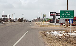
Yuma is a home rule municipality that is the most populous municipality in Yuma County, Colorado, United States. The population was 3,456 at the 2020 census.

<span class="mw-page-title-main">Coal Creek, Colorado</span> Town in Colorado, United States

The Town of Coal Creek is a Statutory Town located in Fremont County, Colorado, United States. The town population was 364 at the 2020 United States Census. Coal Creek is a part of the Cañon City, CO Micropolitan Statistical Area and the Front Range Urban Corridor.

References

  1. 1 2 "Active Colorado Municipalities". State of Colorado, Department of Local Affairs. Archived from the original on December 12, 2009. Retrieved September 1, 2007.
  2. "Colorado Municipal Incorporations". State of Colorado, Department of Personnel & Administration, Colorado State Archives. December 1, 2004. Retrieved September 2, 2007.
  3. "2019 U.S. Gazetteer Files". United States Census Bureau. Retrieved July 1, 2020.
  4. "US Board on Geographic Names". United States Geological Survey. October 25, 2007. Retrieved January 31, 2008.
  5. 1 2 United States Census Bureau. "Olney Springs town; Colorado" . Retrieved April 25, 2023.
  6. "ZIP Code Lookup". United States Postal Service. Archived from the original (JavaScript/HTML) on January 1, 2008. Retrieved November 27, 2007.
  7. "Post offices". Jim Forte Postal History. Retrieved July 6, 2016.
  8. Dawson, John Frank (1954). Place names in Colorado: why 700 communities were so named, 150 of Spanish or Indian origin. Denver, CO: The J. Frank Dawson Publishing Co. p. 38.
  9. "US Gazetteer files: 2010, 2000, and 1990". United States Census Bureau. February 12, 2011. Retrieved April 23, 2011.
  10. http://www.privateci.org/private_pics/col1004.pdf [ bare URL PDF ]