
Malabar District, also known as Malayalam District, was an administrative district on the southwestern Malabar Coast of Bombay Presidency (1792–1800), Madras Presidency (1800–1937), Madras Province (1937–1950) and finally, Madras State (1950–1956) in India. It was the most populous and the third-largest district in the erstwhile Madras State. The historic town of Calicut was the admisnitrative headquarters of this district.
The term Kerala was first epigraphically recorded as Cheras (Keralaputra) in a 3rd-century BCE rock inscription by the Mauryan emperor Ashoka of Magadha. It was mentioned as one of four independent kingdoms in southern India during Ashoka's time, the others being the Cholas, Pandyas and Satyaputras. The Cheras transformed Kerala into an international trade centre by establishing trade relations across the Arabian Sea with all major Mediterranean and Red Sea ports as well those of Eastern Africa and the Far East. The dominion of Cheras was located in one of the key routes of the ancient Indian Ocean trade. The early Cheras collapsed after repeated attacks from the neighboring Cholas and Rashtrakutas.
Deshabhimani is a Malayalam newspaper and the organ of the Kerala State Committee of the CPI(M). It started as a weekly in Kozhikode on 6 September 1942 and converted to a daily in 1946. The paper now has ten different printing centres: Kozhikode, Kochi, Thiruvananthapuram, Kannur, Kottayam, Thrissur, Palakkad, Alappuzha, Kollam and Malappuram. At present, Puthalath Dinesan State Secretariat Member of the CPI(M) is the Chief Editor of the paper, K.J. Thomas, CPI(M), secretariat member of the CPI(M), the General Manager and V. B Parameshwaran, the Resident Editor.

Kerala Agricultural University (KAU) is a state university for agricultural education, recognised as a State Agricultural University by the Indian Council of Agricultural Research (ICAR). It is situated in Vellanikkara, Kerala, India.

Kerala, a state in Southern India, has a network of 11 National Highways, 72 State Highways and many district roads.
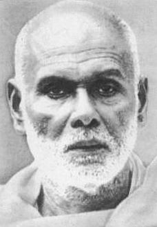
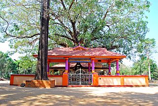
Narayana Guru built temples at various locations in India: Kollam, Thiruvananthapuram, Thrissur, Kannur, Anchuthengu, Thalassery, Kozhikode, Mangalore. Some of the temples built by the guru are:
Desamangalam is a village in Thrissur district which located in the state of Kerala, India.

North Malabar refers to the geographic area of southwest India covering the state of Kerala's present day Kasaragod, Kannur, and Wayanad districts, and the taluks of Vatakara and Koyilandy in the Kozhikode District of Kerala and the entire Mahé Sub-Division of the Union Territory of Puducherry. Traditionally North Malabar has been defined as the northern portion of the erstwhile Malabar District which lies between Chandragiri River and Korapuzha River. The region between Netravathi River and Chandragiri River, which included the portions between Mangalore and Kasaragod, are also often included in the term North Malabar, as the Kumbla dynasty in the southernmost region of Tulu Nadu, had a mixed lineage of Malayali Nairs and Tuluva Brahmins.
The Indian state of Kerala borders with the states of Tamil Nadu on the south and east, Karnataka on the north and the Arabian Sea coastline on the west. The Western Ghats, bordering the eastern boundary of the State, form an almost continuous mountain wall, except near Palakkad where there is a natural mountain pass known as the Palakkad Gap.[1] When the independent India amalgamated small states together, Travancore and Cochin states were integrated to form Travancore-Cochin state on 1 July 1949. However, Malabar remained under the Madras province. The States Reorganisation Act of 1 November 1956 elevated Kerala to statehood.

Eranad also known as Ernad refers to the erstwhile province in the midland area of Malabar, consisting of Malappuram and nearby regions such as Anakkayam, Manjeri, Kondotty, Nilambur, etc. Currently Eranad Taluk is a Taluk in Malappuram district. Eranad was ruled by a Samanthan Nair clan known as Eradis, similar to the Vellodis of neighbouring Valluvanad and Nedungadis of Nedunganad. The rulers of Eranad were known by the title Eralppad/Eradi. They also used the title Thirumulpad.
The Kerala Urban Road Transport Corporation (KURTC) was a state-run bus company which started with more than 500 low-floor buses in Kerala. KURTC used to run complete and individual services in Thiruvananthapuram & Ernakulam districts. The remaining 12 districts were divided into 5 clusters ; Cluster I comprises Kozhikode, Wayanad and Malappuram; Cluster II Kottayam, Thodupuzha, and Pathanamthitta; Cluster III Kannur and Kasaragod; Cluster IV Thrissur and Palakkad; and Cluster V Kollam and Alappuzha. COVID gravely affected the profitability and sustenance of this service, and the buses got rusted due to non usage and only 97 were functional out of which 70 were then given to City Circular Bus service. KURTC shut down all operations in 2022. Even their official website www.kurtc.in was closed down, thus signaling the end of a golden era of cheap and convenient transport service for customers.

Quilon or Coulão, officially Kollam, is one of the ancient civilizations in India. It is one of the oldest port cities in the Malabar Coast and was the capital city of historic Venad Kingdom and Travancore Kingdom. Quilon was once an important trading port in India. It was also known as Desinganadu. It is now known as the "Cashew Capital of the World".
Malappuram is one of the 14 districts in the South Indian state of Kerala. The district has a unique and eventful history starting from pre-historic times. During the early medieval period, the district was the home to two of the four major kingdoms that ruled Kerala. Perumpadappu was the original hometown of the Kingdom of Cochin, which is also known as Perumbadappu Swaroopam, and Nediyiruppu was the original hometown of the Zamorin of Calicut, which is also known as Nediyiruppu Swaroopam. Besides, the original headquarters of the Palakkad Rajas were also at Athavanad in the district.
Waterways have always been an important mode of transport in Kerala. The total length of navigable route in Kerala was 1,900 kilometres and the navigable rivers constitute about 54 per cent of the waterways. The 41 West-flowing rivers together with the backwaters are an integrated part of the inland navigation system in Kerala. In Kerala water transportation through these channels are mainly small distant passenger services, informal country boats, freight transportation to PSU's such as Fertilisers and Chemicals Travancore, Kochi etc.


