Outwell

Last updated

Outwell
Saint Clements, Outwell South West Norfolk.jpg
Saint Clement's, Outwell
Norfolk UK location map.svg
Red pog.svg
Outwell
Location within Norfolk
Area12.21 km2 (4.71 sq mi)
Population2,083 (2011)
  Density 171/km2 (440/sq mi)
OS grid reference TF5103
  London 97 miles (156 km) SSW
Civil parish
  • Outwell
District
Shire county
Region
Country England
Sovereign state United Kingdom
Post town WISBECH
Postcode district PE14
Dialling code 01945
Police Norfolk
Fire Norfolk
Ambulance East of England
UK Parliament
List of places
UK
England
Norfolk
52°37′04″N0°13′54″E / 52.61785°N 0.23157°E / 52.61785; 0.23157

Outwell is a village and civil parish in the borough of King's Lynn and West Norfolk, in the English county of Norfolk. [1]

Contents

At the 2011 Census, the parish had a population of 2,083, [2] an increase from 1,880 at the 2001 Census. [3]

History

According to A Dictionary of British Place Names, derives from the Old English 'wella', meaning "a place at the spring or stream", combined with 'ūte', meaning "outer [or] lower downstream", distinguishing the place from Upwell, which is 1 mile (1.6 km) to the south. In 963 the settlement was referred to as 'Wellan', and in the 1086 Domesday Book , 'Utuuella'. [4] Molycourt Priory in the parish dated from before the Norman Conquest, becoming a cell of Ely Cathedral and surviving until the Dissolution of the Monasteries.

Outwell has an entry in the Domesday Book of 1086. [5] The parish was in the custody William de Warenne. The survey also records 16 bordars with lands worth 5s. as belonging to Saint Benedict's Abbey in Ramsey.[ citation needed ]

There was a Village lock-up until c1871 when it was sold to Mr Elworthy for £19. [6]

Drainage and flooding

In the Middle Ages the River Nene determined the layout of Outwell. Since that time, the landscape of the whole district has consequently been much altered by the construction of several large drains which run through the parish. In the 17th century Popham's Eau was cut to provide a conduit for the waters of the old River Nene into the River Great Ouse at Salter's Lode. This was followed by many alterations and new drains being dug. In May 1862 one sixth of the Parish of Outwell was inundated with water when the Middle Level Drain burst through its banks. It took three years before the area had fully recovered from the flood. Also constructed across the parish was the Wisbech Canal, now disused, which followed the course of the Well Stream as far as Outwell church and then struck across in a southeasterly direction to join Popham's Eau at Nordelph.

One benefit of the drains, washes and other watercourse around the Fens is the sport of Fen skating. During the cold winters of the 1820s and 1830s there were a number of fenmen who made a name for themselves as skaters, such as James May of Upwell. [7]

Beaupré Hall

Beaupré Hall was a large 16th-century manor house on the outskirts of Outwell, built by the Beaupre family, who also financed catholic chapels attached to the church at Outwell. It was later lived in by Robert Bell during the reign of Elizabeth I. In decline since the Victorian era, during the First World War, the hall was commandeered by the RAF and later used for holiday housing. Following this the Hall fell into a state of further disrepair until its demolition in 1966. [8] [9]

Geography

The village is 45 miles (70 km) west of Norwich, 12 miles (20 km) south-west of King's Lynn and 80 miles (100 km) north of London; the nearest town is Wisbech, which is 5 miles (8 km) north-west of the village.

Outwell is on the route of the A1101 road, close to the A47. [10] The nearest railway station is Downham Market on the Fen Line between King's Lynn and Cambridge, and the nearest airport is Norwich Airport.

The village and parish of Outwell is on the western edge of the county of Norfolk which borders Cambridgeshire. Until 1990 Outwell parish was split with half in Norfolk and half in Cambridgeshire with the boundary falling along the old course of the River Nene. The boundary also cut straight through the middle of the village. In 1935 the part of Outwell which was in Cambridgeshire was reduced in size to enlarge the nearby village of Emneth. Outwell parish today is part of the King's Lynn and West Norfolk local government district.

The village and parish is traversed by drainage channels which characterize this part of Fenland Norfolk. The eastern corner of the parish is cut north to south by the Middle Level main Drain. Crossing the parish from east to west is the Well Creek drain. The north and eastern parts of the parish consist of arable and pasture fields, the eastern area referred to as Walsingham Fens and the north area as Well Moors. On the edges of the village there is a small amount of woodland near Birdbeck Field and to the south and at Church Field to the east.

Notable people


Further reading

Related Research Articles

<span class="mw-page-title-main">Cambridgeshire</span> County of England

Cambridgeshire is a ceremonial county in the East of England and East Anglia. It is bordered by Lincolnshire to the north, Norfolk to the north-east, Suffolk to the east, Essex and Hertfordshire to the south, and Bedfordshire and Northamptonshire to the west.

<span class="mw-page-title-main">The Fens</span> Natural region on the east coast of England

The Fens, also known as the Fenlands, in eastern England are a naturally marshy region supporting a rich ecology and numerous species. Most of the fens were drained centuries ago, resulting in a flat, dry, low-lying agricultural region supported by a system of drainage channels and man-made rivers and automated pumping stations. There have been unintended consequences to this reclamation, as the land level has continued to sink and the dykes have been built higher to protect it from flooding.

<span class="mw-page-title-main">Welney</span> Human settlement in England

Welney is a village and civil parish in the Fens of England, and the county of Norfolk. The village is about 10 miles (16 km) south-west of the town of Downham Market, 20 miles (30 km) south of the town of King's Lynn and 45 miles (70 km) west of the city of Norwich. The county boundary with Cambridgeshire is adjacent, with the city of Cambridge 25 miles (40 km) to the south.

<span class="mw-page-title-main">Wisbech</span> Town and civil parish in Cambridgeshire, England

Wisbech is a market town, inland port and civil parish in the Fenland district in Cambridgeshire, England. In 2011 it had a population of 31,573. The town lies in the far north-east of Cambridgeshire, bordering Norfolk and only 5 miles (8 km) south of Lincolnshire. The tidal River Nene running through the town is spanned by two road bridges. Wisbech is in the Isle of Ely and has been described as 'the Capital of The Fens".

Benwick is a village and civil parish in the Fenland district of Cambridgeshire, England. It is approximately 15 miles (24 km) from Peterborough and 30 miles (48 km) from Cambridge. The population of Benwick was recorded as 1137 in the United Kingdom Census 2011 with 452 households. The River Nene passes through the village, which is thus accessible by boat from the inland waterways network in England.

Tydd St Giles is a village in Fenland, Cambridgeshire, England. It is the northernmost village in the Isle of Ely, Cambridgeshire, on the same latitude as Midlands towns such as Loughborough, Leicestershire and Shrewsbury, Shropshire. The village is in the distribution area of one local free newspaper, The Fenland Citizen.

<span class="mw-page-title-main">Wisbech and Upwell Tramway</span>

The Wisbech and Upwell Tramway was a rural standard gauge tramway in East Anglia. It was built by the Great Eastern Railway between Wisbech, Isle of Ely, Cambridgeshire and Upwell, now in Norfolk to carry agricultural produce. Although called a tramway, in many ways it more closely resembled a conventional railway line, and paved the way for the passing of the Light Railways Act 1896.

<span class="mw-page-title-main">Middle Level Navigations</span> Waterway network in eastern England

<span class="mw-page-title-main">Guyhirn</span> Human settlement in England

Guyhirn is a village near the town of Wisbech in Cambridgeshire, England. It is on the northern bank of the River Nene, at the junction of the A141 with the A47. The population is included in the civil parish of Wisbech St Mary. It is notable chiefly for the Chapel of Ease, a rare example of church architecture of the Interregnum (1649–1660), and as a key crossing point of the River Nene.

<span class="mw-page-title-main">Upwell</span> Village in Norfolk, England

Upwell is a village and civil parish in the English county of Norfolk. Upwell village is on the A1101 road, as is Outwell, its conjoined village at the north. The nearest towns are Wisbech to the north-west and Downham Market to the east.

<span class="mw-page-title-main">Wisbech Canal</span> Broad beam canal near Wisbech Cambridgeshire

The Wisbech Canal was a broad canal from Wisbech, Isle of Ely in the Fenland area of Cambridgeshire, England. It ran from the River Nene at Wisbech to the Well Creek at Outwell now in Norfolk, which gave access to the River Great Ouse. It was abandoned in 1926 and filled in during the 1970s.

<span class="mw-page-title-main">Elm, Cambridgeshire</span> Human settlement in England

Elm is a village and civil parish in the Fenland District of Cambridgeshire, England. In Domesday, it is called Helle.

<span class="mw-page-title-main">Emneth</span> Human settlement in England

Emneth is a village and civil parish in the English county of Norfolk. The village is located 2.9 miles (4.7 km) south-east of Wisbech, 12 miles (19 km) south-west of King's Lynn and 46 miles (74 km) west of Norwich, close to the course of the River Nene.

<span class="mw-page-title-main">Tilney St Lawrence</span> Human settlement in England

Tilney St Lawrence is a village and a civil parish in the English county of Norfolk The village is 52.3 miles (84.2 km) west of Norwich, 9.7 miles (15.6 km) south-south-west of King's Lynn and 104 miles (167 km) north of London. The nearest town is Wisbech which is 8.3 miles (13.4 km) west-south-west of the village. The village lies to the south of the route of the A47 between Peterborough and Kings Lynn. The parish of Tilney St Lawrence in the 2001 census had a population of 1,465, increasing to 1,576 at the 2011 Census. For the purposes of local government, the parish falls within the district of King's Lynn and West Norfolk.

<span class="mw-page-title-main">Walsoken</span> Human settlement in England

Walsoken is a settlement and civil parish in Norfolk, England, which is conjoined as a suburb at the northeast of the town of Wisbech, Isle of Ely, Cambridgeshire.

<span class="mw-page-title-main">West Walton</span> Human settlement in England

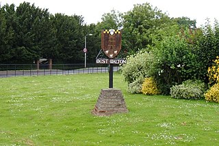
West Walton is a village and civil parish in the King's Lynn and West Norfolk District of Norfolk, England.

<span class="mw-page-title-main">Downham West</span> Human settlement in England

Downham West is a civil parish in the English county of Norfolk The parish is 47.6 miles (76.6 km) west of Norwich, 16.3 miles (26.2 km) south-south-west of King's Lynn and 96.2 miles (154.8 km) north of London. The nearest town is Downham Market which is 2.5 miles (4.0 km) north east of the parish. The nearest railway station is at Downham Market for the Fen Line which runs between King's Lynn and Cambridge. The nearest airport is Norwich International Airport. The parish of Downham West, in the 2001 census, has a population of 285, rising marginally to 286 at the Census 2011. For the purposes of local government, the parish falls within the district of King's Lynn and West Norfolk.

<span class="mw-page-title-main">Stradsett</span> Human settlement in England

Stradsett is a village and civil parish in the English county of Norfolk The village is 40.8 miles (65.7 km) west of Norwich, 11.3 miles (18.2 km) south of King's Lynn and 96.4 miles (155.1 km) north of London. The nearest town is Downham Market which is 3.5 miles (5.6 km) west of the parish. The village is located on the A1122 which runs between Outwell and Swaffham. The A134 between King's Lynn and Colchester also passes through the parish. The nearest railway station is at Downham Market for the Fen Line which runs between King's Lynn and Cambridge. The nearest airport is Norwich International Airport. The parish of Stradsett, in the 2001 census, has a population of 60. For the purposes of local government, the parish falls within the district of King's Lynn and West Norfolk. At the 2011 Census the population remained less than 100 and was included in the civil parish of Crimplesham.

<span class="mw-page-title-main">Nordelph</span> Human settlement in England

Nordelph is a civil parish near Downham Market in the English county of Norfolk.

<span class="mw-page-title-main">Christchurch, Cambridgeshire</span> Human settlement in England

Christchurch is a village in the Fenland district of Cambridgeshire, England. The population of the civil parish at the 2011 Census was 833. The village is sited close to the Cambridgeshire/Norfolk border.

References

  1. Ordnance Survey (2006). OS Explorer Map 228 – March & Ely. ISBN   0-319-23802-4
  2. "Outwell (Parish): Key Figures for 2011 Census". Neighbourhood Statistics. Office for National Statistics. Retrieved 29 August 2015.
  3. "Outwell (Parish): Key Figures for 2001 Census". Neighbourhood Statistics. Office for National Statistics. Retrieved 6 May 2017.
  4. Mills, Anthony David (2003); A Dictionary of British Place Names, Oxford University Press, revised edition (2011), p.357. ISBN   019960908X
  5. The Domesday Book, England's Heritage, Then and Now, (Editor: Thomas Hinde), Norfolk, page 192, Outwell, ISBN   1-85833-440-3
  6. "Outwell Lock-up". Cambridge Independent Press. 18 November 1871. p. 6.
  7. N & A Goodman 1882 Handbook of fen skating. London.
  8. 1 2 "Wisbech Hundred: Outwell and Upwell", British History Online, quoting A History of the County of Cambridge and the Isle of Ely: Volume IV
  9. Worsley, G., England's Lost Houses, Aurum Press Limited, 2002
  10. County A to Z Atlas, Street & Road maps Norfolk, page 230 ISBN   978-1-84348-614-5

Further reading

Smith, William P (2017). OUTWELL IN A NUTSHELL. Carillson Publications. ISBN   978-0-9543997-4-0.

Commons-logo.svg Media related to Outwell at Wikimedia Commons