Ouvrage Hochwald

Last updated

Ouvrage Hochwald
Part of Maginot Line
Northeast France
Ouvrage du Hochwald (ligne Maginot).jpg
Block 6
France location map-Regions and departements-2016.svg
Red pog.svg
Ouvrage Hochwald
Coordinates 48°59′04″N7°50′01″E / 48.9845°N 7.8337°E / 48.9845; 7.8337
TypeGros Ouvrage
Site information
Controlled byFrance
Open to
the public
No
ConditionIn use by French Air Force
Site history
Built1929-1933
Built byCORF
MaterialsConcrete, steel, deep excavation
Battles/wars Battle of France, Lorraine Campaign
Garrison information
Garrison1070
Ouvrage Hochwald
Type of work:Large artillery work (Gros ouvrage)
sector
└─sub-sector
Fortified Sector of Haguenau
└─Péchelbronn
Work number:E 700, Ouvrage F
Regiment:22nd Fortress Infantry Regiment (RIF) + 156thPosition Artillery Regiment (RAP)
Number of blocks:14

Ouvrage Hochwald is a gros ouvrage of the Maginot Line, one of the largest fortifications in the Line. Located on the Hochwald ridge in the Fortified Sector of Haguenau in the community of Drachenbronn-Birlenbach in the Bas-Rhin department of northeastern France, it was designed to protect the northern Vosges region of France. Ouvrage Hochwald is sometimes considered as two ouvrages because of its separation of the western and the eastern portions of the ouvrage. Uniquely, the original plans for the position included an elevated battery to the rear with long-range 145 mm or 155 mm gun turrets of a new kind. Hochwald is used by the French Air Force as an armoured air defense coordination center.

Contents

Design and construction

The Hochwald site was surveyed by CORF (Commission d'Organisation des Régions Fortifiées), the Maginot Line's design and construction agency, in 1928. Work began the next year, and the position became operational in 1933. [1] [2] The gros ouvrage is unique in size and extent. The reduit at the peak of the Hochwald would have provided heavy, long-range artillery cover for the entire sector. [1] [nb 1]

Description

Hochwald is flanked on the west by Ouvrage Four-à-Chaux and on the east by Ouvrage Schoenenbourg, comprising one of the strongest points on the Line. The height of the Hochwald ridge overlooks the area of Wissembourg to the east, which forms a gap between the hills of the northern Vosges and the Palatinate forest on the west and the Bienwald on the east. The landscape on the French side of the border is an open farmed plain for 24 kilometres (15 mi) eastwards to the Rhine. The ouvrage formed part of the "principal line of resistance", an element of defense in depth that was preceded by a line of advance posts close to the border and backed by a line of shelters for infantry. Hochwald's fighting elements were placed in the line of resistance, with the entrances and their associated supply lines protected by infantry in the third line, 1-kilometre (0.62 mi) or more to the rear. The entrances were served by narrow-gauge 60-centimetre (24 in) railways, that branched from a line paralleling the front and connecting to supply depots. The rail lines ran directly into the munitions entry of the ouvrage and all the way out to the combat blocks, a distance of nearly 2,000 metres (6,600 ft). [5]

Ouvrage Hochwald includes ten combat blocks and three entrance blocks: five combat blocks located on each side of the Hochwald massif, an ammunition entrance, a personnel entrance located on the back (south) side and an intermediate personnel entrance located in the middle of the principal gallery. [1] Hochwald was equipped in 1940 with the following armament:

Eastern wing (O 720)

Western wing (O 703)

Anti-tank ditch and casemates

American soldiers at Hochwald West, Block 13 in 1944 Maginot Line 1944.jpg
American soldiers at Hochwald West, Block 13 in 1944

A chevroned ditch runs over the ridge between the east and west wings with a series of casemates located to sweep the ditch with fire. The casemates are not connected to each other or to the ouvrage.

Entries, observation post and réduit

The planned réduit for long-range 145mm or 155mm guns was never built. Its entry was partially completed and never armed. Partially completed galleries run some hundreds of meters into the hill from the rear to the location of the planned combat blocks at the crest of the ridge. [1] [20] [21]

Entry blocks 8 and 9 serve the main ammunition magazine, utility area (usine) and underground barracks. They are more than a kilometer from the west wing combat blocks and close to two kilometers from the east wing blocks, [22] at a depth underground of approximately 30 metres (98 ft). The western underground barracks and the large "M1"-type magazine are just inside the entries. These areas were converted and expanded to form the basis of Base Aérienne 901 Drachenbronn [23] in a manner similar to the adaptation of Ouvrage Rochonvillers for the NATO CENTAG headquarters of the 1960s.

Block 20 is an isolated and unconnected observation block on the summit of the Hochwald with a VP cloche and a GFM cloche. [1] [22]

The generating plant was split into two units: the west generating plant comprised four Sulzer engines of 240 hp each, and the east four Sulzer engines of 165 hp each. [1]

Casemates and shelters

A series of detached casemates and infantry shelters are in the vicinity of Hochwald, including

Ouvrage Bremmelbach

Two casemates to the east of Hochwald comprise the remainder of the planned petit ouvrage Bremmelbach, canceled in 1929.

The two casemates are linked by an underground gallery. [1]

Manning

The 1940 manning of the ouvrage under the command of Lieutenant Colonel Miconnet comprised 1022 men and 41 officers of the 22nd Fortress Infantry Regiment and the 156th Position Artillery Regiment. The units were under the umbrella of the 5th Army, Army Group 2. Interval troops covering the areas between and outside the fortifications were assigned to the 16th and 70th Infantry Divisions, 12th Corps. [25] [26] The nearby Casernement de Drachenbronn provided peacetime above-ground barracks and support services to Hochwald and other positions in the area. [27] [28]

History

See Fortified Sector of Haguenau for a broader discussion of the Haguenau sector of the Maginot Line.
Hochwald Block 9 Hochwald B7 1.jpg
Hochwald Block 9

Hochwald was one of the most active ouvrages during the Phoney War of 1939–1940. On 8–9 October 1939, Hochwald fired in support of French patrols, revealing deficiencies in gun mounts and ammunition. [29] In November the ouvrage fired on German minelayers. During the Battle of France in June 1940, Hochwald remained unmolested until 16 June, when it fired on Germans moving toward Lembach and received artillery fire and Stuka attacks in return. Attacks came again on the 20th, and Hochwald fired in support of Lembach. More aerial attacks followed on the 22nd.

In 1944, the retreating Germans blew up blocks 1, 3 6 and 16, and all three entrance blocks, as well as all turrets. [30] In 1944 Hochwald (renamed Werk Hochwald) was used as an underground factory. [31]

With the formation of NATO, French interest in a renewed fortification system against a Warsaw Pact invasion caused the renovation of most of the larger Maginot fortifications by the 1950s. Hochwald joined Schoenenbourg, Four-à-Chaux and Lembach in a system called the Môle de Haguenau, with work at Hochwald proceeding in 1952 to repair the war damage. However, in 1956, Hochwald was transferred to the French Air Force for use as an air defense command center. New underground galleries were built in the rear (i.e., near the entrance blocks), and were even provided with an internal machine gun port. [32] The facility was briefly known as Ouvrage H before its designation as Base Aérienne 901 Drachenbronn. [33]

Current condition

Hochwald is part of the French Air Force's Drachenbronn Air Base, and is used as a hardened command center. It is closed to the public except for the Pierre Jost Museum, which is open on days of national remembrance. [23] In 2015 the military base was closed, only the radar antennas are still in use and are remotely controlled. [34] Another Maginot ouvrage, Mont Agel of the Alpine Line, performs a similar function in southeastern France. [35]

See also

Notes

  1. English-language sources use the French term ouvrage as the preferred term for the Maginot positions, in preference to "fort", a term usually reserved for older fortifications with passive defences in the form of walls and ditches. [3] The literal translation of ouvrage in the sense of a fortification in English is "work." A gros ouvrage is a large fortification with a significant artillery component, while a petit ouvrage is smaller, with lighter arms. [4]
  2. An abri is an infantry shelter, sometimes underground or under earth cover. An abri in the main Maginot Line often closely resembles a casemate, but is more lightly armed and can hold more occupants. [24]

Related Research Articles

Ouvrage Schoenenbourg

Ouvrage Schoenenbourg is a Maginot Line fortification. It is located on the territory of the communes of Hunspach, Schœnenbourg and Ingolsheim, in the French département of Bas-Rhin, forming part of the Fortified Sector of Haguenau, facing Germany. At the east end of the Alsace portion of the Maginot Line, its neighbour is the gros ouvrage Hochwald. It is the largest such fortification open to the public in Alsace. Officially recorded as an historical monument, it retains all its original structural elements. Schoenenbourg was heavily bombarded during the Battle of France in 1940, receiving more enemy ordnance than any other position in France, with no significant damage. In 1945, retreating German troops used explosives to destroy much of the ouvrage. After the war it was fully repaired and placed back into service as part of a programme to use Maginot fortifications to resist a potential Warsaw Pact advance through Europe. By the 1970s the plan had lost favour and funding, and Schoenenboug was abandoned. In 1987 a local organisation undertook Schoenenbourg's preservation, and today it is open to public visitation.

Ouvrage Latiremont

Ouvrage Latiremont is a gros ouvrage of the Maginot Line, located in the Fortified Sector of the Crusnes, sub-sector of Arrancy. It lies between the gros ouvrage Fermont and the petit ouvrage Mauvais Bois, facing Belgium. The village of Doncourt-Cités is nearby. Latiremont was active in 1939-1940, coming under direct attack in late June 1940. It surrendered to German forces on 27 June. After renovations during the Cold War, it was abandoned.

Ouvrage Kobenbusch

Ouvrage du Kobenbusch is a gros ouvrage of the Maginot Line, located in the Fortified Sector of Thionville in the Cattenom Forest. It possesses seven combat blocks and two entrance blocks, one for ammunition and the other for men. It is located between petit ouvrage Bois-Karre and petit ouvrage Oberheid, and was named for the surrounding Kobenbusch Forest.

Ouvrage Hackenberg

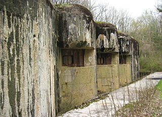
Ouvrage Hackenberg, one of the largest of the Maginot Line fortifications, is part of the Fortified Sector of Boulay. It is situated twenty kilometres east of Thionville, in the Moselle département, near the village of Veckring, on the Hackenberg. It is located between gros ouvrage Billig and petit ouvrage Coucou, facing Germany. The fort occupies the wooded Hackenberg ridge. Before World War II it was considered a showpiece of French fortification technology, and was visited by British King George VI.

Ouvrage Bovenberg is a lesser work of the Maginot Line. Located in the Fortified Sector of Boulay, the ouvrage is located between petits ouvrages Berenbach and Denting, facing Germany. It consists of two infantry blocks and two artillery blocks.

Ouvrage Coume Annexe Sud

Ouvrage Coume Annexe Sud is a lesser work of the Maginot Line. Located in the Fortified Sector of Boulay, the ouvrage consists of two infantry blocks, one artillery block and one observation block, and is located between petits ouvrages Coume and Mottemberg, facing Germany.

Ouvrage Métrich Ouvrage of the Maginot Line

Ouvrage Métrich located in the village of Kœnigsmacker in Moselle, comprises part of the Elzange portion of the Fortified Sector of Thionville of the Maginot Line. A gros ouvrage, it is the third largest of the Line, after Hackenberg and Hochwald. It lies between petit ouvrage Sentzich and gros ouvrage Billig, facing Germany. Located to the east of the Moselle, it cooperated with Ouvrage Galgenberg to control the river valley.

Ouvrage Mauvais-Bois is a petit ouvrage of the Fortified Sector of the Crusnes on the Maginot Line. It is located between the gros ouvrage Latiremont and the petit ouvrage Bois-du-Four, facing the Belgium/Luxembourg border. The original plan for the position was for two phases of construction, resulting in a gros ouvrage provided with heavy artillery. The increase in tension between France and Germany in the late 1930s caused resources to be diverted elsewhere, and only the first three combat blocks were built. In 1940 the ouvrage was regularly bombarded, but not directly attacked by German infantry. When the French military divested itself of the majority of the Maginot fortifications, Mauvais-Bois was the second to be sold.

Ouvrage Bois-du-Four

Ouvrage Bois-du-Four is a lesser work in the Fortified Sector of the Crusnes of the Maginot Line. The ouvrage consists of a single large combat block without an underground gallery system, and is located between petit ouvrage Mauvais-Bois and gros ouvrage Bréhain, facing Luxembourg. A planned expansion, never carried out, was intended to enlarge Bois-du-Four into a fully equipped gros ouvrage. Bois-du-Four saw little action in either the Battle of France in 1940 or the Lorraine Campaign of 1944. It is preserved by the community of Villers-la-Montagne and may be visited.

Ouvrage Bréhain is part of the Fortified Sector of the Crusnes of the Maginot Line, located near the community of Bréhain-la-Ville in the Meurthe-et-Moselle department of France. Bréhain is flanked by petits ouvrages Mauvais Bois and Aumetz. The gros ouvrage was equipped with long-range artillery, and faced the border with Luxembourg. It saw no major action in either the Battle of France in 1940 or the Lorraine Campaign of 1944. While not open to public visitation, it has been secured and is in relatively good condition when compared to other abandoned Maginot positions. A flanking casemate has been restored and may be visited.

Ouvrage Aumetz is a small work, or petit ouvrage of the Maginot Line. It is part of the Fortified Sector of the Crusnes and is located near the community of Aumetz in the Moselle département of France. The petit ouvrage flanked by the gros ouvrages Bréhain and Rochonvillers, all facing the France-Luxembourg border. Aumetz was initially planned as a gros ouvrage of six combat blocks, but only three infantry blocks were built. Aumetz saw limited action during the Battle of France. In the 1970s it was the first Maginot position to be offered for sale to the public.

Ouvrage Soetrich

Ouvrage Soetrich is a gros ouvrage of the Maginot Line in north-eastern France. Soetrich is located between petits ouvrages Immerhof and Bois Karre, facing the France-Luxembourg border near the town of Hettange-Grande, part of the Fortified Sector of Thionville. Compared with other gros ouvrages, Soetrich is compact in arrangement, with the entries and underground ammunition magazines and barracks in close proximity to the combat blocks, accessed through underground galleries at an average depth of 30 metres (98 ft). Its primary purpose was to cover the main road to Luxembourg, just to the west. Along with its neighbours, Ouvrage Rochonvillers and Ouvrage Molvange, Soetrich was used during the Cold War as a secure command centre for NATO forces.

Ouvrage Haut-Poirier

Ouvrage Haut-Poirier is a lesser work of the Maginot Line. The ouvrage consists of one entry and three infantry blocks, and is located between the Saare valley and petit ouvrage Welschhof, facing Germany. It is the only ouvrage in the Fortified Sector of the Sarre, the remainder of the area being covered by smaller blockhouses and areas of inundation. It was assaulted by German forces during the Battle of France and was captured after a seven-hour bombardment. Haut-Poirier is abandoned, although one of its satellite casemates is maintained as a museum.

Ouvrage Otterbiel

Ouvrage Otterbiel forms part of the Maginot Line in the Fortified Sector of Rohrbach, Sub-sector of Bitche, and is located on the Camp de Bitche of the French Army. It is located between gros ouvrage Schiesseck and petit ouvrage Grand Hohekirkel. Part of the Fortified Sector of Rohrbach, the petit ouvrage comprises four combat blocks and an entry block. Due to budget restrictions, a planned flanking infantry block was never constructed. Otterbiel saw no significant action in the Battle of France, and limited action during the 1944/45 Lorraine Campaign. It was renovated for use during the Cold War. Otterbiel is used for ammunition storage by the French Army.

Ouvrage Simserhof

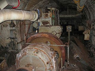
Ouvrage Simserhof is a gros ouvrage of the Maginot Line, located in the French commune of Siersthal in the Moselle department. It faces the German border and is adjoined by the petit ouvrage Rohrbach and the gros ouvrage Schiesseck. Located 4 km west of Bitche, the ouvrage derived its name from a nearby farm. It was part of the Fortified Sector of Rohrbach. During the Battle of France in 1940, the Simserhof supported its neighboring fortifications with partially successful covering artillery fire. After the surrender of France, it was repurposed by the Germans as a torpedo storage depot, and later resisted the American advances of late 1944. The Americans briefly occupied the fort in the first days of 1945 until the German counter-offensive of Operation Nordwind, which allowed them to take back control of the Simserhof. The fort was finally liberated by the 100th Infantry Division on March 15, 1945. Following the war, it was initially repaired for the French Army and later converted into a Maginot Line museum in the early 1960s. Retained by the Ministry of Defense, Simserhof now functions as a museum, and has the most extensive visitor infrastructure of any of the preserved Maginot fortifications.

Ouvrage Schiesseck is a gros ouvrage of the Maginot Line, located near Bitche in the French département of Moselle. Schiesseck is adjoined by gros ouvrage Simserhof and petit ouvrage Otterbiel, all part of the Fortified Sector of Rohrbach, and faces the German frontier. Schiesseck saw comparatively little activity during the Battle of France, surrendering with other positions in its sector on 30 June 1940. During the Lorraine Campaign of 1944 Schiesseck was occupied by German forces and presented a point of resistance to American advances, requiring heavy bombardment and infantry assaults by engineer units to capture. The area was abandoned during the Battle of the Bulge, but was recaptured in March 1945. In the 1950s Schiesseck was repaired as part of a program to re-arm the Maginot Line against a potential advance by Warsaw Pact forces. It was abandoned in the early 1970s. Schiesseck is on military land and is not visitable by the public.

Ouvrage Grand-Hohékirkel is a petit ouvrage of the Maginot Line, located near Bitche in the French département of Moselle. Grand-Hohékirkel is adjoined by gros ouvrage Otterbiel to the west and petit ouvrage Lembach at some distance to the east, and faces the German frontier. It was part of the Fortified Sector of the Vosges.

Ouvrage Lembach

Ouvrage Lembach is a petit ouvrage of the Maginot Line. Lembach is adjoined by petit ouvrage Grand Hohekirkel at some distance to its west and gros ouvrage Four-à-Chaux immediately to its east. It faces the German frontier, and was part of the Fortified Sector of the Vosges. During the Battle of France in 1940, the German 215th Infantry Division broke through the line of smaller fortifications to the west of Lembach, but did not directly attack. After aerial bombardments, Lembach surrendered with the rest of the Maginot fortifications according to the terms of the Second Armistice at Compiègne. After the war Lembach was renovated for further use, but was abandoned by the 1970s.

Ouvrage Four-à-Chaux

Ouvrage Four-à-Chaux is a gros ouvrage of the Maginot Line, located in the community of Lembach, France, in the Bas-Rhin département. Four à Chaux was adjoined by petit ouvrage Lembach and gros ouvrage Hochwald, and faced the German frontier as part of the Fortified Sector of the Vosges. A "four à chaux" is a lime kiln in French, and the ouvrage was located in the area of a limestone quarry and kiln, which operated until 1939. Four-à-Chaux was bombarded by the invading Germans in late June 1940 during the Battle of France with both aerial attacks and artillery bombardments. Four-à-Chaux survived to surrender at the end of the month. Block 1 was destroyed by the Germans before retreating in the face of American advances in 1945. During the 1950s Four-à-Chaux was renovated and reoccupied against a perceived threat from the Soviet Union. It fell out of use in the 1970s, and is now operated as a museum.

Ouvrage Chesnois

Ouvrage Chesnois, also known as Ouvrage Chênois, is a gros ouvrage of the Maginot Line, located in the Fortified Sector of Montmédy, facing Belgium. The ouvrage lies between the towns of Montlibert and Thonne-le-Thil. It possesses six combat blocks. It is located between gros ouvrage Thonnelle and petit ouvrage La Ferté. The position was sabotaged and abandoned by French forces that were ordered to retreat from the exposed position in June 1940 during the Battle of France. The ouvrage is now abandoned and sealed.

References

  1. 1 2 3 4 5 6 7 8 9 10 11 12 Mary, Tome 3, pp. 135–137
  2. Kaufmann 2006, p. 25
  3. Kaufmann 2006, p.13
  4. Kaufmann 2006, p. 20
  5. Mary, Tome 2, p. 53
  6. Puelinckx, Jean; Aublet, Jean-Louis; Mainguin, Sylvie (2010). "Hochwald (go E720 du) Bloc 1". Index de la Ligne Maginot (in French). fortiff.be. Retrieved 17 February 2010.
  7. Puelinckx, Jean; et al. (2010). "Hochwald (go E720 du) Bloc 2". Index de la Ligne Maginot (in French). fortiff.be. Retrieved 17 February 2010.
  8. Puelinckx, Jean; et al. (2010). "Hochwald (go E720 du) Bloc 3". Index de la Ligne Maginot (in French). fortiff.be. Retrieved 17 February 2010.
  9. Puelinckx, Jean; et al. (2010). "Hochwald (go E720 du) Bloc 5". Index de la Ligne Maginot (in French). fortiff.be. Retrieved 17 February 2010.
  10. Puelinckx, Jean; et al. (2010). "Hochwald (go E720 du) Bloc 6". Index de la Ligne Maginot (in French). fortiff.be. Retrieved 17 February 2010.
  11. Puelinckx, Jean; et al. (2010). "Hochwald (go E720 du) Bloc 7 (entrée est)". Index de la Ligne Maginot (in French). fortiff.be. Retrieved 17 February 2010.
  12. Puelinckx, Jean; et al. (2010). "Hochwald (go E720 du) Bloc 7bis". Index de la Ligne Maginot (in French). fortiff.be. Retrieved 17 February 2010.
  13. Puelinckx, Jean; et al. (2010). "Hochwald (go E703 du) Bloc 12". Index de la Ligne Maginot (in French). fortiff.be. Retrieved 17 February 2010.
  14. Puelinckx, Jean; et al. (2010). "Hochwald (go E703 du) Bloc 13". Index de la Ligne Maginot (in French). fortiff.be. Retrieved 17 February 2010.
  15. Puelinckx, Jean; et al. (2010). "Hochwald (go E703 du) Bloc 14". Index de la Ligne Maginot (in French). fortiff.be. Retrieved 17 February 2010.
  16. Puelinckx, Jean; et al. (2010). "Hochwald (go E703 du) Bloc 15". Index de la Ligne Maginot (in French). fortiff.be. Retrieved 17 February 2010.
  17. Puelinckx, Jean; et al. (2010). "Hochwald (go E703 du) Bloc 16". Index de la Ligne Maginot (in French). fortiff.be. Retrieved 17 February 2010.
  18. Puelinckx, Jean; et al. (2010). "Hochwald (go E703 du) Bloc 8 (entrée M ouest)". Index de la Ligne Maginot (in French). fortiff.be. Retrieved 17 February 2010.
  19. Puelinckx, Jean; et al. (2010). "Hochwald (go E703 du) Bloc 9 (entrée H ouest)". Index de la Ligne Maginot (in French). fortiff.be. Retrieved 17 February 2010.
  20. Kaufmann 2006, p. 21
  21. Mary, Tome 1, p. 56
  22. 1 2 Puelinckx, Jean; et al. (2010). "Hochwald (go E700 du)". Index de la Ligne Maginot (in French). fortiff.be. Retrieved 17 February 2010.
  23. 1 2 "Historique de la base". Base Aérienne 901 (in French). French Ministry of Defense. 2 February 2007. Archived from the original on 20 July 2011. Retrieved 22 January 2010.
  24. Kaufmann 2006, p. 14
  25. Mary, Tome 3, pp. 79, 122. 129, 134
  26. Romanych, pp. 22–24
  27. Mary, Tome 3, p. 125
  28. Wahl, J.B. "Festungsabschnitt Haguenau" (in German). darkplaces.org. Retrieved 11 June 2010.
  29. Kaufmann 2006, p. 150
  30. Mary, Tome 5, pp. 142, 155
  31. Mary, Tome 5, p. 137
  32. Mary, Tome 5, p. 172
  33. Brolli, Antoine (1987–1988). "L'ouvrage "G" de la D.A.T.". Bulletin de la société belfortaine d'émulation (in French) (79). ISSN   0242-5106.
  34. Berring, Franck (2015). Drachenbronn - Base secrète du Hochwald (in French). Toulouse: Édition Privat. p. 129. ISBN   978-2-7089-9264-1.
  35. "Le Centre de Detection et de Controle 05.943: Missions" (in French). French Ministry of Defense. 2 April 2008. Archived from the original on 20 July 2011. Retrieved 25 January 2010.

Bibliography