
Mission San Fernando Rey de España is a Spanish mission in the Mission Hills community of Los Angeles, California. The mission was founded on 8 September 1797 at the site of Achooykomenga, and was the seventeenth of the twenty-one Spanish missions established in Alta California. Named for Saint Ferdinand, the mission is the namesake of the nearby city of San Fernando and the San Fernando Valley.

Toronto is a lakeside suburb within the City of Lake Macquarie, Greater Newcastle in New South Wales, Australia, approximately 28 kilometres (17 mi) from Newcastle's central business district and is a commercial hub for the sprawling suburbs on the western shore of the lake. It is one of the major centres in the City of Lake Macquarie.

Alloway is a village in South Ayrshire, Scotland, located on the River Doon. It is best known as the birthplace of Robert Burns and the setting for his poem "Tam o' Shanter". Tobias Bachope, the mason responsible for the construction of Hopetoun House, Craigiehall, and Kinross House, also hailed from Alloway. Some historic parts of the village make up a conservation area.

Potchefstroom, colloquially known as Potch, is an academic city in the North West Province of South Africa. It hosts the Potchefstroom Campus of the North-West University. Potchefstroom is on the Mooirivier, roughly 120 km (75 mi) west-southwest of Johannesburg and 45 km (28 mi) east-northeast of Klerksdorp.

Raj Bhavan is a residential palace and fort situated in Dona Paula, Goa, which serves as the official residence of the governor of Goa. The sprawling 88 acres estate is located on a cape in the Goan capital, Panjim. Known by the name "Palácio do Cabo" until it gained official status as the residence of the governor of Goa, this palace is said to be built between the 16th and 17th centuries in the erstwhile Portuguese India. The fort is strategically positioned facing the Arabian sea opposite the well-preserved 17th century Forte Aguada.
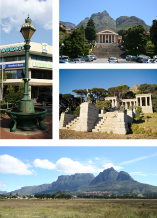
Rondebosch is one of the Southern Suburbs of Cape Town, South Africa. It is primarily a residential suburb, with shopping and business districts as well as the main campus of the University of Cape Town.

Sea Point is an affluent and densely populated suburb of Cape Town, situated between Signal Hill and the Atlantic Ocean, a few kilometres to the west of Cape Town's Central Business District (CBD). Moving from Sea Point to the CBD, one passes first through the small suburb of Three Anchor Bay, then Green Point. Seaward from Green Point is the area known as Mouille Point, where the local lighthouse is situated. It borders to the southwest the suburb of Bantry Bay. It is known for its large Jewish population, synagogues, and kosher food options.

George is the second largest city in the Western Cape province of South Africa. The city is a popular holiday and conference centre, as well as the administrative and commercial hub and the seat of the Garden Route District Municipality. It is named after the British Monarch George III.

The Castle of Good Hope is a bastion fort built in the 17th century in Cape Town, South Africa. Originally located on the coastline of Table Bay, following land reclamation the fort is now located inland. In 1936 the Castle was declared a historical monument and following restorations in the 1980s it is considered the best preserved example of a Dutch East India Company fort.

Hampton Hill is a district in the London Borough of Richmond upon Thames to the south of Twickenham. It is bounded by Fulwell and Twickenham Golf Courses to the northwest; a railway line road bridge at the junction of Wellington Road and Clonmel Road; a line southward just east of Wellington Road; Bushy Park to the southeast; and the artificial Longford River to the south and west. Hampton Hill is served by Fulwell railway station and Hampton railway station on the Shepperton to Waterloo line. It is part of what is collectively known as The Hamptons. Much of Hampton Hill High Street, and some neighbouring residential areas are designated as a conservation area.
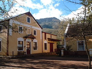
Genadendal is a town in the Western Cape province of South Africa, built on the site of the oldest mission station in the country. It was originally known as Baviaanskloof, but was renamed Genadendal in 1806. Genadendal was the place of the first Teachers' Training College in South Africa, founded in 1838.

Longside is a village located in Aberdeenshire, Scotland, consisting of a single main street. It lies seven miles inland from Peterhead and two miles from Mintlaw on the A950. Its population in 2001 was 721. The River Ugie flows through it.

Williston is a town in Northern Cape, South Africa. Town 103 km north-east of Calvinia and 140 km south-west of Carnarvon.
Alvarado Terrace Historic District is a designated historic district in the Pico-Union district of Los Angeles, California. It is located southwest of Downtown Los Angeles, along Alvarado Terrace between Pico Boulevard and Alvarado Street.

Béthanie is a historic building complex located in Pok Fu Lam, in Southern District, Hong Kong built in 1875 as a sanatorium by the Paris Foreign Missions Society.

George Museum is a cultural history museum located in the town of George, Western Cape, South Africa. It preserves the history of the town of George with a special focus on the timber industry. It also houses an art collection. The museum was started by Charles Sayers, in 1967 in a single room in Courtenay Street. The museum is now housed in the building the first magistrate, Adrian van Kervel built as the Drostdy (residency) from 1812 -1815.

St Brides Major is a community on the western edge of the Vale of Glamorgan, South Wales. Its largest settlement is the village of St Brides Major, and also includes the villages of Ogmore-by-Sea and Southerndown, and the hamlets of Ogmore Village, Castle-upon-Alun, Heol-y-Mynydd, Norton and Pont-yr-Brown It is notable for coastal geology and scenery, limestone downlands and fossilised primitive mammals, sea cliffs and beaches, two Iron Age hillforts, three medieval castle sites,, two stepping stone river crossings and a clapper bridge. Three long distance paths cross the community. It is the western limit of the Vale of Glamorgan Heritage Coast, and has a visitor centre and tourist facilities.

The South African Sendinggestig Museum was established in 1977 and is currently situated in the centre of Cape Town, Western Cape, South Africa. It is a province-aided museum which receives support from the Government of the Western Cape Province.

St John's Anglican Church is a heritage-listed church at 278 Ford Street, Berserker, Rockhampton, Rockhampton Region, Queensland, Australia. It was built in 1912. It was added to the Queensland Heritage Register on 5 August 2003.

All Saints Anglican Church is a heritage-listed church at Darnley Island, Torres Strait Island Region, Queensland, Australia. It was built from 1919 to 1938. It was added to the Queensland Heritage Register on 21 October 1992.


