Vleesbaai

Last updated
Vleesbaai
Vleesbaai1.JPG
Modern day view of the beach from Hoekbaai
South Africa Western Cape location map.svg
Red pog.svg
Vleesbaai
South Africa adm location map.svg
Red pog.svg
Vleesbaai
Africa location map.svg
Red pog.svg
Vleesbaai
Coordinates: 34°17′31″S21°54′50″E / 34.292°S 21.914°E / -34.292; 21.914 Coordinates: 34°17′31″S21°54′50″E / 34.292°S 21.914°E / -34.292; 21.914
Country South Africa
Province Western Cape
District Garden Route
Municipality Mossel Bay
Area
[1]
  Total1.05 km2 (0.41 sq mi)
Population
 (2011) [1]
  Total194
  Density180/km2 (480/sq mi)
Racial makeup (2011)
[1]
   Black African 7.3%
   Coloured 3.6%
   Indian/Asian 0.5%
   White 88.6%
First languages (2011)
[1]
   Afrikaans 94.1%
   English 3.7%
   Tswana 1.1%
  Other1.1%
Time zone UTC+2 (SAST)
Postal code (street)
6504 (Johnson's Post)

Vleesbaai, a seaside vacation town, situated between Mossel Bay and Gouritsmond in Western Cape, South Africa.

Contents

History

Although the native Khoi people inhabited the southern shores of Africa long before it was discovered by Europeans on their seafaring expeditions, Vleesbaai, like many other South African coastal places, is known today by the name it was given by European explorers. The first European to set eyes on the bay now known as Vleesbaai was Portuguese explorer Bartolomeu Dias in 1488. Dias would have come into the bay, as he discovered the southern shores of the African continent en route to the East, in the process of establishing the spice route.

It took more than a century after the Bartolomeu Dias expeditions for Vleesbaai to get this name, and the bay was christened by another explorer, the Dutchman Paulus van Caerden. It was due to bad wind conditions on 14 July 1601 that Van Caerden was forced to seek refuge in the protected bay. He was pleased to discover that many natives ashore were willing to trade their well-fed livestock for scrap metal and other fancy Western articles and goods – he named it Vleys Baeye, the Old Dutch word for Vleesbaai, directly translated into English as “Bay of meat”. Van Caerden was also the man responsible for naming the neighbouring settlements in the vicinity, including Visbaai (Afrikaans, meaning 'Fish Bay') to the west, and Mosselbaai (Afrikaans, meaning 'Mussel Bay'), known as Mossel Bay in South African English, approximately 30 km to the east of Vleesbaai.

For many years there was confusion as to which of the two neighbouring bays – Vleesbaai en Visbaai – were which. This was largely because the names of the bays were swapped around and displayed incorrectly on maps for many years. However, it was officially corrected in 1972 by the Surveyor-General’s Trigonometry Surveys and Mapping Office.

Vleesbaai and its surrounding region proved to be good agricultural land for livestock, and as result it saw an increase of nomadic farmers from the Cape region creating farm settlements in the area during the greater part of the nineteenth century. It was only towards the first part of the twentieth century that the first informal settlements started in the bay as a holiday camping site for the local farmers. [2]

Modern day

Vleesbaai is a seaside vacation town made up of approximately 500 plots of varying sizes and controlled by three companies and three homeowners associations.

The houses in Vleesbaai are largely owned by geographically diverse South Africans, who use these houses as holliday accommodation, although there are a number of permanent residents, mainly retirees who have made their holiday homes their permanent homes. As a result, Vleesbaai’s occupancy fluctuates, with the holiday seasons being particularly busy. The Christmas period, the traditional South African summer holiday, and Easter is in general the time when Vleesbaai enjoys its highest occupancy levels.

Despite larger numbers, Vleesbaai remains relatively uncrowded when compared to other holiday towns in the region – this is largely due to the private nature of home ownership, and therefore limited numbers of visitors and guests even during the busy periods.

The local shop is the only business plot in Vleesbaai, where one can find all the essential groceries and fuel. Due to the small shop size the variety of goods sold is limited, and for larger shopping trips, residents need to make the short journey to nearby Mossel Bay or Gouritzmond. Furthermore, the local shop does not have a liquor license, thus no liquor is sold in Vleesbaai.

Across the road from the shop is the church hall, where sermons are conducted on Sundays and on Christmas, as well as fairs and numerous other community events during the peak seasons. Vleesbaai is fenced off and access is controlled by a manned entrance gate. Motor vehicle parking inside the town is very limited and non-resident visitors and other traffic volumes are monitored by the staff at the entrance gate. Access to the shop is the church hall is open to the public and pedestrian visitors are welcome to access the beach via the main gate. [3]

Modern day view of Vleesbaai beach from Boggomsbaai. Vleesbaai2.JPG
Modern day view of Vleesbaai beach from Boggomsbaai.

The dirt road network between the plots has been replaced with tarred roads in recent years, and numerous speed bumps introduced to control the motorist’s speed within the town. Residents and visitors alike on the whole adhere to the speed limit of 20 km/h, as the town’s streets are filled with pedestrian traffic, in particular children that play in and around the houses.

Prior to receiving electricity in 1986, most of the houses used propane gas, lamp oil and candle light as a means of lighting and heating their homes. And although gas hobs and ovens were the main method for cooking indoors, the preferred method for cooking is by means of open fires or braais (Afrikaans, meaning barbecue). Water inside the houses was in most cases heated by means of wall mounted gas units, prior to the availability of electricity. In some of the older houses in Vleesbaai, one can still come across redundant copper pipes that fed the various gas appliances. Many houses in Vleesbaai today operate on a combination of both electricity and liquified gas cylinders.

The rest of the service infrastructure like water, sewerage and storm water reticulation is well established and continuously maintained by "Vleesbaai Dienste". All the houses in Vleesbaai have access to pressurised municipal water and with the development of Hoekbaai extension in 1991, a sewerage treatment works facility was provided and eventually all the houses were connected to this sewerage system. Storm water reticulation was also recently upgraded, along with the local road network.

Getting there

Vleesbaai can be accessed by tarred road by turning off the N2 national highway onto R325 route, or alternatively there are a couple of dirt roads that offer a more direct route to Vleesbaai from the N2. Although the dirt roads are shorter in distance, the tarred roads offer more comfort.

The nearest large town is Mossel Bay towards the east, a 34 km drive to the town centre from Vleesbaai via the R325 and N2, eastbound. The nearest commercial airport is 68 km away at George International Airport, which is also situated towards the east of Vleesbaai.

Attractions

Swimming & other watersport

The southern side of the bay of Vleesbaai is protected by the Fransmanshoek peninsula which shelters Vleesbaai from the open ocean currents. This makes for favourable swimming conditions, although there are light rip currents which bathers should be aware of, and when on-shore winds prevail, there can be an increase of blue bottles and jellyfish.

During the holiday season the beach at Vleesbaai is a hub of activity. Water sports like surfing, kayaking and kite surfing all take place, but within designated swim areas to keep swimmers safe. Among the local surfing community there is a place called “TOADS” the rocky shores of the Fransmanshoek peninsula that provides a right-hand break for surfers when conditions are right. TOADS is an acronym for Take Off And Die Syndrome and was christened in July 1984 by Mark Blewett, Jamii Hamlin and Shane Immelman. Mark's father owned the Karmosyn Caravan Park during the mid eighties. [4]

Walking and hiking

The tranquil sandy beaches of Vleesbaai and surrounds are ideal for long walks along the beach. It has become a favourite pastime for inhabitants, whether they are there temporarily on holiday or live there permanently, with the stretch along the beach between Vleesbaai and neighbouring Boggomsbaai proving to be one of the most popular routes in the morning and evening times.[ citation needed ]

Hikers that participate in the Oystercatcher Hiking Trail from Pinnacle Point near Mossel Bay to Gouritzmond will pass through Vleesbaai on day 4 of the trail. [5]

In Unforgettable Walks to Take Before You Die, the book in which authors Steve Watkins and Clare James rate walks worldwide, the Oystercatcher Route is one of only two South African Trails mentioned (the other is Cape Nature’s Tierkloof Trail).

Marine life and wildlife

Many marine animals frequent the bay and if your timing is right you will be fortunate to see schools of dolphins. Furthermore, should you visit Vleesbaai during the months of September and October you will in all likelihood see Southern Right whales and their calves taking shelter in the bay.

Walking along the shore you might come across the Oystercatcher birds, with their distinctive red beaks. They actually do not eat oysters but go for the mussels. The oystercatcher is quite a shy bird and comes out only when the beaches are clear. Oystercatchers are monogamous and will never take another partner. They live until 30 or 40 years so if a bird loses his partner, he will spend the rest of years a lonely bachelor and vice versa.

Wild oysters are still to be found on the rocks exposed during low tide, however due to over harvesting by humans has left the number available quite depleted.

Motorists traveling in and around Vleesbaai must take heed of tortoises and small buck that can often be found crossing the road.

Off-roading

The Vleesbaai sand dunes are a common 4x4 route, taking participants over sand dunes between Vleesbaai and Kanon (Cape Vacca). This 12 km dune route has a medium difficulty grading and provides enjoyment for drivers of varying skill levels. [6]

Fishing

Fishing is also a common pastime in Vleesbaai and the beach in the bay provides the shore fisherman with multiple fishing spots. Bait and angling equipment and accessories are sold in the local shop.[ citation needed ] The low tide also exposes “red bait” that can be harvested from the rocks. Permits can be obtained at any post office, the closest of which is at Johnson’s Post, approximately 7.3 km westbound on the way to Gouritzmond.[ citation needed ]

Related Research Articles

<span class="mw-page-title-main">Mossel Bay</span> Town in Western Cape, South Africa

Mossel Bay is a harbour town of about 100,000 people on the Southern Cape of South Africa. It is an important tourism and farming region of the Western Cape Province. Mossel Bay lies 400 kilometres east of the country's seat of parliament, Cape Town, and 400 km west of Port Elizabeth, the largest city in the Eastern Cape. The older parts of the town occupy the north-facing side of the Cape St Blaize Peninsula, whilst the newer suburbs straddle the Peninsula and have spread eastwards along the sandy shore of the Bay.

<span class="mw-page-title-main">Oregon Coast</span> Coastal region of the U.S. state of Oregon

The Oregon Coast is a coastal region of the U.S. state of Oregon. It is bordered by the Pacific Ocean to its west and the Oregon Coast Range to the east, and stretches approximately 362 miles (583 km) from the California state border in the south to the Columbia River in the north. The region is not a specific geological, environmental, or political entity, and includes the Columbia River Estuary.

<span class="mw-page-title-main">Plettenberg Bay</span> Place in Western Cape, South Africa

Plettenberg Bay, nicknamed Plet or Plett, is the primary town of the Bitou Local Municipality in the Western Cape Province of South Africa. As of the census of 2001, there were 29,149 population. It was originally named Bahia Formosa by early Portuguese explorers and lies on South Africa's Garden Route 210 km from Port Elizabeth and about 600 km from Cape Town.

<span class="mw-page-title-main">Long Beach Island</span> Barrier island in Ocean County, New Jersey, US

Long Beach Island is a barrier island and summer colony along the Atlantic Ocean coast of Ocean County, New Jersey. Aligned north to south, the northern portion generally has more expensive low-density housing, whereas the southern portion possesses higher-density housing and considerable commercial development. Long Beach Island is 1-2 miles away from Mainland New Jersey. The primary industries include tourism, fishing, and real estate. The only access point to the island by land is a single causeway.

<span class="mw-page-title-main">Margate, South Africa</span> Resort town in KwaZulu-Natal, South Africa

Margate is a coastal resort town in the Kwa-Zulu Natal province, about 20 kilometres southwest of Port Shepstone. The river which flows into the sea at Margate is called "Nkhongweni" (place of entreaty) as the original inhabitants of the area were reputed to be so mean resulting in travellers begging for hospitality.

<span class="mw-page-title-main">Mossel Bay Local Municipality</span> Local municipality in Western Cape, South Africa

Mossel Bay Municipality is a municipality located in the Western Cape Province of South Africa. As of 2011 the population was 89,430.

<span class="mw-page-title-main">Camps Bay</span> Suburb of Cape Town, Western Cape, South Africa

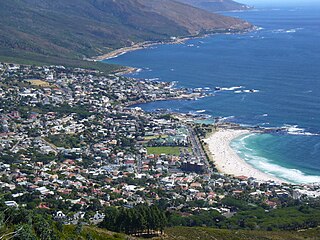
Camps Bay is an affluent suburb of Cape Town, South Africa, and the small bay on the west coast of the Cape Peninsula after which it is named. In summer it attracts many South African and foreign visitors.

<span class="mw-page-title-main">Strand, Western Cape</span> Seaside town in the Western Cape, South Africa

Strand is a seaside resort town in the Western Cape, South Africa. It forms part of the Helderberg region of the City of Cape Town Metropolitan Municipality, situated on the north-eastern edge of False Bay and near the foot of the Helderberg Mountains. Its geographical position is between Somerset West and Gordon's Bay, and is about 50 km southeast of Cape Town City Bowl. Strand has a population of approximately 50,000. Strand's main attraction is the beach; 5 km of white sandy beach off False Bay.

<span class="mw-page-title-main">Muizenberg</span> Coastal town in the Western Cape, South Africa

Muizenberg is a beach-side town in the Western Cape, South Africa. It is situated where the shore of the Cape Peninsula curves round to the east on the False Bay coast. It is considered to be the main surfing spot in Cape Town and is currently home to a surfing community, centered on the popular 'Surfer's Corner'.

<span class="mw-page-title-main">Hartenbos</span> Place in Western Cape, South Africa

Hartenbos is a town in the Western Cape province of South Africa. It is located some 45 kilometres outside George, South Africa. It belongs, together with 20 other settlements, to the Mossel Bay Local Municipality. Originally a farm, the South African Railways and Harbours turned it into a holiday resort for their lower-rung employees in 1933.

<span class="mw-page-title-main">Helderberg</span> Region of the City of Cape Town, South Africa

Helderberg refers to a planning district of the City of Cape Town metropolitan municipality, the mountain after which it is named, a wine-producing area in the Western Cape province of South Africa, or a small census area in Somerset West.

<span class="mw-page-title-main">Cape Poge Wildlife Refuge</span>

Cape Poge Wildlife Refuge is a wildlife refuge on Chappaquiddick Island owned and managed by The Trustees of Reservations. The refuge consists of 516 acres (2.09 km2) and includes the 1893 Cape Poge Lighthouse.

Cannon Rocks is a small seaside town on the Indian Ocean in the Eastern Cape Province, South Africa, between Boknes and the boundary of the Greater Addo Elephant Park. It is situated 135 km east of Port Elizabeth and 180 km west of East London approximately 15 minutes from the town of Kenton-on-Sea. Port Alfred is approximately 40 km to the East of Cannon Rocks via the R72 Road. Cannon Rocks is part of the Ndlambe Local Municipality in the Sarah Baartman District of the Eastern Cape.

Boggomsbaai is a coastal holiday village in Mossel Bay Municipality in the Western Cape province of South Africa.

Dana Bay can really be considered as a sort of village with a mini supermarket, bakery, butchery, eating establishments, fuel station and liquor outlets amongst other small businesses and forms part of the greater Mossel Bay municipality. The village forms the west boundary of the Garden Route District, Western Cape, South Africa. Dana Bay lies approximately halfway between Port Elizabeth and Cape Town and is a mere 4 kilometers off the N2 highway. The central part of Mossel Bay is about 12 kilometers from Dana Bay.

Gouritsmond is a small South African tourist town in the municipality of Hessequa, Garden Route District, Western Cape Province. It is situated about 36 road kilometres south-east of Albertinia. Gouritsmond is located just on the west side of the Gouritz River estuary and on the Indian Ocean. In 2011, Gouritsmond had 515 inhabitants in 206 households.

<span class="mw-page-title-main">Great Brak River (town)</span> Place in Western Cape, South Africa

Great Brak River is a coastal village in the Mossel Bay Local Municipality in the Western Cape province of South Africa. It is a historic village built around the lagoon of the Great Brak River, 17 kilometres (11 mi) north-northeast of the town of Mossel Bay.

<span class="mw-page-title-main">Mossel Bay Yacht and Boat Club</span>

Mossel Bay Yacht and Boat Club, / Mosselbaai Seiljag- en Bootklub (Afrikaans), established in 1956, was a yacht club in South Africa. It is located in the harbour city of Mossel Bay on the Garden Route in the Western Cape Province.

<span class="mw-page-title-main">St Francis Bay</span> Place in Eastern Cape, South Africa

St Francis Bay is a holiday town in Sarah Baartman District Municipality in the Eastern Cape province of South Africa, roughly one hour’s drive from Gqeberha.

<span class="mw-page-title-main">Morgan Bay</span> Place in Eastern Cape, South Africa

Morgan Bay is a village in Amathole District Municipality in the Eastern Cape province of South Africa.

References

  1. 1 2 3 4 "Main Place Vleesbaai". Census 2011.
  2. Stimie, C.M., Joubert, J.J.F., Marais, A.N., Scheffler, Helena. 1988. Vleesbaai 500 – Die storie van ’n Boerestrand.
  3. http://www.vleesbaai.co.za Date accessed: 13 March 2013
  4. http://www.wannasurf.com/spot/Africa/South_Africa/South_Garden_Route/vleesbaai/ Date accessed: 13 March 2013
  5. http://www.oystercatchertrail.co.za/oystercatcher.htm Date accessed: 13 March
  6. http://www.4x4ineden.co.za/routes.php?action=show_route&route=vleesbay Date accessed: 13 March 2013