Packwood, Washington

Last updated

Packwood, Washington
Nisqually Glacier 0900.JPG
From Packwood, Mount Rainier and Butter Creek Canyon dominate the view to the north.
Lewis County Washington Incorporated and Unincorporated areas Packwood Highlighted.svg
Location of Packwood in Lewis County, WA
Coordinates: 46°36′14″N121°40′40″W / 46.60389°N 121.67778°W / 46.60389; -121.67778
Country United States
State Washington
County Lewis
Area
  Total1.00 sq mi (2.58 km2)
  Land1.00 sq mi (2.58 km2)
  Water0.0 sq mi (0.0 km2)
Elevation
1,053 ft (321 m)
Population
 (2020) [1]
  Total319
  Density343/sq mi (132.4/km2)
Time zone UTC−8 (PST)
  Summer (DST) UTC−7 (PDT)
ZIP code
98361
Area code 360
GNIS feature ID1524132 [2]
FIPS code 53-52600

Packwood is an unincorporated community and census-designated place (CDP) located in easternmost Lewis County, Washington, in the United States. As of the 2020 census, the CDP had a population of 319, while the town and surrounding Packwood community (east of Cora Bridge) had a total population of 1,073. [3]

Contents

Etymology

Packwood was originally established as Sulphur Springs. Shortly thereafter, it was renamed to Lewis, [4] in honor of Meriwether Lewis, but was finally renamed to Packwood, in honor of William Packwood due to the US Postal Service confusing the town with Fort Lewis.[ citation needed ]

History

The name "Packwood", used for the town, a mountain pass, and a lake, honors William Packwood, a Virginian pioneer and explorer of Oregon and Washington. [5] Packwood and James Longmire were tasked by the Washington Territorial Legislature to chart a low pass over the Cascade Range, this necessitated by the deaths of several delegates in their journey to the first legislative session. As a mark of their successes in this venture, the charted pass - called the Packwood Saddle - is still unused by any road, trail, or other conveyance to pass between the east and west sides of the Cascades. Packwood is home to the historic Packwood Ranger Station located off of US-12. [6]

Packwood suffered severe flooding during an excessive rain and snowmelt event in December 1977. Eight homes were washed away and evacuations were necessary. [7] [8] Several bridges were closed after either washouts or structural damages, cutting of Packwood. The Johnson Creek Bridge, located on the main arterial of White Pass Scenic Byway, collapsed. [9] [10] The community was inundated again during a November 2006 flood necessitating evacuations of hundreds of people from the High Valley area after a dike broke. Washed out homes were carried away by the Cowlitz River, which was recorded as exceeding 10 feet (3.0 m); the powerful flood changed the course of the river. [11] [12]

Geography

Packwood is located at 46°36′14″N121°40′40″W / 46.60389°N 121.67778°W / 46.60389; -121.67778 (46.6040008, -121.6778664), [13] at the intersection of US Highway 12 and Gifford Pinchot National Forest Road 52 (Skate Creek Road). It is located between Mount Rainier National Park to the north and Mt. St. Helens National Volcanic Monument to the south. The Tatoosh Wilderness, Goat Rocks Wilderness, and William O. Douglas Wilderness are to the north, southeast, and northeast respectively, with the Gifford Pinchot National Forest as a buffer in all directions. Packwood is located in the upper Cowlitz River valley, just downstream of the confluence of the Muddy and Clear forks of the Cowlitz. The White Pass Ski Area and crest of the Cascade Range demark the eastern edge of the Packwood area, the town of Randle the west, and large expanses of forest, wilderness, and parkland the north and south.

According to the U.S. Census Bureau, the Packwood CDP has an area of 1.0 square mile (2.6 km2), all of it recorded as land. [14] The larger Packwood area, including the residential communities of Goat Rocks, High Valley Park, Packwood Heights, Skate Creek Terrace, Skyline, and Timberline Village, has 1,073 full-time residents. [3]

Climate

According to the Köppen Climate Classification system, Packwood has a warm-summer Mediterranean climate, abbreviated "Csb" on climate maps. [15]

Climate data for Packwood
MonthJanFebMarAprMayJunJulAugSepOctNovDecYear
Record high °F (°C)67
(19)
77
(25)
85
(29)
90
(32)
102
(39)
104
(40)
108
(42)
105
(41)
105
(41)
97
(36)
75
(24)
63
(17)
108
(42)
Mean daily maximum °F (°C)42.9
(6.1)
48.1
(8.9)
52.6
(11.4)
59
(15)
66.3
(19.1)
71.6
(22.0)
79
(26)
79.1
(26.2)
73.9
(23.3)
61.9
(16.6)
48.4
(9.1)
42.3
(5.7)
60.4
(15.8)
Mean daily minimum °F (°C)29.3
(−1.5)
30.5
(−0.8)
32.8
(0.4)
36.5
(2.5)
41.8
(5.4)
47.4
(8.6)
51
(11)
50.7
(10.4)
44.7
(7.1)
38.5
(3.6)
33.3
(0.7)
29.8
(−1.2)
38.9
(3.8)
Record low °F (°C)−9
(−23)
−2
(−19)
2
(−17)
20
(−7)
20
(−7)
27
(−3)
28
(−2)
29
(−2)
23
(−5)
17
(−8)
−3
(−19)
−8
(−22)
−9
(−23)
Average precipitation inches (mm)9.01
(229)
6
(150)
5.31
(135)
3.39
(86)
2.54
(65)
2.08
(53)
0.72
(18)
1.06
(27)
2.24
(57)
4.88
(124)
8.87
(225)
9.05
(230)
55.14
(1,401)
Average snowfall inches (cm)11.8
(30)
4.7
(12)
2.8
(7.1)
0.3
(0.76)
0
(0)
0
(0)
0
(0)
0
(0)
0
(0)
0
(0)
1.9
(4.8)
6.4
(16)
27.9
(71)
Average precipitation days (≥ 0.01 inch)171416141210458131717147
Source: [16]

Arts and culture

Historic buildings and sites

Packwood is home to the La Wis Wis Guard Station No. 1165, a rustic cabin built by the Civilian Conservation Corps and is listed on the National Register of Historic Places.

Parks and recreation

Packwood is home to the Skate Creek Park Natural Area. Officially listed as the Washington State Parks Packwood Property, [17] the land is owned by the state though considered surplus. The park is approximately 180 acres (73 ha) in size. Attempts to transfer the parcel to the Lewis County parks department was considered but did not materialize; the county officially passed on the transfer in 2022. [18] [19]

The Cowlitz River Public Access Park opened in 2022, The park lacks a boat ramp but a nature trail allows users to access to the Cowlitz River. [20] The Packwood Ballpark, under the oversight of the Lewis County Public Utility District, hosts a baseball field and open areas. [21]

Economy

The town of Packwood has historically relied on the forest products industry as an economic engine, supplemented by government employment (via the National Forest and Park Services) and seasonal tourism.

In 1998, 220 jobs were lost when the Packwood Lumber Mill closed because of the depressed Pacific Northwest lumber industry. [3] The Packwood Ranger Station closed in 2003 after budget cuts in the US Forest Service and operations for the Cowlitz Valley Ranger District were centralized in nearby Randle. [22] By 2010, the full-time population of Packwood had halved and many residences had become second homes or vacation rentals. [3]

Packwood has become an increasingly popular vacation destination. [3] [23] Proximity to White Pass Ski Area, expanded in 2010 by 767 acres, brings in visitors over the winter and access to Mount Rainier National Park and Gifford Pinchot National Forest brings visitors over the summer. [24] [25] Packwood hosts the Packwood Flea Market, established in the 1970s and now one of largest flea markets in the western United States, every Memorial Day weekend and Labor Day weekend. [26] Local organizations and Lewis County have sought to promote the tourism opportunities of the town, improve tourist and vacation infrastructure, and plan for the long-term economy of the town. [3] Home prices in Packwood increased 300% between 2012 and 2022, posing a challenge for the seasonal employees outdoor recreation relies on. [3]

Government and politics

Politics

Presidential Elections Results - Packwood District
Year Republican Democratic Third parties
2020 [27] 52.82%10345.13% 882.06% 4
Presidential Elections Results - Big Bottom District
Year Republican Democratic Third parties
2020 [28] 56.0138741.39% 2862.61% 18

Packwood and the surrounding Big Bottom voting district are recognized as being majority Republican and conservative, though less so in comparison to other rural areas within Lewis County.

The 2020 election included votes for candidates of the Libertarian Party in both districts.

Education

The first school in Packwood was built in 1915 [29] when the community was known as Lewis. Then part of what was considered the largest school district in the United States, it's first class included 11 students. The original schoolhouse was replaced in 1938 with a brick structure that housed an auditorium and in 1953, the Packwood boys' basketball team won the state championship. [4]

Packwood is located in the White Pass School District, which, in addition to Packwood, covers the small towns of Randle and Glenoma and the vast forested expanse in extreme eastern Lewis County, terminating at the crest of the Cascades and the border with Yakima County. [30] In 2004, the town's school-age population dropped to the point that the local K-6 elementary school was shuttered, although in 2007 the building was converted to the White Pass Country Historical Museum and now houses a local museum and hosts community events. [31]

Infrastructure

Packwood is accessible year-round by private vehicle on US 12, and seasonally by SR 123 and several forest service roads. The general aviation Packwood Airport is located three blocks west of highway 12 in downtown Packwood, and L.E.W.I.S. Mountain Highway Transit provided multiple weekday public transportation to Centralia-Chehalis, including connections to Amtrak and Greyhound until it stopped operation in 2021. Lewis County Transit DART still has some operation thru Packwood. [32]

The community is among 8 locations that are part of an EV installation project on the White Pass Scenic Byway. The program will stretch from the White Pass Ski Area to Chehalis and is run in partnership with Lewis County PUD, Twin Transit, state government agencies, and local community efforts. The venture began in 2023 from two grants totaling over $1.8 million. [33]

Related Research Articles

<span class="mw-page-title-main">Lewis County, Washington</span> County in Washington, United States

Lewis County is a county in the U.S. state of Washington. As of the 2020 census, the county's population was 82,149. The county seat is Chehalis, and its largest city is Centralia. Lewis County comprises the Centralia, WA Micropolitan Statistical Area, which is also included in the Seattle-Tacoma, WA Combined Statistical Area.

<span class="mw-page-title-main">Cowlitz County, Washington</span> County in Washington, United States

Cowlitz County is a county located in the U.S. state of Washington. As of the 2020 census, its population was 110,730. The county seat is Kelso, and its largest city is Longview. The county was formed in April 1854. Its name derives from the anglicized version of the Cowlitz Indian term Cow-e-liske, meaning either 'river of shifting sands' or 'capturing the medicine spirit.' Cowlitz comprises the Longview, WA Metropolitan statistical area, which is also included in the Portland-Vancouver-Salem, OR-WA Combined statistical area.

<span class="mw-page-title-main">Morton, Washington</span> City in Washington, United States

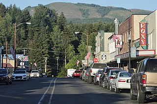
Morton is a city in Lewis County, Washington, United States. The population was 1,036 at the 2020 census.

<span class="mw-page-title-main">Cowlitz River</span> River in Washington, United States

The Cowlitz River is a river in the state of Washington in the United States, a tributary of the Columbia River. Its tributaries drain a large region including the slopes of Mount Rainier, Mount Adams, and Mount St. Helens.

Randle is a small town in eastern Lewis County, Washington, United States. Randle is located on U.S. Route 12 and is notable as the northeastern access point to the Mount St. Helens Windy Ridge viewpoint, by way of forest service roads that cut through the Gifford Pinchot National Forest.

<span class="mw-page-title-main">Gifford Pinchot National Forest</span> Protected area in the state of Washington, United States

Gifford Pinchot National Forest is a National Forest located in southern Washington, managed by the United States Forest Service. With an area of 1.32 million acres (5300 km2), it extends 116 km (72 mi) along the western slopes of Cascade Range from Mount Rainier National Park to the Columbia River. The forest straddles the crest of the South Cascades of Washington State, spread out over broad, old growth forests, high mountain meadows, several glaciers, and numerous volcanic peaks. The forest's highest point is at 12,276 ft (3,742 m) at the top of Mount Adams, the second tallest volcano in the state after Rainier. Often found abbreviated GPNF on maps and in texts, it includes the 110,000-acre (450 km2) Mount St. Helens National Volcanic Monument, established by Congress in 1982.

<span class="mw-page-title-main">Goat Rocks</span> Extinct stratovolcano in United States of America

Goat Rocks is an extinct stratovolcano in the Cascade Range, located between Mount Rainier and Mount Adams in southern Washington, in the United States. Part of the Cascade Volcanoes, it was formed by the subduction of the Juan de Fuca Plate under the western edge of the North American Plate. The volcano was active from 3.2 million years ago until eruptions ceased between 1 and 0.5 million years ago. Throughout its complex eruptive history, volcanism shifted from silicic explosive eruptions to voluminous, mafic activity.

<span class="mw-page-title-main">Goat Rocks Wilderness</span> Protected area

Goat Rocks Wilderness is a U.S. wilderness area in Washington, United States, comprising 108,096 acres (43,745 ha) of Okanagan–Wenatchee National Forest and Gifford Pinchot National Forest on the crest of the Cascade Range south of U.S. Highway 12. Its central feature is a number of rugged peaks, the Goat Rocks, that are named after the numerous mountain goats that live in the area.

<span class="mw-page-title-main">Cispus River</span> River in Washington, United States

The Cispus River is about 54 miles (87 km) long and flows into the Cowlitz River at Lake Scanewa in the Cascade Range of Washington. Its tributaries drain most of south-central and southeastern Lewis County, extreme northeast Skamania County, and some of western Yakima County.

Glenoma is an unincorporated community in Lewis County located off U.S. Route 12, between the towns of Morton and Randle. The area is northeast of Riffe Lake.

<span class="mw-page-title-main">Salkum, Washington</span> Unincorporated community in Washington, United States

Salkum is a rural unincorporated community in Lewis County, Washington. The town is located on U.S. Route 12 and is 2.1 miles (3.4 km) west of Silver Creek.

<span class="mw-page-title-main">Washington State Route 503</span> Highway in Washington

State Route 503 (SR 503) is a 54.11-mile-long (87.08 km) state highway serving Clark and Cowlitz counties in the U.S. state of Washington. The highway travels north from a short concurrency with SR 500 in Orchards through Battle Ground, the eastern terminus of SR 502, and communities in rural Clark County before crossing the Lewis River on the Yale Bridge. SR 503 intersects its spur route and turns west to parallel the Lewis River downstream to Woodland, where the highway ends at an interchange with Interstate 5 (I-5). The highway was part of the Lewis River Road, signed as State Road 15, from 1909 until 1919. The current route of SR 503 was split between Secondary State Highway 1S (SSH 1) from Woodland to Battle Ground and SSH 1U from Battle Ground to Orchards in 1937, combined to form SR 503 during the 1964 highway renumbering. A spur route, established in 1991, travels northeast into the Gifford Pinchot National Forest along Yale Lake, serving the community of Cougar.

<span class="mw-page-title-main">Naches River</span> River in the United States of America

The Naches River is a tributary of the Yakima River in central Washington in the United States. Beginning as the Little Naches River, it is about 75 miles (121 km) long. After the confluence of the Little Naches and Bumping River the name becomes simply the Naches River. The Naches and its tributaries drain a portion of the eastern side of the Cascade Range, east of Mount Rainier and northeast of Mount Adams. In terms of discharge, the Naches River is the largest tributary of the Yakima River.

<span class="mw-page-title-main">U.S. Route 12 in Washington</span> Section of U.S. Highway in Washington, United States

U.S. Route 12 is a major east–west U.S. Highway, running from Aberdeen, Washington, to Detroit, Michigan. It spans 430.5 miles (692.8 km) across the state of Washington, making it the second longest highway in the state. It is also the only numbered highway to span the entire state from west to east, starting near the Pacific Ocean, and crossing the Idaho state line near Clarkston. It crosses the Cascade Range over White Pass, south of Mount Rainier National Park. Portions of it are concurrent with Interstate 5 (I-5) and Interstate 82 (I-82), although the majority of the route does not parallel any interstate highway.

The Green River is the largest tributary of the North Fork Toutle River in the U.S. state of Washington. Situated near Mount St. Helens in the Cascade Range in the southern part of the state, it flows generally west through Mount St. Helens National Volcanic Monument and industrial timberlands for 37.4 miles (60.2 km). The river drains more than 130 square miles (340 km2) in parts of three Washington counties: Skamania, Lewis, and Cowlitz.

<span class="mw-page-title-main">Cowlitz Falls Dam</span> Dam in Lewis County, Washington

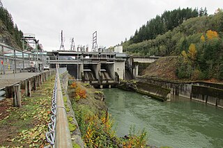
Cowlitz Falls Dam is a 70 megawatt hydroelectric dam in Lewis County, Washington. It was constructed in the early 1990s and completed in 1994. The dam is 140 feet (43 m) high and 700 feet (210 m) wide.

<span class="mw-page-title-main">Takhlakh Lake</span>

Takhlakh Lake is a lake situated 7.3 miles (11.7 km) northwest of Mount Adams in the U.S. state of Washington. It is fed by a few small unnamed inflow creeks originating near Takh Takh Meadows, tributary to the Cispus River. A popular 53-site campground on the west side of the lake brings summer and early fall campers as well as hikers hiking the Takhlakh Loop Trail and the Takh Takh Meadows Trail, and nearby trails in the Mount Adams Wilderness. A day use area offers a picnic area and provides a boat ramp as well. The lake is one of the five lakes, all within a seven-mile radius, in the Midway High Lakes Area. It is managed by the Gifford Pinchot National Forest.

<span class="mw-page-title-main">Olallie Lake (Skamania County, Washington)</span>

Olallie Lake is an alpine lake and one of several in the area fed by streams coming off the glaciers from nearby Mount Adams. A small, but popular Olallie Lake Campground offers scenic camping as well as non-motorized boating and fishing experiences. It is located at 4,200 feet elevation in the Gifford Pinchot National Forest, in Washington state.

The Packwood Airport is a single runway, public general aviation airport, 3 blocks west of US Highway 12 in downtown Packwood, Washington. No commercial service uses the airport, and flight operations are predominantly private, with search-and-rescue and wildfire control operations in the Gifford Pinchot National Forest and Mount Rainier National Park a significant secondary usage. Due to the presence of nearby trees and hillsides to the north of the airport, current plans for the airport are to remove the northern 146 ft (45 m), and add at least a corresponding length to the south end of the runway. It is one of four airports owned and operated by Lewis County, Washington.

Cora was a former farming community and is a locale in Lewis County, Washington, United States. Cora is located off U.S. Route 12, next to the Cowlitz River between the towns of Randle and Packwood.

References

  1. "Packwood CDP population". United States Census Bureau. Retrieved January 28, 2024.
  2. "Packwood". Geographic Names Information System . United States Geological Survey, United States Department of the Interior.
  3. 1 2 3 4 5 6 7 "Packwood Subarea Plan: Ordinance 1350". Lewis County, Washington. Retrieved January 28, 2024.
  4. 1 2 "First School In Packwood Had 11 Pupils". The Centralia Daily Chronicle. June 6, 1953. p. 14C. Retrieved June 4, 2024.
  5. Meany, Edmond S. (1921). "Origin of Washington Geographic Names". The Washington Historical Quarterly. XII. Washington University State Historical Society: 65. Retrieved June 11, 2009.
  6. Nile, Amy (September 5, 2012). "Packwood's Old Ranger Station Has a New Use". The Chronicle. Retrieved January 28, 2024.
  7. Blomdahl, George (December 6, 1977). "Rain bringing fresh worries to east county". The Daily Chronicle. p. 1. Retrieved May 23, 2024.
  8. Zander, Larry (December 2, 1977). "Mudslides isolate east county area". The Daily Chronicle. p. 1. Retrieved May 23, 2024.
  9. Benowitz, Sam (December 3, 1977). "East county hit hard by rampaging rivers". The Daily Chronicle. p. 1. Retrieved May 23, 2024.
  10. "County's flood toll may cost $6 million dollars". The Daily Chronicle (Centralia, Washington). December 5, 1977. p. 1. Retrieved May 23, 2024.
  11. Eric Olson; Aaron VanTuyl (November 8, 2006). "High Valley evacuees may return home". The Chronicle. p. A9. Retrieved May 23, 2024.
  12. VanTuyl, Aaron (November 9, 2006). "Homeowners pick up the pieces". The Chronicle. pp. A1, A8. Retrieved May 23, 2024.
  13. "US Gazetteer files: 2010, 2000, and 1990". United States Census Bureau. February 12, 2011. Retrieved April 23, 2011.
  14. "2020 U.S. Gazetteer Files –Washington". United States Census Bureau. Retrieved March 5, 2021.
  15. Climate Summary for Packwood, Washington
  16. "PACKWOOD, WASHINGTON (456262)". Western Regional Climate Center. Retrieved November 15, 2015.
  17. "Skate Creek Park". Packwood Visitor Center. Retrieved April 22, 2024.
  18. Rosane, Eric (January 26, 2022). "Deal Would Transfer 180 Acres of State Park Land to Lewis County". The Chronicle. Retrieved April 22, 2024.
  19. Vander Stoep, Isabel (April 6, 2022). "Lewis County Backs Out of Skate Creek Park Acquisition". The Chronicle. Retrieved April 22, 2024.
  20. Vander Stoep, Isabel (June 8, 2022). "Lewis County Soft Opens Cowlitz River Public Access Park". The Chronicle. Retrieved April 22, 2024.
  21. "LCPUD - Packwood Ballpark". Lewis County Public Utility District. October 11, 2023. Retrieved April 22, 2024.
  22. Thomas, Allen (November 13, 2003). "Wind River visitor center closing for good". The Columbian. Retrieved January 28, 2024.
  23. Yaw, Claudia (November 30, 2020). "New Tourism Commission Will Create Countywide Strategic Plan". The Chronicle. Retrieved January 28, 2024.
  24. Hill, Craig. "Long-awaited White Pass ski area expansion opens today". The Olympian. Retrieved January 28, 2024.
  25. "About Packwood". Packwood Visitor Center.
  26. Miller, Ashley. "Packwood Flea Market: A Hub for Antiquers and Crafters Alike". Flea Market Insiders. Retrieved January 28, 2024.
  27. "Lewis County 2020 Election". Results.Vote.WA. Retrieved July 23, 2021.
  28. "Lewis County November 3, 2020 General Election". vote.wa.gov. Washington Secretary of State. Retrieved August 20, 2021.
  29. "New Schools Authorized". The Daily Chronicle-Examiner. March 10, 1915. p. 1. Retrieved June 4, 2024.
  30. "About Us". White Pass School District. Retrieved January 28, 2024.
  31. "White Pass Historical Museum Opens". The Chronicle. Retrieved January 28, 2024.
  32. "LEWIS Mountain Highway Transit map" (PDF). White Pass Community Services Coalition.
  33. The Chronicle staff (March 7, 2023). "Construction Begins on U.S. Highway 12 Electric Vehicle Charging Station Network". The Chronicle (Centralia, Washington). Retrieved June 21, 2023.