Related Research Articles

Maries County is a county located in the U.S. state of Missouri. As of the 2020 census, its population was 8,432. Its county seat is Vienna. The county was organized March 2, 1855 and named for the Maries River and Little Maries River. The word "Maries" is derived from the French word marais, which means "marsh, lake, or pond".
High Gate is an unincorporated community in eastern Maries County, Missouri, United States. It is at the intersection of routes H and U approximately fourteen miles east of Vienna and 1.5 miles from the Maries-Gasconade county line.

Hayden is an unincorporated community in southern Maries County, Missouri, United States. The community is located on Missouri Route E between Big Bend and Stickney. It is eight miles south of Vienna and approximately sixteen miles northwest of Rolla.
Rich Fountain is an unincorporated community in Osage County, Missouri, United States. It is located approximately three miles east of U.S. Route 63 and is fifteen miles southeast of Jefferson City.
Marys Home is an unincorporated community in northern Miller County, in the U.S. state of Missouri. The community is on Missouri Route H, approximately two miles north of the Osage River. The town of Eugene in the southwest corner of Cole County is about four miles to the northwest, by Route H and Missouri Route 17.
Bachelor is an unincorporated community in northern Callaway County, in the U.S. state of Missouri. The community is on Missouri Route A, approximately six miles east-southeast of Auxvasse. The headwaters of Bachelor Creek are to the northwest of the community.
Hinch is an unincorporated community in eastern Crawford County, in the U.S. state of Missouri.
Oak Hill is an unincorporated community in northwest Crawford County, in the U.S. state of Missouri. The community is located on the east bank of Brush Creek, one-quarter mile south of the Crawford-Gasconade county line and is on Missouri Route CC, one mile east of Missouri Route 19.
Roy is an unincorporated community in southwestern Douglas County, Missouri, United States. Roy is located on Missouri Route 76, south of the Goodhope junction on Missouri Route T. The village site is at an elevation of 1,263 ft (385 m) about 1.5 mile west of the Beaver Creek valley.
Dissen is an unincorporated community in western Franklin County, in the U.S. state of Missouri. The community is located on the north side of Boeuf Creek along Missouri Route Y and four miles southwest of New Haven.
Kiel is an unincorporated community in northwest Franklin County, in the U.S. state of Missouri.
Bend is an unincorporated community in northeastern Maries County, in the U.S. state of Missouri.
Lanes Prairie is an unincorporated community in eastern Maries County, in the U.S. state of Missouri.
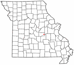
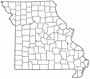
Lois is an unincorporated community in eastern Maries County, in the U.S. state of Missouri.
Safe is an unincorporated community in southeastern Maries County, in the U.S. state of Missouri. The community is located on Missouri Route H on a hill just west of and above the Bourbeuse River. The community is approximately six miles north-northeast of St. James.
Stickney is an unincorporated community in southern Maries County, in the U.S. state of Missouri. The community is on Missouri Route E, two miles east of Hayden. The location is just west of the confluence of Dry Creek and Montague Creek and two miles west of the confluence of Dry Creek with the Gasconade River. The community is about eight miles south of Vienna.
Freedom is an unincorporated community in Osage County, in the U.S. state of Missouri. The village lies on Missouri Route N, approximately one mile north of U.S. Route 50 and two miles north of the Gasconade River.
Gascondy is an extinct town in southern Osage County, in the U.S. state of Missouri. The GNIS classifies it as a populated place.
Althea is an extinct town in eastern Ozark County, in the Ozarks of southern Missouri, United States. The GNIS classifies it as a populated place. The location is on the North Fork River at the crossing of Missouri Route H, at an elevation of 623 feet. It is approximately five miles northeast of Tecumseh.
Royal is an unincorporated community in northeastern Phelps County, in the U.S. state of Missouri. The community is on Missouri Route B, approximately eight miles north of St. James.
References
- ↑ U.S. Geological Survey Geographic Names Information System: Paydown, Missouri
- ↑ Missouri Atlas & Gazetteer, DeLorme, 1st ed., 1998, p. 46 ISBN 0899332242
- ↑ Earngey, Bill (1995). Missouri Roadsides: The Traveler's Companion. University of Missouri Press. p. 13. ISBN 9780826210210.
- ↑ "Maries County Place Names, 1928–1945". The State Historical Society of Missouri. Archived from the original on June 24, 2016. Retrieved November 2, 2016.
- ↑ "Post Offices". Jim Forte Postal History. Retrieved November 2, 2016.
Municipalities and communities of Maries County, Missouri, United States | ||
|---|---|---|
| Cities |  | |
| Village | ||
| Townships | ||
| Unincorporated communities | ||
| Ghost town | ||
| Footnotes | ‡This populated place also has portions in an adjacent county or counties | |
38°13′44″N91°48′14″W / 38.22889°N 91.80389°W
| | This Maries County, Missouri state location article is a stub. You can help Wikipedia by expanding it. |