Pfalzgrafenstein CastleBurg Pfalzgrafenstein with Burg Gutenfels in the background, about 1900
Pfalzgrafenstein Castle (German: Burg Pfalzgrafenstein) is a toll castle on the Falkenau island, otherwise known as Pfalz Island in the River Rhine near Kaub, Germany. Known as "the Pfalz", this former stronghold is famous for its picturesque and unique setting.
The keep of this island castle, a pentagonal tower with its point upstream, was erected between 1326 and 1327 by King Ludwig the Bavarian. Around the tower, a defensive hexagonal wall was built between 1338 and 1340. In 1477 Pfalzgrafenstein was passed as deposit to the Count of Katzenelnbogen.[1] Later additions were made in 1607 and 1755, consisting of corner turrets, the gun bastion pointing upstream, and the characteristic baroque tower cap.
The castle functioned as a toll-collecting station that was not to be ignored. It worked in concert with Gutenfels Castle and the fortified town of Kaub on the right side of the river. Due to a dangerous cataract on the river's left, about a kilometer upstream, every vessel would have to use the fairway nearer to the right bank, thus floating downstream between the mighty fortress on the vessel's left and the town and castle on its right. A chain across the river drawn between those two fortifications forced ships to submit, and uncooperative traders could be kept in the dungeon until a ransom was delivered. The dungeon was a wooden float in the well.
Unlike the vast majority of Rhine castles, "the Pfalz" was never conquered or destroyed, withstanding not only wars, but also the natural onslaughts of ice and floods by the river. Its spartan quarters held about twenty men.
Extensive measures of waterway engineering in the nineteenth century, above all straightening the river for better use as an international waterway and along this particular stretch, clearing it from the old cataract, relocated the regularly used fairway from the river's right arm to its left. Thus the tactical advantage may not be apparent to one unaware of the change in the watercourse.
The island of the castle was used for the Rhine crossing by 60,000 Prussian troops under Blücher in the winter of 1814 in his pursuit of Napoleon.
"A ship of stone..."
The castle was acquired by Prussia in 1866, and toll collections ceased in 1867. It continued to be used as a signal station for the river boat traffic for about another century. In 1946, the castle became the property of the State of Rhineland-Palatinate.
Museum
The State eventually turned "the Pfalz" into a museum and restored the color scheme of the baroque period. The museum reflects the conditions of the 14th century, and the visitor will not find modern amenities such as electricity or a lavatory. It is accessible to the public via a ferry service from nearby Kaub as long as river conditions permit.
Bacharach is a town in the Mainz-Bingen district in Rhineland-Palatinate, Germany. It belongs to the Verbandsgemeinde of Rhein-Nahe, whose seat is in Bingen am Rhein, although that town is not within its bounds.
The Neckar is a 362-kilometre-long (225 mi) river in Germany, mainly flowing through the southwestern state of Baden-Württemberg, with a short section through Hesse. The Neckar is a major right tributary of the Rhine. Rising in the Schwarzwald-Baar-Kreis near Schwenningen in the Schwenninger Moos conservation area at a height of 706 m (2,316 ft) above sea level, it passes through Rottweil, Rottenburg am Neckar, Kilchberg, Tübingen, Wernau, Nürtingen, Plochingen, Esslingen, Stuttgart, Ludwigsburg, Marbach, Heilbronn and Heidelberg, before discharging on average 145 m3/s (5,100 cu ft/s) of water into the Rhine at Mannheim, at 95 m (312 ft) above sea level, making the Neckar its 4th largest tributary, and the 10th largest river in Germany. Since 1968, the Neckar has been navigable for cargo ships via 27 locks for about 200 kilometres (120 mi) upstream from Mannheim to the river port of Plochingen, at the confluence with the Fils.
The Lahn is a 245.6-kilometre-long (152.6 mi), right tributary of the Rhine in Germany. Its course passes through the federal states of North Rhine-Westphalia (23.0 km), Hesse (165.6 km), and Rhineland-Palatinate (57.0 km).
Katzenelnbogen is the name of a castle and small town in the district of Rhein-Lahn-Kreis in Rhineland-Palatinate, Germany. Katzenelnbogen is the seat of the Verbandsgemeinde Aar-Einrich.
Zwingenberg lies in the Bergstraße district in southern Hessen, Germany, south of Frankfurt and Darmstadt, and with the granting of town rights coming in 1274 it is the oldest town on the Hessen Bergstraße.
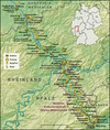
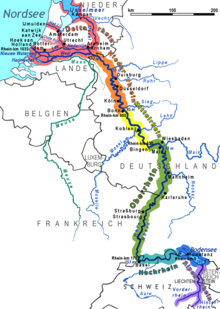
The Rhine Gorge is a popular name for the Upper Middle Rhine Valley, a 65 km section of the Rhine between Koblenz and Rüdesheim in the states of Rhineland-Palatinate and Hesse in Germany. It was added to the UNESCO list of World Heritage Sites in June 2002 because of its beauty as a cultural landscape, its importance as a route of transport across Europe, and the unique adaptations of the buildings and terraces to the steep slopes of the gorge.
Sankt Goar is a town on the west bank of the Middle Rhine in the Rhein-Hunsrück-Kreis (district) in Rhineland-Palatinate, Germany. It belongs to the Verbandsgemeinde Hunsrück-Mittelrhein, whose seat is in Emmelshausen.
Sankt Goarshausen is a town located in the Rhein-Lahn-Kreis in Nassau on the eastern shore of the Rhine, in the section known as the Rhine Gorge, directly across the river from Sankt Goar, in the German state Rhineland-Palatinate. It is located within the Nassau Nature Park and the Rhine Gorge UNESCO world heritage site, and was historically part of the Duchy of Nassau. It lies approximately 30 km south of Koblenz, and it is above all famous for the Lorelei rock nearby. Sankt Goarshausen is the seat of the Loreley collective municipality. The town's economy is based on wine making and tourism.
Lahnstein is a verband-free town of Rhein-Lahn-Kreis in Rhineland-Palatinate, Germany. It is situated at the confluence of the Lahn with the Rhine, approximately 6 kilometres (3.7 mi) south of Koblenz. Lahnstein was created in 1969 by the merger of the previously independent towns of Oberlahnstein on the south side of the Lahn and Niederlahnstein on the north side. In 2020, it had a population of 18,030.
Between Bingen and Bonn, Germany, the river Rhine flows as the Middle Rhine through the Rhine Gorge, a formation created by erosion, which happened at about the same rate as an uplift in the region, leaving the river at about its original level, and the surrounding lands raised. This gorge is quite deep, about 130 metres (430 ft) from the top of the rocks down to the average water-line.
Kaub is a town in Germany, state Rhineland-Palatinate, district Rhein-Lahn-Kreis. It is part of the municipality (Verbandsgemeinde) Loreley. It is located on the right bank of the Rhine, approx. 50 km west from Wiesbaden. It is connected to Wiesbaden and Koblenz by railway. It has a Roman Catholic and an Evangelical church, and a statue of General Blücher. Historically, trade mainly consisted of the wines of the district.
Maus Castle is a castle above the village of Wellmich in Rhineland-Palatinate, Germany. It lies on the east side of the Rhine, north of Katz Castle in Sankt Goarshausen and opposite Rheinfels Castle at Sankt Goar across the river.
Rheinfels Castle is a castle ruin located above the left (west) bank of the Rhine in Sankt Goar, Germany. It was started in 1245 by Count Diether V of Katzenelnbogen. After expansions, it was the largest fortress in the Middle Rhein Valley between Koblenz and Mainz. It was slighted by French Revolutionary Army troops in 1797. It is the largest castle overlooking the Rhine, and historically covered five times its current area.
The County of Katzenelnbogen was an immediate state of the Holy Roman Empire. It existed between 1095 and 1479, when it was inherited by the Landgraves of Hesse.
Stolzenfels Castle is a former medieval fortress castle ("Burg") turned into a palace, near Koblenz on the left bank of the Rhine, in the state of Rhineland-Palatinate, Germany. Stolzenfels was a ruined 13th-century castle, gifted to the Prussian crown prince, Frederick William in 1823. He had it rebuilt as a 19th-century palace in Gothic Revival style. Today, it is part of the UNESCO World Heritage Site Upper Middle Rhine Valley.
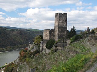
Gutenfels Castle, also known as Caub Castle, is a castle 110m above the town of Kaub in Rhineland-Palatinate, Germany.
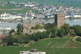
Klopp Castle is a castle in the town of Bingen am Rhein in the Upper Middle Rhine Valley in Rhineland-Palatinate, Germany. In the nineteenth century, the bergfried from the original medieval fortified castle was restored and a new building added which houses the town's administration.
The road toll was a historical fee charged to travellers and merchants in return for permission to use the roads and waterways of the country or state concerned. It was reinforced in the Holy Roman Empire by the law of Straßenzwang which meant that traders in certain goods had to use specified roads. In return, they were usually guaranteed safe passage under the right of escort or Geleitrecht. The road toll was widespread especially in medieval times, and, in addition to the payments from the staple rights, was an important source of income.
Namedy Castle is located in the Rhine valley, close to the village of Namedy in Andernach, Germany. Late gothic, moated castle originally belonging to the Husmann Knights of Andernach.
The Kaub gauging station is a stream gauge located on the Rhine river in the German city of Kaub. It is a "decisive" water level measurement site for the Rhine, as Kaub is located at the shallowest part of the Middle Rhine and ships with freight from North Sea ports have to pass Kaub on their way to the industrial southwest of Germany. The gauge level does not directly correspond to the actual depth of the river ; instead, as is the case with most Rhine gauges, the actual depth of the navigation channel is defined as:
This page is based on this Wikipedia article Text is available under the CC BY-SA 4.0 license; additional terms may apply. Images, videos and audio are available under their respective licenses.