Related Research Articles

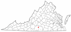
Pittsylvania County is a county located in the Commonwealth of Virginia. As of the 2020 census, the population was 60,501. Chatham is the county seat.
Penhook is a census-designated place (CDP) in Franklin County, Virginia, United States. The population was 801 at the 2010 census, up from 726 in 2000. It is part of the Roanoke Metropolitan Statistical Area.

Rocky Mount is a town in and the county seat of Franklin County, Virginia, United States. The town is part of the Roanoke Metropolitan Statistical Area, and had a population of 4,903 as of the 2020 census. It is located in the Roanoke Region of Virginia.
Mount Airy is an unincorporated community in northeastern Pittsylvania County, Virginia, United States. Its altitude is 643 feet (196 m), and it is located at 36°56′35″N79°11′32″W, along State Route 40 between Gretna and Brookneal. It is included in the Danville, Virginia Metropolitan Statistical Area.

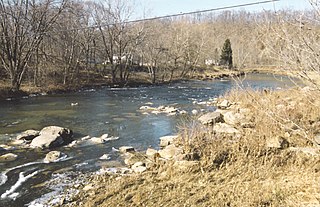
The Roanoke River runs 410 miles (660 km) long through southern Virginia and northeastern North Carolina in the United States. A major river of the southeastern United States, it drains a largely rural area of the coastal plain from the eastern edge of the Appalachian Mountains southeast across the Piedmont to Albemarle Sound. An important river throughout the history of the United States, it was the site of early settlement in the Virginia Colony and the Carolina Colony. An 81-mile (130 km) section of its lower course in Virginia between the Leesville Lake and Kerr Lake is known as the Staunton River, pronounced, as is the Shenandoah Valley city of that name. It is impounded along much of its middle course to form a chain of reservoirs.
The Buckhannon River is a 45.4-mile-long (73.1 km) tributary of the Tygart Valley River in north-central West Virginia, USA. Via the Tygart Valley, Monongahela and Ohio rivers, it is part of the watershed of the Mississippi River, draining an area of 309 square miles (800 km2) on the unglaciated portion of the Allegheny Plateau. It provides drinking water for much of Upshur County.

The Dan River flows 214 miles (344 km) in the U.S. states of North Carolina and Virginia. It rises in Patrick County, Virginia, and crosses the state border into Stokes County, North Carolina. It then flows into Rockingham County. From there it flows back into Virginia through Pittsylvania County before reentering North Carolina near the border between Caswell County and Rockingham County. It flows into northern Caswell County and then back into southern Virginia and finally into Kerr Reservoir on the Roanoke River.
The Banister River is a tributary of the Dan River, about 65 mi (105 km) long, in southern Virginia in the United States. Via the Dan, it is part of the watershed of the Roanoke River, which flows to the Atlantic Ocean. It rises on Brier Mountain in western Pittsylvania County and flows generally eastwardly into Halifax County, past the town of Halifax. It joins the Dan River 6 mi (9.7 km) east of the town of South Boston.
The Stinking River is a short tributary of the Banister River in southern Virginia in the United States. Via the Banister and Dan Rivers, it is part of the watershed of the Roanoke River, which flows to the Atlantic Ocean. The Stinking River flows for its entire length in Pittsylvania County.

The Pleasant River is a 13.1-mile-long (21.1 km) tributary of the Presumpscot River in the U.S. state of Maine.
Cartersville, Pittsylvania County is an unincorporated community in Pittsylvania County, in the U.S. state of Virginia.
Markham, Pittsylvania County is an unincorporated community in Pittsylvania County, in the U.S. state of Virginia.
Mount Cross is an unincorporated community in Pittsylvania County, in the U.S. state of Virginia.
Mount Hermon is a census-designated place (CDP) in Pittsylvania County, Virginia, United States. The population as of the 2010 Census was 3,966.
Pittsville is an unincorporated community in Pittsylvania County, in the U.S. state of Virginia.
Sandy River is an unincorporated community in Pittsylvania County, in the U.S. state of Virginia.
Henry Fork is an unincorporated community and census-designated place (CDP) in Franklin County, Virginia, United States, just south of Rocky Mount. The population as of the 2010 census was 1,234.

Washington Iron Furnace is an historic iron furnace, located in Rocky Mount, Franklin County, Virginia. The granite furnace was built around 1770, and measures 30 feet high on its south face. It helped establish industry in the county, and was listed on the National Register of Historic Places in 1973.
The original Maggoty Gap was a wind gap in the Blue Ridge Mountains in the counties of Roanoke, Virginia and Franklin, Virginia. Over time, as roads were improved and relocated, the identified location of the gap moved with them. It is now mapped at a spot in Roanoke County.
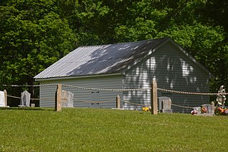
The Old Chapel Church, also known locally as the "Snow Creek Chapel", was built in 1769 as a chapel of ease for the Church of England parish in what is today Penhook, Virginia, United States.
References
- ↑ DeLorme (2005). Virginia Atlas & Gazetteer. Yarmouth, Maine: DeLorme. ISBN 0-89933-326-5
- ↑ U.S. Geological Survey Geographic Names Information System: Roanoke River
- ↑ "River Project Restores Flow and Habitat for Logperch" by Casey Fabris. Roanoke Times. February 16, 2017. Virginia Section, pages 1 and 8.
- ↑ Clement, Maud Carter. An Abbreviated History of Pittsylvania County, Virginia.
Coordinates: 36°58′17″N79°47′29″W / 36.971469°N 79.791253°W