Pinewood, Florida

Last updated

Pinewood, Florida
Miami-Dade County Florida Incorporated and Unincorporated areas Pinewood Highlighted.svg
Location in Miami-Dade County and the state of Florida
Pinewood.gif
U.S. Census Bureau map showing CDP boundaries
Coordinates: 25°52′14″N80°13′2″W / 25.87056°N 80.21722°W / 25.87056; -80.21722
Country Flag of the United States.svg  United States of America
State Flag of Florida.svg  Florida
County Flag of Miami-Dade County, Florida.png Miami-Dade
Area
[1]
  Total1.89 sq mi (4.90 km2)
  Land1.75 sq mi (4.54 km2)
  Water0.14 sq mi (0.36 km2)
Elevation
7 ft (2 m)
Population
 (2020) [2]
  Total17,246
  Density9,854.9/sq mi (3,805.0/km2)
Time zone UTC-5 (Eastern (EST))
  Summer (DST) UTC-4 (EDT)
ZIP Codes
33147, 33150, 33167, 33168 (all - Miami)
Area code(s) 305, 786, 645
FIPS code 12-57250 [3]
GNIS feature ID1867187 [4]

Pinewood is an unincorporated community and census-designated place (CDP) in Miami-Dade County, Florida, United States. It is part of the Miami metropolitan area of South Florida. The population was 17,246 at the 2020 census. [2]

Contents

Most of Pinewood was originally a neighborhood of the City of Miami, annexed into the city in 1925. [5] With the arrival of the Great Depression, Miami gave up its jurisdiction and Pinewood became an unincorporated area of Miami-Dade County. [5]

Geography

Pinewood is located 8 miles (13 km) north of downtown Miami. It is bordered to the north by the city of North Miami, to the east by Miami Shores and unincorporated neighborhoods, to the south and southwest by unincorporated West Little River, and to the northwest by unincorporated Westview. U.S. Route 441 (NW 7th Avenue) forms most of the eastern border of Pinewood.

According to the United States Census Bureau, the CDP has a total area of 1.9 square miles (4.9 km2), of which 1.8 square miles (4.7 km2) are land and 0.1 square miles (0.3 km2), or 7.30%, are water. [1]

Demographics

Historical population
CensusPop.Note
1980 16,252
1990 15,518−4.5%
2000 16,5236.5%
2010 16,5200.0%
2020 17,2464.4%
U.S. Decennial Census [6]

2010 and 2020 census

Pinewood, Florida – Racial and ethnic composition
Note: the US Census treats Hispanic/Latino as an ethnic category. This table excludes Latinos from the racial categories and assigns them to a separate category. Hispanics/Latinos may be of any race.
Race / Ethnicity (NH = Non-Hispanic)Pop 2010 [7] Pop 2020 [8] % 2010% 2020
White (NH)3683852.23%2.23%
Black or African American (NH)11,99511,39872.61%66.09%
Native American or Alaska Native (NH)27100.16%0.06%
Asian (NH)77430.47%0.25%
Pacific Islander or Native Hawaiian (NH)710.04%0.01%
Some other race (NH)50660.30%0.38%
Mixed race or Multiracial (NH)2352691.42%1.56%
Hispanic or Latino (any race)3,7615,07422.77%29.42%
Total16,52017,246100.00%100.00%

As of the 2020 United States census, there were 17,246 people, 4,968 households, and 3,565 families residing in the CDP. [9]

As of the 2010 United States census, there were 16,520 people, 5,075 households, and 3,479 families residing in the CDP. [10]

2000 Census

As of the census [3] of 2000, there were 16,523 people, 5,029 households, and 3,686 families residing in the CDP. The population density was 9,621.4 inhabitants per square mile (3,714.8/km2). There were 5,329 housing units at an average density of 3,103.1 per square mile (1,198.1/km2). The racial makeup of the CDP was 19.26% White (3.6% were Non-Hispanic White), [11] 71.05% African American, 0.25% Native American, 0.33% Asian, 0.03% Pacific Islander, 3.59% from other races, and 5.50% from two or more races. Hispanic or Latino of any race were 22.85% of the population.

As of 2000, there were 5,029 households, out of which 41.0% had children under the age of 18 living with them, 36.3% were married couples living together, 28.5% had a female householder with no husband present, and 26.7% were non-families. 21.7% of all households were made up of individuals, and 6.9% had someone living alone who was 65 years of age or older. The average household size was 3.25 and the average family size was 3.77.

In 2000, in the CDP, the population was spread out, with 32.1% under the age of 18, 11.2% from 18 to 24, 26.6% from 25 to 44, 21.2% from 45 to 64, and 8.9% who were 65 years of age or older. The median age was 30 years. For every 100 females, there were 92.6 males. For every 100 females age 18 and over, there were 88.9 males.

In 2000, the median income for a household in the CDP was $24,949, and the median income for a family was $26,548. Males had a median income of $22,439 versus $18,046 for females. The per capita income for the CDP was $10,169. About 30.2% of families and 33.5% of the population were below the poverty line, including 45.9% of those under age 18 and 21.2% of those age 65 or over.

As of 2000, speakers of English as a first language accounted for 47.40% of residents, while French Creole made up 28.93%, Spanish was at 22.09%, and French was the mother tongue of 1.56% of the population. [12]

Related Research Articles

<span class="mw-page-title-main">University, Hillsborough County, Florida</span> Census-designated place in Florida, United States

University is an unincorporated census-designated place in Hillsborough County, Florida, United States. The population was 41,163 at the 2010 census, up from 30,736 at the 2000 census. The University of South Florida is located just southeast of the community, within the Tampa city limits. The community is also known as "University West", mainly due to its location in relation to the university. The community is often notoriously referred to by locals as "Suitcase City" due to the high rate of transients.

<span class="mw-page-title-main">Brownsville, Florida</span> Census-designated place in Florida

Brownsville is an unincorporated community and census-designated place (CDP) that is part of the Miami metropolitan area of South Florida. As of the 2020 US census, the population was 16,583, up from 15,313 in 2010. After three decades of population loss, Brownsville gained population for the first time in over 40 years in the 2010 US Census.

<span class="mw-page-title-main">Country Club, Florida</span> Census-designated place in Florida

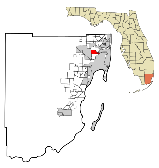
Country Club is a suburban census-designated place located in northwest Miami-Dade County, Florida, United States. It is located in the Miami metropolitan area of South Florida. The CDP is named after the Country Club of Miami, which was established in 1961 in what was then an unpopulated and undeveloped section of the county. The population was 49,967 at the 2020 census, up from 3,408 in 1990.

<span class="mw-page-title-main">Gladeview, Florida</span> Census-designated place in Florida

Gladeview is a census-designated place (CDP) in Miami-Dade County, Florida, United States. It is part of the Miami metropolitan area of South Florida. The population was 14,927 at the 2020 census, up from 11,535 in 2010.

<span class="mw-page-title-main">Glenvar Heights, Florida</span> Census-designated place in Florida

Glenvar Heights is a census-designated place (CDP) and neighborhood in Miami-Dade County, Florida, United States. It is part of the Miami metropolitan area of South Florida. The population was 20,786 at the 2020 US census, up from 16,898 in 2010 US census.

<span class="mw-page-title-main">Homestead Base, Florida</span> Census-designated place in Florida

Homestead Base is a census-designated place (CDP) in Miami-Dade County, Florida, United States. The CDP comprises the extent of Homestead Air Reserve Base plus some surrounding land. It is part of the Miami metropolitan area of South Florida. The population was 999 at the 2020 census.

<span class="mw-page-title-main">Ives Estates, Florida</span> Census-designated place in Florida

Ives Estates is a census-designated place (CDP) in Miami-Dade County, Florida. It is part of the Miami metropolitan area of South Florida. The population was 25,005 at the 2020 census, up from 19,525 in 2010.

<span class="mw-page-title-main">Kendall West, Florida</span> Census-designated place in Florida

Kendall West is a census-designated place and unincorporated community in Miami-Dade County, Florida, west of the Florida Turnpike. It is located in the Miami metropolitan area of South Florida. The population was 36,536 at the 2020 census.

<span class="mw-page-title-main">Leisure City, Florida</span> Census-designated place in Florida

Leisure City is an unincorporated community and census-designated place (CDP) in Miami-Dade County, Florida, United States, that includes the smaller, older community of Modello in its northwestern section. The CDP is most notable for the Coral Castle Museum, located in the Modello area. It is located in the Miami metropolitan area of South Florida. The population was 26,324 at the 2020 census, up from 22,655 in 2010.

<span class="mw-page-title-main">Naranja, Florida</span> Census-designated place in Florida

Naranja is an unincorporated community and census-designated place (CDP) in Miami-Dade County, Florida, United States. Many orange groves were once located in this area, so the community name came from the Spanish word for orange, naranja, though the pronunciation among the local residents is "Na-Ran-Jah". Naranja was also a stop for the Florida East Coast Railroad that once ran through this area. It is part of the Miami metropolitan area of South Florida. The population was 13,509 at the 2020 census, up from 8,303 in 2010.

<span class="mw-page-title-main">Palmetto Estates, Florida</span> Census-designated place in Florida

Palmetto Estates is an unincorporated area and census-designated place (CDP) in Miami-Dade County, Florida, United States. It is part of the Miami metropolitan area of South Florida. The population was 13,498 at the 2020 census.

<span class="mw-page-title-main">Princeton, Florida</span> Census-designated place in Florida

Princeton is a census-designated place (CDP) and unincorporated community in Miami-Dade County, Florida, United States. It is part of the Miami metropolitan area of South Florida. The population was 39,208 at the 2020 census, up from 22,038 at the 2010 census.

<span class="mw-page-title-main">Richmond West, Florida</span> Census-designated place in Florida

Richmond West is a census-designated place (CDP) in Miami-Dade County, Florida, United States. It is part of the Miami metropolitan area of South Florida. The population was 35,884 at the 2020 census, up from 31,973 at the 2010 census.

<span class="mw-page-title-main">Sunset, Florida</span> Census-designated place in Florida

Sunset is a census-designated place (CDP) in Miami-Dade County, Florida, United States. It is part of the Miami metropolitan area of South Florida. The population was 15,912 at the 2020 census. The U.S. Postal Service uses the ZIP Codes of 33173 and 33183 for Sunset.

<span class="mw-page-title-main">Three Lakes, Florida</span> Census-designated place in Florida

Three Lakes is a census-designated place (CDP) and planned community in Miami-Dade County, Florida, United States. It is part of the Miami metropolitan area of South Florida. The population was 16,540 at the 2020 census, up from 15,047 in 2010.

<span class="mw-page-title-main">West Little River, Florida</span> CDP in Miami-Dade County, Florida, US

West Little River is a census-designated place (CDP) in Miami-Dade County, Florida, United States. It is part of the Miami metropolitan area of South Florida. The population was 34,128 at the 2020 census.

<span class="mw-page-title-main">West Perrine, Florida</span> Census-designated place in Florida

West Perrine is a census-designated place (CDP) in Miami-Dade County, Florida, United States. It is part of the Miami metropolitan area of South Florida. The population was 10,602 at the 2020 census, up from 9,460 in 2010.

<span class="mw-page-title-main">Westview, Florida</span> Census-designated place in Florida

Westview is a census-designated place (CDP) in Miami-Dade County, Florida, United States. It is part of the Miami metropolitan area of South Florida. The population was 9,923 at the 2020 census.

<span class="mw-page-title-main">South Miami Heights, Florida</span> Census-designated place in Florida

South Miami Heights is a census-designated place (CDP), originally known as Eureka, in Miami-Dade County, Florida. It is part of the Miami metropolitan area of South Florida. The population was 36,770 as of the 2020 census.

<span class="mw-page-title-main">Alafaya, Florida</span> Census-designated place in Florida, United States

Alafaya is a census-designated place and unincorporated area in Orange County, Florida, United States. The population was 92,452 at the 2020 US census. It is part of the Orlando–Kissimmee–Sanford, Florida Metropolitan Statistical Area. It is most known for being near the University of Central Florida, Avalon Park and Waterford Lakes.

References

  1. 1 2 "2022 U.S. Gazetteer Files: Florida". United States Census Bureau. Retrieved January 11, 2023.
  2. 1 2 "P1. Race – Pinewood CDP, Florida: 2020 DEC Redistricting Data (PL 94-171)". U.S. Census Bureau. Retrieved January 11, 2023.
  3. 1 2 "U.S. Census website". United States Census Bureau . Retrieved January 31, 2008.
  4. "US Board on Geographic Names". United States Geological Survey. October 25, 2007. Retrieved January 31, 2008.
  5. 1 2 "Original Miami, incorporated 1896, with subsequent annexations, dis-annexations & re-annexations". Digital Public Library of America . Retrieved August 24, 2023.
  6. "Decennial Census of Population and Housing by Decades". US Census Bureau.
  7. "P2 Hispanic or Latino, and Not Hispanic or Latino by Race – 2010: DEC Redistricting Data (PL 94-171) - Pinewood CDP, Florida". United States Census Bureau . Retrieved January 19, 2022.
  8. "P2 Hispanic or Latino, and Not Hispanic or Latino by Race – 2020: DEC Redistricting Data (PL 94-171) - Pinewood CDP, Florida". United States Census Bureau . Retrieved January 19, 2022.
  9. "S1101 HOUSEHOLDS AND FAMILIES - 2020: Pinewood CDP, Florida". United States Census Bureau .
  10. "S1101 HOUSEHOLDS AND FAMILIES - 2010: Pinewood CDP, Florida". United States Census Bureau .
  11. "Demographics of Pinewood, FL". MuniNetGuide.com. Retrieved November 7, 2007.
  12. "MLA Data Center Results of Pinewood, FL". Modern Language Association . Retrieved November 7, 2007.