Plainfield, Ohio

Last updated

Plainfield, Ohio
Thomas Johnson House in Plainfield.jpg
The Thomas Johnson House on Main Street
OHMap-doton-Plainfield.png
Location of Plainfield, Ohio
Map of Coshocton County Ohio Highlighting Plainfield Village.png
Location of Plainfield in Coshocton County
Coordinates: 40°12′18″N81°43′05″W / 40.20500°N 81.71806°W / 40.20500; -81.71806
Country United States
State Ohio
County Coshocton
Township Linton
Area
[1]
  Total0.39 sq mi (1.02 km2)
  Land0.39 sq mi (1.02 km2)
  Water0.00 sq mi (0.00 km2)
Elevation
[2]
791 ft (241 m)
Population
 (2020)
  Total141
  Density359.69/sq mi (138.83/km2)
Time zone UTC-5 (Eastern (EST))
  Summer (DST) UTC-4 (EDT)
ZIP code
43836
Area code 740
FIPS code 39-63044 [3]
GNIS feature ID2399683 [2]

Plainfield is a village in Coshocton County, Ohio, United States, along Wills Creek. The population was 141 at the 2020 census.

Contents

History

Plainfield was laid out in 1816. [4] It was named from its setting upon the plains. [5] By 1833, businesses in Plainfield included one store and one tavern. [6] Plainfield was incorporated as a village in 1878. [7]

Geography

According to the United States Census Bureau, the village has a total area of 0.41 square miles (1.06 km2), all land. [8]

Demographics

Historical population
CensusPop.Note
1860 30
1880 300
1890 234−22.0%
1900 2559.0%
1910 215−15.7%
1920 172−20.0%
1930 1836.4%
1940 130−29.0%
1950 1364.6%
1960 17830.9%
1970 1832.8%
1980 22120.8%
1990 178−19.5%
2000 158−11.2%
2010 157−0.6%
2020 141−10.2%
U.S. Decennial Census [9]

2010 census

As of the census [10] of 2010, there were 157 people, 69 households, and 46 families living in the village. The population density was 382.9 inhabitants per square mile (147.8/km2). There were 76 housing units at an average density of 185.4 per square mile (71.6/km2). The racial makeup of the village was 96.8% White, 0.6% African American, and 2.5% from two or more races.

There were 69 households, of which 20.3% had children under the age of 18 living with them, 58.0% were married couples living together, 5.8% had a female householder with no husband present, 2.9% had a male householder with no wife present, and 33.3% were non-families. 29.0% of all households were made up of individuals, and 14.5% had someone living alone who was 65 years of age or older. The average household size was 2.28 and the average family size was 2.74.

The median age in the village was 50.5 years. 19.1% of residents were under the age of 18; 6.4% were between the ages of 18 and 24; 18.4% were from 25 to 44; 37.6% were from 45 to 64; and 18.5% were 65 years of age or older. The gender makeup of the village was 49.0% male and 51.0% female.

2000 census

As of the census [3] of 2000, there were 158 people, 66 households, and 45 families living in the village. The population density was 377.4 inhabitants per square mile (145.7/km2). There were 72 housing units at an average density of 172.0 per square mile (66.4/km2). The racial makeup of the village was 98.73% White, 0.63% Asian, and 0.63% from two or more races.

There were 66 households, out of which 28.8% had children under the age of 18 living with them, 57.6% were married couples living together, 4.5% had a female householder with no husband present, and 31.8% were non-families. 30.3% of all households were made up of individuals, and 9.1% had someone living alone who was 65 years of age or older. The average household size was 2.39 and the average family size was 2.93.

In the village, the population was spread out, with 21.5% under the age of 18, 7.6% from 18 to 24, 36.1% from 25 to 44, 18.4% from 45 to 64, and 16.5% who were 65 years of age or older. The median age was 39 years. For every 100 females there were 100.0 males. For every 100 females age 18 and over, there were 113.8 males.

The median income for a household in the village was $39,821, and the median income for a family was $41,806. Males had a median income of $25,625 versus $15,833 for females. The per capita income for the village was $16,441. None of the families and 2.6% of the population were living below the poverty line.

Related Research Articles

<span class="mw-page-title-main">Coshocton County, Ohio</span> County in Ohio, United States

Coshocton County is a county located in the U.S. state of Ohio. As of the 2020 census, the population was 36,612. Its county seat and largest city is Coshocton. The county lies within the Appalachian region of the state. The county was formed on January 31, 1810, from portions of Muskingum and Tuscarawas Counties and later organized in 1811. Its name comes from the Delaware Indian language and has been translated as "union of waters" or "black bear crossing". Coshocton was mentioned by David Zeisberger in his diary from the 1780s using the German spelling "Goschachgünk". The Coshocton, OH Micropolitan Statistical Area includes all of Coshocton County.

<span class="mw-page-title-main">Plainfield Village, Connecticut</span> Village in Connecticut, United States

Plainfield Village is a village and census-designated place (CDP) in the town of Plainfield, Connecticut in the United States. The population was 2,557 at the 2010 census. It is located in the southwest part of town, in the area west of I-395 and south of Route 14. The village is also the core of the Plainfield, CT urban cluster.

<span class="mw-page-title-main">Conesville, Iowa</span> City in Iowa, United States

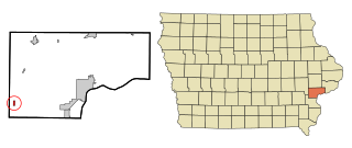
Conesville is a city in Muscatine County, Iowa, United States. The population was 352 at the 2020 census. It is part of the Muscatine Micropolitan Statistical Area.

<span class="mw-page-title-main">Aberdeen, Ohio</span> Village in Ohio, United States

Aberdeen is a village in Huntington Township, Brown County, Ohio, United States, along the Ohio River 50 miles (80 km) southeast of Cincinnati. The population was 1,515 at the 2020 census.

<span class="mw-page-title-main">Bethel, Ohio</span> Village in Ohio, United States

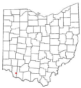
Bethel is a village in Tate Township, Clermont County, Ohio, United States. The population was 2,620 at the 2020 census. Bethel was founded in 1798 by Obed Denham as Denham Town, in what was then the Northwest Territory. Bethel is the home of the first movie theater in Ohio which was founded in 1908 by Aaron Little.

<span class="mw-page-title-main">Conesville, Ohio</span> Village in Ohio, United States

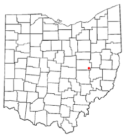
Conesville is a village in Coshocton County, Ohio, United States, along the Muskingum River. The population was 328 at the 2020 census.

<span class="mw-page-title-main">Coshocton, Ohio</span> City in Ohio, United States

Coshocton is a city in and the county seat of Coshocton County, Ohio, United States, approximately 63 miles (101 km) east-northeast of Columbus. The population was 11,050 at the 2020 census. The Walhonding River and the Tuscarawas River meet in Coshocton to form the Muskingum River.

<span class="mw-page-title-main">Nellie, Ohio</span> Village in Ohio, United States

Nellie is a village in Coshocton County, Ohio, United States, along the Walhonding River. The population was 122 at the 2020 census.

<span class="mw-page-title-main">Warsaw, Ohio</span> Village in Ohio, United States

Warsaw is a village in Coshocton County, Ohio, United States, along the Walhonding River. The population was 624 at the 2020 census.

<span class="mw-page-title-main">West Lafayette, Ohio</span> Village in Ohio, United States

West Lafayette is a village in Coshocton County, Ohio, United States. The population was 2,417 at the 2020 census.

<span class="mw-page-title-main">Brice, Ohio</span> Village in Ohio, United States

Brice is a village in Franklin County, Ohio, United States, on the southeast side of the Columbus metropolitan area. The population was 93 at the 2020 census.

<span class="mw-page-title-main">Addyston, Ohio</span> Village in Ohio, United States

Addyston is a village in Miami Township, Hamilton County, Ohio, United States. Located along the Ohio River, it is a western suburb of the neighboring city of Cincinnati. The population was 927 at the 2020 census.

<span class="mw-page-title-main">Cleves, Ohio</span> City in Ohio, United States

Cleves is a village in Miami Township, Hamilton County, Ohio, United States. Located along the Ohio River, it is a western suburb of Cincinnati. The population was 3,414 at the 2020 census.

<span class="mw-page-title-main">Evendale, Ohio</span> Village in Ohio, United States

Evendale is a village in Hamilton County, Ohio, United States, within the Cincinnati metropolitan area. The population was 2,669 at the 2020 census.

<span class="mw-page-title-main">Hanover, Ohio</span> Village in Ohio, United States

Hanover is a village in Licking County, Ohio, United States. The population was 1,270 at the 2020 census. The village lies along Ohio State Route 16.

<span class="mw-page-title-main">Newcomerstown, Ohio</span> Village in Ohio, United States

Newcomerstown is a village in Tuscarawas County, Ohio, United States, 85 miles (137 km) east-northeast of Columbus. The population was 3,702 at the 2020 census.

<span class="mw-page-title-main">Macksburg, Ohio</span> Village in Ohio, United States

Macksburg is a village in Washington County, Ohio, United States, along the West Fork of Duck Creek. The population was 120 at the 2020 census. The village is about 28 miles (45 km) south of Cambridge, Ohio.

<span class="mw-page-title-main">Gratiot, Ohio</span> Village in Ohio, United States

Gratiot is a village in Licking and Muskingum counties in the U.S. state of Ohio. The population was 215 at the 2020 census.

Plainfield is a town in Waushara County, Wisconsin, United States. The population was 533 at the 2000 census. The village of Plainfield is surrounded by the town. The ghost town of West Plainfield is located in the town.

<span class="mw-page-title-main">Plainfield, Wisconsin</span> Village in Wisconsin, United States

Plainfield is a village in Waushara County, Wisconsin, United States. The village is located almost entirely within the Town of Plainfield. A tiny portion extends into adjacent Town of Oasis. The population was 897 at the 2010 census.

References

  1. "ArcGIS REST Services Directory". United States Census Bureau. Retrieved September 20, 2022.
  2. 1 2 U.S. Geological Survey Geographic Names Information System: Plainfield, Ohio
  3. 1 2 "U.S. Census website". United States Census Bureau . Retrieved January 31, 2008.
  4. Hunt, William Ellis (1876). Historical Collections of Coshocton County, Ohio. R. Clarke & Company. pp.  4.
  5. Graham, Albert Adams (1881). History of Coshocton County, Ohio: Its Past and Present, 1740-1881. A. A. Graham. pp.  550.
  6. Kilbourn, John (1833). The Ohio Gazetteer, or, a Topographical Dictionary. Scott and Wright. pp.  375 . Retrieved December 12, 2013.
  7. Overman, William Daniel (1958). Ohio Town Names. Akron, OH: Atlantic Press. p. 112.
  8. "US Gazetteer files 2010". United States Census Bureau. Archived from the original on January 25, 2012. Retrieved January 6, 2013.
  9. "Census of Population and Housing". Census.gov. Retrieved June 4, 2015.
  10. "U.S. Census website". United States Census Bureau . Retrieved January 6, 2013.