Pleasant Garden, North Carolina

Last updated

Pleasant Garden, North Carolina
Seal of Pleasant Garden, North Carolina.jpg
Motto(s): 
"Remembering the Past, While Moving towards the Future"
Guilford County North Carolina incorporated and unincorporated areas Pleasant Garden highlighted.svg
Location in Guilford County and the state of North Carolina.
Coordinates: 35°57′34″N79°45′35″W / 35.95944°N 79.75972°W / 35.95944; -79.75972
Country United States
State North Carolina
County Guilford
Area
[1]
  Total15.16 sq mi (39.25 km2)
  Land15.04 sq mi (38.95 km2)
  Water0.12 sq mi (0.31 km2)
Elevation
[2]
807 ft (246 m)
Population
 (2020)
  Total5,000
  Density332.51/sq mi (128.39/km2)
Time zone UTC-5 (Eastern (EST))
  Summer (DST) UTC-4 (EDT)
ZIP code
27313
Area code 336
FIPS code 37-52760 [3]
GNIS feature ID2407133 [2]
Website Official Website of Pleasant Garden, North Carolina

Pleasant Garden is a town in Guilford County, North Carolina, United States.

Contents

As of the 2020 census, the town's population was 5,000. [4]

History

Incorporated in 1997 from Fentress Township, Pleasant Garden was first settled in 1786, and known as a business district by that name from at least 1876.

Geography

Pleasant Garden is situated south of Greensboro, west of Forest Oaks, and north of Climax. It is bordered both east and west by U.S. Route 421 and Old U.S. Highway 220 (Randleman Road) (Respectively), and to the north by Interstate 85.

According to the United States Census Bureau, the town has a total area of 15.4 square miles (40 km2), of which 15.3 square miles (40 km2) is land and 0.04 square miles (0.10 km2) (0.26%) is water.

Demographics

Historical population
CensusPop.Note
1980 1,991
1990 2,22811.9%
2000 4,714111.6%
2010 4,489−4.8%
2020 5,00011.4%
2022 (est.)5,020 [5] 0.4%
U.S. Decennial Census [6]

2020 census

Pleasant Garden racial composition [7]
RaceNumberPercentage
White (non-Hispanic)3,59471.88%
Black or African American (non-Hispanic)79215.84%
Native American 180.36%
Asian 280.56%
Pacific Islander 40.08%
Other/Mixed 1933.86%
Hispanic or Latino 3717.42%

As of the 2020 United States census, there were 5,000 people, 1,817 households, and 1,220 families residing in the town.

2000 census

As of the census [3] of 2000, there were 4,714 people, 1,783 households, and 1,383 families residing in the town. The population density was 307.2 inhabitants per square mile (118.6/km2). There were 1,874 housing units at an average density of 122.1 per square mile (47.1/km2). The racial makeup of the town was 85.19% White, 11.24% African American, 1.08% Native American, 0.23% Asian, 0.02% Pacific Islander, 1.04% from other races, and 1.19% from two or more races. Hispanic or Latino of any race were 1.63% of the population.

There were 1,783 households, out of which 34.1% had children under the age of 18 living with them, 65.3% were married couples living together, 8.4% had a female householder with no husband present, and 22.4% were non-families. 18.4% of all households were made up of individuals, and 7.6% had someone living alone who was 65 years of age or older. The average household size was 2.62 and the average family size was 2.97.

In the town, the population was spread out, with 25.0% under the age of 18, 5.6% from 18 to 24, 29.3% from 25 to 44, 27.9% from 45 to 64, and 12.2% who were 65 years of age or older. The median age was 39 years. For every 100 females, there were 96.0 males. For every 100 females age 18 and over, there were 93.5 males.

The median income for a household in the town was $45,833, and the median income for a family was $51,818. Males had a median income of $36,052 versus $29,778 for females. The per capita income for the town was $20,679. About 8.0% of families and 8.9% of the population were below the poverty line, including 10.5% of those under age 18 and 13.5% of those age 65 or over.

Notable people

Related Research Articles

<span class="mw-page-title-main">Sparta, Illinois</span> City in Illinois, United States

Sparta is a city in Randolph County, Illinois, United States. The population was 4,095 at the 2020 census.

<span class="mw-page-title-main">Pleasant Hill, Missouri</span> City in Missouri, United States

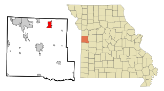
Pleasant Hill is a city in Cass and Jackson counties, Missouri, United States. The population was 8,113 at the 2010 census. It is part of the Kansas City metropolitan area.

<span class="mw-page-title-main">Green Level, North Carolina</span> Town in North Carolina, United States

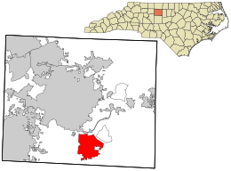
Green Level is a town in Alamance County, North Carolina, United States. It is part of the Burlington, North Carolina Metropolitan Statistical Area. As of the 2020 census, the population was 3,156.

<span class="mw-page-title-main">Sparta, North Carolina</span> Town in North Carolina, United States

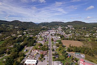
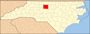
Sparta is a town in Alleghany County, North Carolina, United States. As of the 2020 census, the population of the town was 1,834. It is the county seat of Alleghany County.

<span class="mw-page-title-main">Jefferson, North Carolina</span> Town in North Carolina, United States

Jefferson is a town in and the county seat of Ashe County, North Carolina, United States. The population was 1,622 at the 2020 U.S. census.

<span class="mw-page-title-main">Shallotte, North Carolina</span> Town in North Carolina, United States

Shallotte is a town in Brunswick County, North Carolina, United States. The population was 3,675 at the 2010 census. The Shallotte River passes through the town.

<span class="mw-page-title-main">Mount Pleasant, North Carolina</span> Town in North Carolina, United States

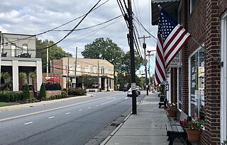
Mount Pleasant is a town located in eastern Cabarrus County, North Carolina, United States. As of the 2010 census, the town population was 1,652. The town center is located at the crossroads of Mount Pleasant Road and North Carolina Highway 73. NC Highway 49 skirts the town to the north on its way from Charlotte to Asheboro.

<span class="mw-page-title-main">Cape Carteret, North Carolina</span> Town in North Carolina, United States

Cape Carteret is a town in Carteret County, on the southern coast of North Carolina, United States. It was incorporated in 1959 and had a population of 2,224 as of the 2020 census.

<span class="mw-page-title-main">Pine Knoll Shores, North Carolina</span> Town in North Carolina, United States

Pine Knoll Shores is a coastal town in Carteret County, North Carolina, United States. The population was 1,388 at the 2020 census. One of North Carolina's state aquariums is located here.

<span class="mw-page-title-main">River Bend, North Carolina</span> Town in North Carolina, United States

River Bend is a town in Craven County, North Carolina, United States. The population was 3,119 as of the 2010 census. It is part of the New Bern, North Carolina Metropolitan Statistical Area.

<span class="mw-page-title-main">Clemmons, North Carolina</span> Village in North Carolina

Clemmons is a village in Forsyth County, North Carolina, United States and a suburb of Winston-Salem. The population was 21,177 at the 2020 census, with an estimated population of 21,517 in 2021.

<span class="mw-page-title-main">Sedalia, North Carolina</span> Town in North Carolina, United States

Sedalia is a town in Guilford County, North Carolina, United States. As of the 2020 census, the population of the town was 676.

<span class="mw-page-title-main">Stokesdale, North Carolina</span> Town in North Carolina, United States

Stokesdale is a town in Guilford County, North Carolina, United States with small parts in the counties of Rockingham, Forsyth, and Stokes. The population was 5,924 at the 2020 census. Belews Lake is located nearby, and North Carolina Highway 68 and North Carolina Highway 65 both intersect U.S. Route 158 near the town's center.

<span class="mw-page-title-main">Coats, North Carolina</span> Town in North Carolina, United States

Coats is a town in Harnett County, North Carolina, United States. The population was 2,112 at the 2010 census, and in 2018 the estimated population was 2,464. Coats is a part of the Dunn Micropolitan Area, which is a part of the greater Raleigh–Durham–Cary Combined Statistical Area (CSA) as defined by the United States Census Bureau.

<span class="mw-page-title-main">Bayboro, North Carolina</span> Town in North Carolina, United States

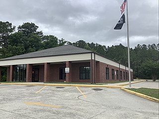
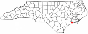
Bayboro is a town in Pamlico County, North Carolina, United States. The population was 1,161 at the 2020 U.S. census. It is the county seat of Pamlico County.

<span class="mw-page-title-main">Columbus, North Carolina</span> Town in North Carolina, United States

Columbus is a town and the county seat of Polk County, North Carolina, United States. The population was 999 at the 2010 census.

<span class="mw-page-title-main">Ramseur, North Carolina</span> Town in North Carolina, United States

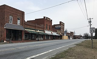
Ramseur is a town in Randolph County, North Carolina, United States. The population was 1,692 at the 2010 census.

<span class="mw-page-title-main">Sharpsburg, North Carolina</span> Town in North Carolina, United States

Sharpsburg is a town in Edgecombe, Nash, and Wilson counties, North Carolina, United States. It is part of the Rocky Mount, North Carolina Metropolitan Statistical Area. The population was 2,024 at the 2010 Census.

<span class="mw-page-title-main">Whitakers, North Carolina</span> Town in North Carolina, United States

Whitakers is a town in Edgecombe and Nash Counties in the U.S. state of North Carolina. It is divided between the two counties by railroad tracks and is the northernmost town in the two counties. It is part of the Rocky Mount, North Carolina Metropolitan Statistical Area. The population was 744 in 2010.

<span class="mw-page-title-main">Weddington, North Carolina</span> Town in North Carolina, United States

Weddington is a suburban town in Union County, North Carolina, United States. The population was 9,459 at the 2010 census. It is a suburb in the Charlotte metropolitan area. The current mayor of Weddington is Jim Bell.

References

  1. "ArcGIS REST Services Directory". United States Census Bureau. Retrieved September 20, 2022.
  2. 1 2 U.S. Geological Survey Geographic Names Information System: Pleasant Garden, North Carolina
  3. 1 2 "U.S. Census website". United States Census Bureau . Retrieved January 31, 2008.
  4. "Explore Census Data". data.census.gov. Retrieved October 27, 2023.
  5. "Annual Estimates of the Resident Population for Incorporated Places in North Carolina: April 1, 2020 to July 1, 2022". Census.gov. Retrieved April 19, 2024.
  6. "Census of Population and Housing". Census.gov. Retrieved June 4, 2015.
  7. "Explore Census Data". data.census.gov. Retrieved December 20, 2021.