Summerfield, North Carolina

Last updated

Summerfield, North Carolina
Summerfield Historic District 02.jpg
Summerfield Town Hall
Motto(s): 
"Respectful of the Past; Focused on the Future"
Guilford County North Carolina incorporated and unincorporated areas Summerfield highlighted.svg
Location in Guilford County and the state of North Carolina.
Coordinates: 36°11′51″N79°53′59″W / 36.19750°N 79.89972°W / 36.19750; -79.89972
Country United States
State North Carolina
County Guilford
Founded1769
Incorporated1996
Named for John Summerfield [1]
Government
  MayorTim Sessoms
  Mayor Pro TemLynne Williams DeVaney
  Town CouncilJeff Davis, Janelle Robinson, Reece Walker, Lynne DeVaney, John Doggett [2]
Area
[3]
  Total26.69 sq mi (69.12 km2)
  Land26.40 sq mi (68.37 km2)
  Water0.29 sq mi (0.75 km2)
Elevation
[4]
856 ft (261 m)
Population
 (2020)
  Total10,951
  Density414.87/sq mi (160.18/km2)
Time zone UTC-5 (Eastern (EST))
  Summer (DST) UTC-4 (EDT)
ZIP code
27358
Area code(s) 336, 743
FIPS code 37-65580 [5]
GNIS feature ID2406682 [4]
Website Official website

Summerfield is a town in Guilford County, North Carolina. As of the 2020 census, the population was 10,951. [6]

Contents

The town is largely regarded as a suburb of Greensboro and as development has grown, the town has slowly transformed from a rural farming area into a bedroom community. It features a town hall, along Oak Ridge Road (aka NC 150), west of Battleground Avenue (aka US 220), as well as a shopping center east of Battleground Avenue and Auburn Road, located on the eastern portion of NC 150. Interstate 73 passes just west of the town's center, connecting with NC 150, and also connecting with US 158 in the northernmost part of the town.

History

The area was settled in about 1769 by Charles Bruce and acquired the name Bruce's Crossroads. [7] In February 1781 patriot forces under General Henry Lee III and British forces under General Banastre Tarleton skirmished at the crossroads during the American Revolutionary War. [8] In 1812 a post office was established, and the community was renamed Summerfield, in homage to evangelist John Summerfield. [7]

Summerfield School Gymnasium and Community Center has a gym that was listed on the National Register of Historic Places in 2012. [9] The Summerfield Historic District was listed in 2005. [10]

Former North Carolina Governor Alexander Martin had a house that he lived in the town square of Summerfield, which is not standing today. George Washington stayed in the house during the Revolutionary War. There is currently a historical home on the square known as the Martin House, but it was lived in by a son of the Governor. Currently, the Martin House is owned by the town of Summerfield.

Geography

According to the U.S. Census Bureau, the town has a total area of 27.3 square miles (70.7 km2), of which 27.1 square miles (70.2 km2) is land and 0.2 square miles (0.4 km2) (0.62%) is water.

Demographics

Historical population
CensusPop.Note
1980 1,680
1990 2,05122.1%
2000 7,018242.2%
2010 10,23245.8%
2020 10,9517.0%
2022 (est.)11,111 [11] 1.5%
U.S. Decennial Census [12]

2020 census

As of the 2020 U.S. census, there were 10,951 people, 3,902 households, and 3,227 families residing in the town.

2010 census

At the 2010 census, [5] there were 10,232 people, 2,518 households and 2,094 families residing in the town. The population density was 258.9 per square mile (100.0/km2). There were 2,653 housing units at an average density of 97.9 per square mile (37.8/km2). The racial makeup of the town was 93.47% Caucasian, 4.03% African American, 0.44% Native American, 0.64% Asian, 0.56% from other races, and 0.85% from two or more races. Hispanic or Latino were 1.42% of the population.

There were 2,518 households, of which 41.8% had children under the age of 18 living with them, 74.4% were married couples living together, 6.0% had a female householder with no husband present, and 16.8% were non-families. 14.0% of all households were made up of individuals, and 4.8% had someone living alone who was 65 years of age or older. The average household size was 2.78 and the average family size was 3.07.

Age distribution was 28.1% under the age of 18, 5.1% from 18 to 24, 30.5% from 25 to 44, 27.9% from 45 to 64, and 8.4% who were 65 years of age or older. The median age was 39 years. For every 100 females, there were 99.1 males. For every 100 females age 18 and over, there were 97.2 males.

The median household income was $71,738, and the median family income was $79,433. Males had a median income of $51,838 versus $32,798 for females. The per capita income for the town was $33,116. About 2.5% of families and 3.8% of the population were below the poverty line, including 4.3% of those under age 18 and 6.6% of those age 65 or over.

Summerfield racial composition [13]
RaceNumberPercentage
White (non-Hispanic)8,87881.07%
Black or African American (non-Hispanic)4704.29%
Native American 190.17%
Asian 4874.45%
Pacific Islander 70.06%
Other/Mixed 4303.93%
Hispanic or Latino 6606.03%

Education

Summerfield serves as home to Summerfield Elementary School which serves as the primary school for grades kindergarten to fifth grade in the town. Summerfield Charter Academy (SCA), a charter school operated by National Heritage Academies is also located in Summerfield and educates children from kindergarten through eighth grade although it is not as open and flexible as most charter schools tend to be. [14] Students of SCA are known as the Summerfield Stampede. Most people in Summerfield attend Northern Guilford Middle School and Northern Guilford High School, while some attend Northern Elementary School, all three located east on Route 150, in proximity to Brown Summit, and having the Nighthawk as their mascot. Some residents attend Northwest Guilford Middle School followed by Northwest Guilford High School, both of which are located nearby in Greensboro. The mascot of the NW schools and Summerfield Elementary School is the Viking.

Notable people

Related Research Articles

<span class="mw-page-title-main">Forsyth County, North Carolina</span> County in North Carolina, United States

Forsyth County is located in the northwest Piedmont of the U.S. state of North Carolina. As of the 2020 census, the population was 382,590, making it the fourth-most populous county in North Carolina. Its county seat is Winston-Salem. Forsyth County is part of the Winston-Salem, NC, Metropolitan Statistical Area, which is also included in the Greensboro–Winston-Salem–High Point, NC, Combined Statistical Area. Portions of Forsyth County are in the Yadkin Valley wine region.

<span class="mw-page-title-main">Aurora, North Carolina</span> Town in North Carolina, United States

Aurora is a town in Beaufort County, North Carolina, United States. The population was 520 at the 2010 Census.

<span class="mw-page-title-main">Shallotte, North Carolina</span> Town in North Carolina, United States

Shallotte is a town in Brunswick County, North Carolina, United States. The population was 3,675 at the 2010 census. The Shallotte River passes through the town.

<span class="mw-page-title-main">Rural Hall, North Carolina</span> Town in North Carolina, United States

Rural Hall is a town in Forsyth County, North Carolina, United States. It is a part of the Piedmont Triad. The population was 3,360 at the 2020 census. The town has one public park: Covington Memorial Park.

<span class="mw-page-title-main">Walkertown, North Carolina</span> Town in North Carolina, United States

Walkertown is a town in Forsyth County, North Carolina, United States and a rural area outside of Winston-Salem. It is part of the Piedmont Triad. The population was 5,695 at the 2020 census.

<span class="mw-page-title-main">McLeansville, North Carolina</span> Census-designated place in North Carolina, United States

McLeansville is an unincorporated community and census-designated place (CDP) in Guilford County, North Carolina, United States. The population was 1,021 at the 2010 census.

<span class="mw-page-title-main">Oak Ridge, North Carolina</span> Town in North Carolina, United States

Oak Ridge is a town in northwestern Guilford County, North Carolina, United States. As of the census of 2020, the town had a population of 7,474. Oak Ridge is 15 miles (24 km) northwest of the center of Greensboro, North Carolina's third-most populous city. Oak Ridge is a part of the Piedmont Triad urban area.

<span class="mw-page-title-main">Pleasant Garden, North Carolina</span> Town in North Carolina, United States

Pleasant Garden is a town in Guilford County, North Carolina, United States.

<span class="mw-page-title-main">Sedalia, North Carolina</span> Town in North Carolina, United States

Sedalia is a town in Guilford County, North Carolina, United States. As of the 2020 census, the population of the town was 676.

<span class="mw-page-title-main">Stokesdale, North Carolina</span> Town in North Carolina, United States

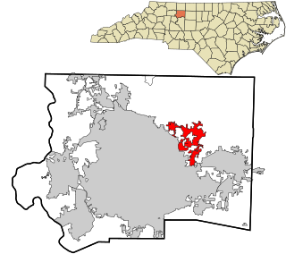
Stokesdale is a town in Guilford County, North Carolina, United States with small parts in the counties of Rockingham, Forsyth, and Stokes. The population was 5,924 at the 2020 census. Belews Lake is located nearby, and North Carolina Highway 68 and North Carolina Highway 65 both intersect U.S. Route 158 near the town's center.

<span class="mw-page-title-main">Whitsett, North Carolina</span> Town in North Carolina, United States

Whitsett is a town in Guilford County, North Carolina, United States. The population was 584 at the 2020 census.

<span class="mw-page-title-main">Marshall, North Carolina</span> Town in North Carolina, United States

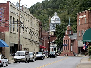
Marshall is a town in Madison County, North Carolina, United States. The population was 872 at the 2010 census. It is the county seat of Madison County.

<span class="mw-page-title-main">Williamston, North Carolina</span> Town in North Carolina, United States

Williamston is a town and the county seat of Martin County, North Carolina, United States. The population was 5,248 at the 2020 census. It is located in North Carolina's Inner Banks region. The closest major city is Greenville, approximately 28 miles (45 km) to the southwest.

<span class="mw-page-title-main">Mint Hill, North Carolina</span> Town in North Carolina, United States

Mint Hill is a suburban town in southeastern Mecklenburg and northwestern Union counties in the U.S. state of North Carolina, it is a major suburb on the outskirts of Charlotte and near the Cabarrus County line. The population was 22,722 at the 2010 census.

<span class="mw-page-title-main">Jackson, North Carolina</span> Town in North Carolina, United States

Jackson is a town in Northampton County, North Carolina, United States. The population was 513 at the 2010 census. It is the county seat of Northampton County.

<span class="mw-page-title-main">Minnesott Beach, North Carolina</span> Town in North Carolina, United States

Minnesott Beach is a town in Pamlico County, North Carolina, United States. The population was 440 at the 2010 census. It is part of the New Bern, North Carolina Metropolitan Statistical Area.

<span class="mw-page-title-main">Winterville, North Carolina</span> Town in North Carolina, United States

Winterville is a town in Pitt County, North Carolina, United States. The population was 10,591 as of the 2020 census. The town is a part of the Greenville Metropolitan Area.

<span class="mw-page-title-main">Madison, North Carolina</span> Town in North Carolina, United States

Madison is a town located in Rockingham County, North Carolina. At the 2020 census, the town had a total population of 2,132. Madison is part of the Greensboro-High Point Metropolitan Statistical Area of the Piedmont Triad metro region. It was home to the corporate headquarters of Remington Arms until 2020, when the company was made defunct by bankruptcy proceedings. It is still home to Marlin Firearms, which was an asset of Remington now owned by Sturm, Ruger & Co.

<span class="mw-page-title-main">Gibsonville, North Carolina</span> Town in North Carolina, United States

Gibsonville is a town in both Alamance and Guilford counties in the U.S. state of North Carolina. Most of Gibsonville is situated in the Greensboro-Winston-Salem-High Point Combined Statistical Area and the eastern portion is in the Burlington, North Carolina Metropolitan Statistical Area, encompassing all of Alamance County. According to the 2020 census, the population of Gibsonville was 8,971.

<span class="mw-page-title-main">Archdale, North Carolina</span> City in North Carolina, United States

Archdale is a city in Guilford and Randolph counties in the U.S. state of North Carolina. Located 15 miles southwest of Greensboro, it is part of the Greensboro-High Point Metropolitan Statistical Area of the Piedmont Triad metro region. The population of the city was 11,907 at the 2020 census.

References

  1. "North Carolina Gazetteer" . Retrieved November 24, 2023.
  2. "Council Contacts".
  3. "ArcGIS REST Services Directory". United States Census Bureau. Retrieved September 20, 2022.
  4. 1 2 U.S. Geological Survey Geographic Names Information System: Summerfield, North Carolina
  5. 1 2 "U.S. Census website". United States Census Bureau . Retrieved January 31, 2008.
  6. "Explore Census Data". data.census.gov. Retrieved August 23, 2023.
  7. 1 2 Powell 1976, p. 481.
  8. Barefoot, Daniel W. (2006). "Bruce's Cross Roads, Battle of". NCPedia. North Carolina Government & Heritage Library. Retrieved October 6, 2022.
  9. "National Register of Historic Places Listings". Weekly List of Actions Taken on Properties: 8/27/12 through 8/31/12. National Park Service. September 7, 2012.
  10. "National Register Information System". National Register of Historic Places . National Park Service. July 9, 2010.
  11. "Annual Estimates of the Resident Population for Incorporated Places in North Carolina: April 1, 2020 to July 1, 2022". Census.gov. Retrieved April 19, 2024.
  12. "Census of Population and Housing". Census.gov. Retrieved June 4, 2015.
  13. "Explore Census Data". data.census.gov. Retrieved December 20, 2021.
  14. "Home | Summerfield NC".

Works cited