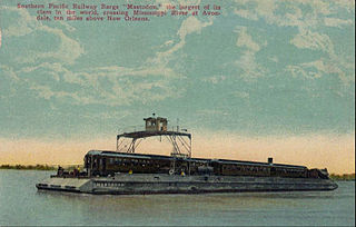
Avondale is a census-designated place (CDP) in Jefferson Parish, Louisiana, United States, on the west bank of the Mississippi River. The population was 4,582 in 2020. It is part of the New Orleans–Metairie–Kenner metropolitan statistical area.

Barataria is a census-designated place (CDP) in Jefferson Parish, Louisiana, United States. The population was 1,057 in 2020. It is part of the New Orleans–Metairie–Kenner metropolitan statistical area.
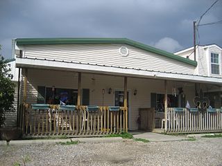
Lafitte is an unincorporated community and census-designated place (CDP) in Jefferson Parish, Louisiana, United States. The population was 972 at the 2010 census, and 816 in 2019. In 2020, its population increased to 1,014 people. It is part of the New Orleans–Metairie–Kenner metropolitan statistical area. Lafitte is located at the southern end of Louisiana Highway 45 along Bayou Barataria, and fishing is a major part of the local economy and culture.
Woodmere is an unincorporated community and census-designated place (CDP) in Jefferson Parish, Louisiana, United States. The population was 12,080 at the 2010 census, and 11,238 at the 2020 census. It is part of the New Orleans–Metairie–Kenner metropolitan statistical area.
Chackbay is a census-designated place (CDP) in northern Lafourche Parish, Louisiana, United States. The population was 5,177 at the 2010 census, up from 4,018 at the 2000 census. It is part of the Houma–Bayou Cane–Thibodaux Metropolitan Statistical Area.
Natchez is a village in Natchitoches Parish, Louisiana, United States. The population was 597 at the 2010 census. It is part of the Natchitoches Micropolitan Statistical Area. The village and parish are part of the Cane River National Heritage Area.
Violet is a census-designated place (CDP) in St. Bernard Parish, Louisiana, United States. The population was 5,758 at the 2020 census. Violet is located on the east bank of the Mississippi River, approximately 7.5 miles (12.1 km) southeast of New Orleans and is part of the New Orleans–Metairie–Kenner metropolitan statistical area.
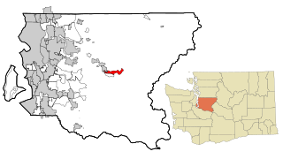
Riverpoint is an unincorporated community and census-designated place (CDP) in east King County, Washington, United States. As of the 2020 census, it had a population of 774. At the 2010 census, the area was listed as the Tanner CDP and had a population of 1,018 over a larger area.

Broussard is a city in Lafayette and St. Martin parishes in the U.S. state of Louisiana. The population was 8,197 at the 2010 U.S. census, and 13,417 at the 2020 United States census. Broussard is part of the Lafayette metropolitan statistical area.

Milton is an unincorporated community and census-designated place in Lafayette Parish, Louisiana, United States. At the 2010 U.S. census it had a population of 3,030; at the 2019 American Community Survey, it had an estimated population of 2,299. Milton is part of the Lafayette metropolitan statistical area.
Ossun is an unincorporated community and census-designated place in Lafayette Parish, Louisiana, United States. As of the 2010 census, the population was 2,144. The community is named after the area of Ossun, France, near Lourdes.

Hudson Lake is an unincorporated community and census-designated place (CDP) in Hudson Township, LaPorte County, Indiana, United States. The town sits on the dividing line between Central and Eastern time zones. It is the site of the Hudson Lake station stop of the South Shore Line. As of the 2010 census, the population of the CDP was 1,297.
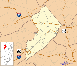
Brookfield is an unincorporated community and census-designated place (CDP) located within White Township, in Warren County, New Jersey, United States. As of the 2010 United States Census, the CDP's population was 675.
Upper Stewartsville is an unincorporated community and census-designated place (CDP) located within Greenwich Township in Warren County, New Jersey, United States, that was defined as part of the 2010 United States Census. As of the 2010 Census, the CDP's population was 212.
Hester is an unincorporated community and census-designated place in St. James Parish, Louisiana, United States. Its population was 498 as of the 2010 census. The community is located along Louisiana Highway 44 on the east bank of the Mississippi River.
Lakeshore is an unincorporated community and census-designated place in Ouachita Parish, Louisiana, United States. Its population was 1,930 as of the 2010 census. The community is located on the south bank of Bayou Desiard, east of Monroe.

Horseshoe Bend is a census-designated place in Parker County, Texas, United States. This was a new CDP for the 2010 census with a population of 789.
Bawcomville is an unincorporated community and census-designated place in Ouachita Parish, Louisiana, United States. Its population was 3,588 as of the 2010 census.
Brownsville is an unincorporated community and census-designated place in Ouachita Parish, Louisiana, United States. Its population was 4,317 as of the 2010 census.
Bayou Blue is an unincorporated community and census-designated place in Lafourche and Terrebonne parishes, Louisiana, United States. Its population was 12,352 as of the 2010 census.


