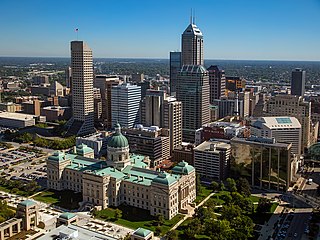
Indianapolis, colloquially known as Indy, is the capital and most populous city of the U.S. state of Indiana and the seat of Marion County. According to the 2020 United States census, the balance population was 887,642. It is the 16th-most populous city in the U.S., the third-most populous city in the Midwest after Chicago and Columbus, Ohio, and the fourth-most populous state capital after Phoenix, Arizona, Austin, Texas, and Columbus. The Indianapolis metropolitan area is the 33rd-most populous metropolitan statistical area in the U.S., with 2,111,040 residents. Its combined statistical area ranks 28th, with a population of 2,431,361. Indianapolis covers 368 square miles (950 km2), making it the 18th largest city by land area in the U.S.

The Walloomsac River from the Native American name, Wal-loom-sac is a 16.8-mile-long (27.0 km) tributary of the Hoosic River in the northeastern United States. It rises in southwestern Vermont, in the Green Mountains east of the town of Bennington in Woodford Hollow at the confluence of Bolles Brook and City Stream where it is labeled Walloomsac Brook on maps but is locally known as "The Roaring Branch". The river then flows west toward Bennington and passes the downtown area to the north. For many years this section was intermittent due to the water having been diverted to power mills in town. This divergence gave the name Walloomsac to a portion of the river flowing through town on the present course of South Stream. The combined Walloomsac / South Stream joins the Roaring Branch northwest of town. From here the river flows westward as the Walloomsac River and joins the Hoosic River below Hoosick Falls, New York.

The Monon Railroad, also known as the Chicago, Indianapolis, and Louisville Railway from 1897 to 1971, was an American railroad that operated almost entirely within the state of Indiana. The Monon was merged into the Louisville and Nashville Railroad in 1971, and much of the former Monon right of way is owned today by CSX Transportation. In 1970, it operated 540 miles (870 km) of road on 792 miles (1,275 km) of track; that year it reported 1320 million ton-miles of revenue freight and zero passenger-miles.
White River State Park is an urban park in downtown Indianapolis, Indiana. Situated along the eastern and western banks of its namesake White River, the park covers 267 acres (108 ha). The park is home to numerous attractions, including the Eiteljorg Museum of American Indians and Western Art, Indiana State Museum, Indianapolis Zoo, NCAA Hall of Champions, Victory Field, TCU Amphitheater, and the White River Gardens.

The Monon Trail is a rail trail located entirely within the state of Indiana. The Monon Railroad was a popular railroad line connecting the cities of Chicago and Indianapolis, with stops at major settlements along its route. After the decline of railroad travel and the sale of the company in 1987, the portion of the line between Indianapolis and Delphi, Indiana, was abandoned.

Garfield Park is a 128-acre (52 ha) urban park in Indianapolis, Indiana, United States. Established in the late 19th century, it is the oldest city park in Indianapolis and is on the National Register of Historic Places. The park is located at the confluence of Pleasant Run and Bean Creeks on the near Southside of Indianapolis. The 10,000-square-foot (930 m2) Conservatory and Sunken Gardens are located in the eastern portion of the park. The noted landscape architect George Edward Kessler designed the Sunken Gardens along with many of the other features of the park as part of his Park and Boulevard Plan for the city.

Fort Harrison, sometimes called Fort Ben, is an Indiana state park located in Lawrence, Indiana, United States, and occupies part of the former site of Fort Benjamin Harrison. The park features a former Citizen's Military Training Camp, Civilian Conservation Corps camp, and World War II prisoner of war camp. There are also picnicking and walking/jogging trails including a connection to the Fall Creek Greenway. The park receives nearly 900,000 visitors annually.
Luten Bridge Company and variations such as Luten Engineering Company was the name of a number of different bridge building companies in the United States during the early- to mid-20th century. Each had rights to build concrete Luten arch bridges, according to the patented designs of Daniel B. Luten, of Indianapolis.
Indianapolis has seven designated neighborhoods as Cultural Districts, first established in 1999: Broad Ripple Village; Mass Ave; Fountain Square; Wholesale District; Canal and White River State Park; Indiana Avenue; and Market East. The purpose of these designations was to capitalize on cultural institutions within historically significant neighborhoods unique to the city's heritage for economic development and revitalization.
Downtown Indianapolis is a neighborhood area and the central business district of Indianapolis, Indiana, United States. Downtown is bordered by Interstate 65, Interstate 70, and the White River, and is situated near the geographic center of Marion County. Downtown has grown from the original 1821 town plat—often referred to as the Mile Square—to encompass a broader geographic area of central Indianapolis, containing several smaller historic neighborhoods.

The history of Indianapolis spans three centuries. Founded in 1820, the area where the city now stands was originally home to the Lenape. In 1821, a small settlement on the west fork of the White River at the mouth of Fall Creek became the county seat of Marion County, and the state capital of Indiana, effective January 1, 1825. Initially the availability of federal lands for purchase in central Indiana made it attractive to the new settlement; the first European Americans to permanently settle in the area arrived around 1819 or early 1820. In its early years, most of the new arrivals to Indianapolis were Europeans and Americans with European ancestry, but later the city attracted other ethnic groups. The city's growth was encouraged by its geographic location, 2 miles (3.2 km) northwest of the state's geographic center. In addition to its designation as a seat of government, Indianapolis's flat, fertile soil, and central location within Indiana and the Midwest, helped it become an early agricultural center. Its proximity to the White River, which provided power for the town's early mills in the 1820s and 1830s, and the arrival of the railroads, beginning in 1847, established Indianapolis as a manufacturing hub and a transportation center for freight and passenger service. An expanding network of roads, beginning with the early National Road and the Michigan Road, among other routes, connected Indianapolis to other major cities.

The Indiana Central Canal was a canal intended to connect the Wabash and Erie Canal to the Ohio River. It was funded by the Mammoth Internal Improvement Act, Indiana's attempt to take part in the canal-building craze started by the Erie Canal. $3.5 million was allocated for the project, the largest piece of the entire $10 million Act. However, due to the Panic of 1837, Indiana suffered financial difficulties and had to turn the canal over to the state's creditors, and building of the canal was stopped in 1839. The canal was supposed to extend 296 miles (476 km), from Peru, Indiana, to Evansville, Indiana, where it would reach the Ohio River. It was originally divided into two sections, North and South. Later, a third section was designated, called the Indianapolis section. Only eight miles (13 km) were completed, with an additional 80 miles (130 km) between Anderson, Indiana, and Martinsville, Indiana, having been partially built.

The "Battle" of Pogue's Run took place in Indianapolis, Indiana, on May 20, 1863, during the American Civil War. It was believed that many of the delegates to the Indiana Democrats state convention were carrying firearms in the hope of inciting a rebellion. Union soldiers entered the hall in which the convention took place and found personal weapons on many of the delegates. Afterwards, Union soldiers stopped trains carrying delegates to their home areas, causing many of the delegates to throw weapons into Pogue's Run, thereby giving the event its name.
During the American Civil War, Indianapolis, the state capital of Indiana, was a major base of supplies for the Union. Governor Oliver P. Morton, a major supporter of President Abraham Lincoln, quickly made Indianapolis a gathering place to organize and train troops for the Union army. The city became a major railroad hub for troop transport to Confederate lands, and therefore had military importance. Twenty-four military camps were established in the vicinity of Indianapolis. Camp Morton, the initial mustering ground to organize and train the state's Union volunteers in 1861, was designated as a major prisoner-of-war camp for captured Confederate soldiers in 1862. In addition to military camps, a state-owned arsenal was established in the city in 1861, and a federal arsenal in 1862. A Soldiers' Home and a Ladies' Home were established in Indianapolis to house and feed Union soldiers and their families as they passed through the city. Indianapolis residents also supported the Union cause by providing soldiers with food, clothing, equipment, and supplies, despite rising prices and wartime hardships, such as food and clothing shortages. Local doctors aided the sick, some area women provided nursing care, and Indianapolis City Hospital tended to wounded soldiers. Indianapolis sent an estimated 4,000 men into military service; an estimated 700 died during the war. Indianapolis's Crown Hill National Cemetery was established as one of two national military cemeteries established in Indiana in 1866.
Transportation in Indianapolis consists of a complex network that includes a local public bus system, several private intercity bus providers, Amtrak passenger rail service, four freight rail lines, an Interstate Highway System, an airport, a heliport, bikeshare system, 115 miles (185 km) of bike lanes, and 116 miles (187 km) of trails and greenways. The city has also become known for its prevalence of electric scooters.
Fall Creek is a navigable in law waterway in the U.S. state of Indiana, and a tributary of the White River. It is 57.5 miles (92.5 km) long and has a watershed drainage area of 318 square miles (820 km2) in central Indiana before flowing into the White River in Indianapolis. As it flows southwest, Fall Creek is the namesake of three townships in Indiana, in Henry County, Madison County, and then Hamilton County.
The Pleasant Run Greenway, also known as the Pleasant Run Trail, is a shared-use path in Indianapolis, Indiana. It runs for 6.9 miles (11.1 km) from Ellenberger Park, through Christian Park, to Garfield Park. It follows the general course of Pleasant Run Creek as it flows to the south and west. Most of the greenway is located within the parkway on one side or the other of the creek; the parkway itself is part of the historic Indianapolis Park and Boulevard System. In several places, the greenway is routed on sidewalks of city streets due to existing structures and facilities that make the parkway itself discontinuous.

The Indianapolis Park and Boulevard System is a group of parks, parkways, and boulevards in Indianapolis, Indiana, that was designed by landscape architect George Edward Kessler in the early part of the twentieth century. Also known as the Kessler System, the district includes 3,474 acres (1,406 ha) and has shaped the city through the present day. This historic district was added to the National Register of Historic Places in 2003.

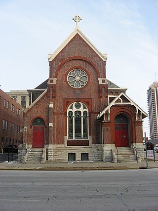
Roberts Park Methodist Episcopal Church, whose present-day name is Roberts Park United Methodist Church, was dedicated on August 27, 1876, making it one of the oldest church remaining in downtown Indianapolis. Diedrich A. Bohlen, a German-born architect who immigrated to Indianapolis in the 1850s, designed this early example of Romanesque Revival architecture. The church is considered one of Bohlen's major works. Constructed of Indiana limestone at Delaware and Vermont Streets, it has a rectangular plan and includes a bell tower on the southwest corner. The church is known for its interior woodwork, especially a pair of black-walnut staircases leading to galleries (balconies) surrounding the interior of three sides of its large sanctuary. The church was added to the National Register of Historic Places on August 19, 1982. It is home to one of several Homeless Jesus statues around the world, this one located behind the church on Alabama Street.
Mount Pisgah Lutheran Church, also known in its early years as the First Lutheran Church and First English Lutheran Church and more recently as The Sanctuary on Penn, is located at 701 North Pennsylvania Street in downtown Indianapolis, Indiana. The historic church was built by the city's first Lutheran congregation, which organized in 1837, and was its third house of worship. The former church, whose present-day name is The Sanctuary on Penn, is operated as a for-profit event venue.