The Monongahela River, sometimes referred to locally as the Mon, is a 130-mile-long (210 km) river on the Allegheny Plateau in north-central West Virginia and Southwestern Pennsylvania. The river flows from the confluence of its west and east forks in north-central West Virginia northeasterly into southwestern Pennsylvania, then northerly to Pittsburgh and its confluence with the Allegheny River to form the Ohio River. The river includes a series of locks and dams that makes it navigable.

Allegheny Islands State Park is a 43-acre (17 ha) Pennsylvania state park in Harmar Township, Allegheny County, Pennsylvania in the United States. The undeveloped park is composed of three alluvial islands located in the middle of the Allegheny River northeast of Pittsburgh. The islands are just north of the boroughs of Oakmont and Plum, and southwest of Cheswick. Bridges for the Pennsylvania Turnpike and the Bessemer and Lake Erie Railroad Branch of the Canadian National Railway cross the Allegheny River at the middle island.

Morgantown Lock and Dam is a navigational lock and a gated dam on the Monongahela River at Morgantown, West Virginia. It is part of a series of dams that canalizes the Monongahela to a depth of at least 9 feet (2.7 m) for its entire length from Fairmont, West Virginia to Pittsburgh, Pennsylvania. It is maintained by the U.S. Army Corps of Engineers' Pittsburgh District.
Hildebrand Lock and Dam is a navigational lock and gated dam on the Monongahela River at Hilderbrand, West Virginia. It is part of a series of dams that canalizes the Monongahela to a depth of at least 9 feet (2.7 m) for its entire length from Fairmont, West Virginia to Pittsburgh, Pennsylvania. It is maintained by the U.S. Army Corps of Engineers, Pittsburgh District.

Opekiska Lock and Dam is a navigational lock and gated dam on the Monongahela River at Lowsville, West Virginia. It is part of a series of dams that canalizes the Monongahela to a depth of at least 9 feet (2.7 m) for its entire length from Fairmont, West Virginia to Pittsburgh, Pennsylvania. It is maintained by the U.S. Army Corps of Engineers' Pittsburgh District.

The Cannelton Locks and Dam is a tainter-gated dam with two locks on the Ohio River, on the border between the U.S. states of Indiana and Kentucky. The dam is 2 miles (3.2 km) southeast of Cannelton, Indiana. Construction of the locks began in July 1963. The locks began operation in December 1966 and were completed April 1967. Construction on the dam started in August 1965 and the dam was completed in 1974. The structure was designed, built, and is operated by the United States Army Corps of Engineers Louisville District.

The Allegheny River Lock and Dam No. 2 in Pittsburgh, Pennsylvania is a lock and fixed-crest dam from 1932. It crosses the Allegheny River between the Pittsburgh neighborhood of Highland Park and the suburb of Aspinwall. The lock and dam were built by the U.S. Army Corps of Engineers as a part of an extensive system of locks and dams to improve navigation along the Allegheny River. It is the most-used lock operated by the United States Army Corps of Engineers.

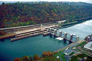
Maxwell Lock and Dam is a navigational lock and gated dam on the Monongahela River between Centerville in Washington County, and Luzerne Township in Fayette County in Pennsylvania. It is part of a series of dams that canalizes the Monongahela to a depth of at least 9 feet (2.7 m) for its entire length from Fairmont, West Virginia to Pittsburgh, Pennsylvania. It is maintained by the U.S. Army Corps of Engineers, Pittsburgh District.

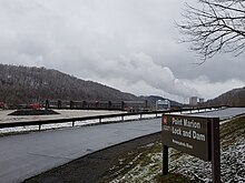
Grays Landing Lock and Dam, previously known as Lock and Dam Number 7, is one of nine navigational structures on the Monongahela River between Pittsburgh, Pennsylvania and Fairmont, West Virginia. Maintained and built by the U.S. Army Corps of Engineers, the gated dam forms an upstream pool that is 11.2 miles (18.0 km) long, stretching to the base of the Point Marion Lock and Dam. It is located at river mile 82.
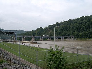
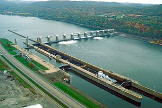
Braddock Locks & Dam is one of nine navigational structures on the Monongahela River between Pittsburgh, Pennsylvania and Fairmont, West Virginia. Built and maintained by the U.S. Army Corps of Engineers, the gated dam and the lock form an upstream pool that is for 12.6 miles (20.3 km), stretching to Elizabeth, Pennsylvania.
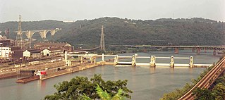
Charleroi Locks & Dam, officially known as Locks & Dam 4 by the US Army Corps of Engineers, is one of nine navigational structures on the Monongahela River between Pittsburgh, Pennsylvania and Fairmont, West Virginia. Maintained and built by the U.S. Army Corps of Engineers, the gated dam forms an upstream pool that is for 19.7 miles to the Maxwell Lock & Dam.

Dashields Lock and Dam is a fixed-crest dam on the Ohio River. It is located less than 15 miles down stream of Pittsburgh. There are two locks, one for commercial barge traffic that's 600 feet long by 110 feet wide, and the recreational auxiliary lock is 360 feet long by 56 feet wide. Dashields locks averages about 450 commercial lock throughs every month and 200-300 lock throughs a month on the recreational auxiliary lock.
New Cumberland Lock and Dam is the fourth lock and dam on the Ohio River, located 54 miles downstream of Pittsburgh. There are two locks, one for commercial barge traffic that's 1,200 feet long by 110 feet wide, and the recreational auxiliary lock is 600 feet long by 110 feet wide. New Cumberland locks averages about 320 commercial lock throughs every month and 120 lock throughs a month on the recreational auxiliary lock.

Pike Island Lock and Dam is the fifth lock and dam on the Ohio River, located in Yorkville, Ohio 84 miles downstream of Pittsburgh. There are two locks, one for commercial barge traffic that's 1,200 feet long by 110 feet wide, and the auxiliary lock is 600 feet long by 110 feet wide.
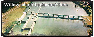
Willow Island Lock and Dam is the 7th Lock and dam on the Ohio River, located 162 miles downstream of Pittsburgh. There are two locks, one for commercial barge traffic that's 1,200 feet long by 110 feet wide, and the auxiliary lock is 600 feet long by 110 feet wide.

The Robert C. Byrd Lock and Dam, formerly the Gallipolis Lock and Dam, is the 10th lock and dam on the Ohio River, located 280 miles downstream from Pittsburgh. There are 4 locks: one for commercial barge traffic, 1,200 feet long by 110 feet wide; the auxiliary lock is 600 feet long by 110 feet wide; and there are 2 smaller parallel locks.
Greenup Lock and Dam is the 11th Lock and dam on the Ohio River, located 341 miles downstream of Pittsburgh. There are 2 locks, one for commercial barge traffic that's 1,200 feet long by 110 feet wide, and the auxiliary lock is 600 feet long by 110 feet wide.
Newburgh Lock and Dam is the 16th lock and dam on the Ohio River, located 776 miles (1,249 km) down stream of Pittsburgh.There are two locks. The main lock for commercial barge traffic that is 1,200 feet (370 m) long by 110 feet (34 m) wide, and the auxiliary lock is 600 feet (180 m) by 110 feet (34 m) wide.

Lock and Dam 52 was the 19th lock and dam on the Ohio River. It was 939 miles (1,511 km) downstream of Pittsburgh and 23 miles (37 km) upstream from the confluence of the Mississippi River with the Ohio.