Polihale State Park

Last updated

Polihale State Park
Polihale2010a.png
Polihale Beach facing north
Location Map Kauai.png
Red pog.svg
USA Hawaii location map.svg
Red pog.svg
Nearest city Kekaha
Coordinates 22°5′33″N159°45′00″W / 22.09250°N 159.75000°W / 22.09250; -159.75000
Website hawaiistateparks.org/parks/kauai/polihale-state-park/
Polihale State Park at Sunset Polihale State Park at Sunset.jpeg
Polihale State Park at Sunset

Polihale State Park is a remote wild beach on the western side of the Hawaiian island of Kauai. It is the most western publicly accessible area in Hawaii, although the privately owned island of Niihau is farther west. The park is miles away from the town of Kekaha, and it can only be reached via a poorly marked, dirt sugarcane road, making a four-wheel drive vehicle preferable. The beach is several miles long, yet only the area known as "Queen's Pond" offers safe swimming.

Contents

Location

The park is located at the western end of Kauai and has many miles of shoreline that averages about 300 feet from the barrier dunes to the surf line. Sand dunes along the beach can reach heights nearing 100 feet. Driving on the beach is no longer permitted.< https://dlnr.hawaii.gov/dsp/parks/kauai/polihale-state-park/> The only road to the park is dirt, with many ruts and potholes, and is difficult to access by non-4WD vehicles. The park is located to the north of the Pacific Missile Range Facility and Barking Sands Beach. The beach is flanked to the north by the Na Pali Coast mountain ridges. On the east side park is adjacent to the field used for agriculture, that is in turn adjacent to the mountain ridge. Mountains are so close that at night park visitors can hear goats bleating on this ridge. Road access is west from the town of Kekaha. A good local map will be needed.

Facilities

The park has running cold water, flush toilets, simple semi-private showers and a few pavilions. Visitors to the park should bring additional water, food, an umbrella or other shade apparatus and all supplies they feel they need. Nothing is available for purchase anywhere in the park. There is no medical facility or lifeguard available. Most of the year, especially during the Hawaiian Summer (March to October) the sun is extremely intense and there is no place to find shade.

Activities

Except for the usual water-related activities the park is officially open to campers. Swimming is safe only at the Queens Pond, located toward the southern end of the park. This is a wild beach. The shore is unprotected from the open ocean. The usual surfing, snorkeling, etc. are not safe activities along this beach. The beach drops off rapidly to deep water and rip currents along the shore are very strong, especially in the winter months.

History and mythology

This beach is said to have a strong basis in Hawaiian mythology.

Unofficially, Polihale has been incorrectly translated in many instances as the "House of the Po", where Po is the Hawaiian afterworld. By this account, spirits are said to travel to the coastal plain adjacent to the beach, and stay in the temple, known as the heiau. From there, they would climb the cliffs to the north, jump off into the sea to get to the mythical Po. The story further indicates that this belief was so strong that all the homes built in the vicinity of Polihale would have had no east facing doors, so that no traveling spirit could become trapped within.

The foregoing story, however, offers an erroneous translation of the place name. The name "Polihale" literally translates as "House Bosom". [1] The root Po refers to the original night/darkness from which creation is manifested. Po in this case is the "source"; poli, is literally "bosom" or "breast", revealing the word's root in the concept of "source of life". "Polihale" should not be literally translated as "bosom house", but "house bosom".

A sea lettuce called pahapaha grows in the waters near Polihale. A wreath made from pahapaha can fade and dry out, but when soaked in water, it will revive to its original freshness. Only the pahapaha from Polihale does this. According to mythology, Na-maka-o-Kaha'i, sister of Pele and Goddess of the Ocean, blessed Polihale's pahapaha with this special quality. Visitors once took home wreaths made from pahapaha from Polihale to prove they had indeed been there.

Road to Polihale

The ridge enclosing 'Ohai'ula Valley as seen from the road to Polihale Ohaiula Valley.jpg
The ridge enclosing ‘Ohai‘ula Valley as seen from the road to Polihale

In December 2008 flooding damaged facilities and closed the access road. With the park site closed and fearing the economic impact, numerous local residents and businesses volunteered to repair the road on their own rather than wait for the government to take action. The cost had been estimated at $4 million, an amount that the Department of Land and Natural Resources did not have budgeted, with repair time estimated at one to two years. On March 23, 2009, local volunteer residents and private businesses began repairing the road on their own and completed the job eight days later. [2]

As of March 25, 2011 the road to the park prefers a 4-wheel drive vehicle but a car is passable to the parking area. If it rains the road will be impassible to non-4wd.

See also

Related Research Articles

<span class="mw-page-title-main">Channels of the Hawaiian Islands</span> Names of the channels of water between the Hawaiian Islands

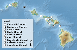
In an archipelago like the Hawaiian Islands the water between islands is typically called a channel or passage. Described here are the channels between the islands of Hawaiʻi, arranged from northwest to southeast.

<span class="mw-page-title-main">Beach</span> Area of loose particles at the edge of the sea or other body of water

A beach is a landform alongside a body of water which consists of loose particles. The particles composing a beach are typically made from rock, such as sand, gravel, shingle, pebbles, etc., or biological sources, such as mollusc shells or coralline algae. Sediments settle in different densities and structures, depending on the local wave action and weather, creating different textures, colors and gradients or layers of material.

<span class="mw-page-title-main">Kauai</span> Northernmost populated island of the Hawaiian archipelago

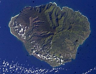
Kauaʻi, anglicized as Kauai, is geologically the second-oldest of the main Hawaiian Islands. With an area of 562.3 square miles, it is the fourth-largest of the islands and the 21st-largest island in the United States. Nicknamed the Garden Isle, Kauaʻi lies 73 miles across the Kauaʻi Channel, northwest of Oʻahu. It is the site of Waimea Canyon State Park and the Na Pali Coast State Park.

<span class="mw-page-title-main">Deepwater National Park</span> Protected area in Queensland, Australia

Deepwater is a coastal national park in Queensland, Australia, 375 km north of Brisbane. It protects an area of sand dunes and coastal heaths in the Deepwater Creek catchment. The area is one of the few remaining pristine freshwater catchments on Queensland's east coast. Deepwater National Park was established in 1988 and covers 4,090 ha.

<span class="mw-page-title-main">Waimea, Kauai County, Hawaii</span> Census-designated place in Hawaii, United States

Waimea is a census-designated place (CDP) in Kauaʻi County, Hawaiʻi, United States. The population was 2,057 at the 2020 census. The first Europeans to reach Hawaii landed in Waimea in 1778.

<span class="mw-page-title-main">Pacific Missile Range Facility</span> United States naval facility and airport in Hawaii

The Pacific Missile Range Facility, Barking Sands is a U.S. naval facility and airport located five nautical miles (9 km) northwest of the central business district of Kekaha, in Kauai County, Hawaii, United States.

<span class="mw-page-title-main">Nā Pali Coast State Park</span> State park in Hawaii, United States

Nā Pali Coast State Park is a 6,175-acre (2,499 ha) state park in the U.S. state of Hawaii, located in the center of the rugged 16-mile (26 km) northwest side of Kauaʻi, the second-oldest inhabited Hawaiian island. The Nā Pali coast itself extends southwest from Keʻe Beach all the way to Polihale State Park. The nā pali along the shoreline rise as much as 4,000 feet (1,200 m) above the Pacific Ocean. The state park was formed to protect the Kalalau Valley.

<span class="mw-page-title-main">Kaloko-Honokōhau National Historical Park</span> Historic Place in Hawaii County, Hawaii

Kaloko-Honokōhau National Historical Park is a United States National Historical Park located in the Kona District on the Big island of Hawaiʻi in the U.S. state of Hawaiʻi. It includes the National Historic Landmarked archaeological site known as the Honokōhau Settlement. The park was established on November 10, 1978, for the preservation, protection and interpretation of traditional native Hawaiian activities and culture.

<span class="mw-page-title-main">Hapuna Beach State Recreation Area</span>

Hāpuna Beach State Recreation Area is a large park and sandy beach on the Big Island of Hawaii. The Hapuna Beach Prince Hotel is also located adjacent to the beach. Hāpuna is popular with residents and visitors.

<span class="mw-page-title-main">Guadalupe-Nipomo Dunes</span> Dune system in California

Guadalupe-Nipomo Dunes is the largest remaining dune system south of San Francisco and the second largest in the U.S. state of California. It encompasses an 18-mile (29 km) stretch of coastline on the Central Coast of California and extends from southern San Luis Obispo County to northern Santa Barbara County.

<span class="mw-page-title-main">H. P. Faye</span> Hawaiian sugar plantation owner

Hans Peter (H.P.) Faye was a Norwegian-born businessman who developed sugarcane plantations on west Kauai.

<span class="mw-page-title-main">Haʻena State Park</span> Shoreline park in Kauai County, Hawaii, US

Hāʻena State Park is a state park on the north shore of the Hawaiian island of Kauaʻi. It is often called the "end of the road" and marks the endpoint of the Kuhio Highway. The park provides access to beaches, trails, and several ancient Hawaiian sites, including sea caves estimated to be more than 4,000 years old. Archaeological sites associated with the hula, including a heiau (shrine) dedicated to Laka, are above the park's beaches.

<span class="mw-page-title-main">Presque Isle State Park</span> Pennsylvania state park on Lake Erie

Presque Isle State Park is a 3,112-acre (1,259 ha) Pennsylvania State Park on an arching, sandy peninsula that juts into Lake Erie, 4 miles (6 km) west of the city of Erie, in Millcreek Township, Erie County, Pennsylvania, in the United States. The peninsula sweeps northeastward, surrounding Presque Isle Bay along the park's southern coast. It has 13 miles (21 km) of roads, 21 miles (34 km) of recreational trails, 13 beaches for swimming, and a marina. Popular activities at the park include swimming, boating, hiking, biking, and birdwatching.

<span class="mw-page-title-main">Wailua River State Park</span> State park on the island of Kauai, in Hawaii, United States

Wailua River State Park and the Wailua Complex of Heiaus, which it includes, are located on the eastern side of the Hawaiian island of Kauai. The park consists primarily of the Wailua River valley, which is the only navigable river in Hawaii. Visitors to this park can kayak, take riverboat cruises and explore the rainforest. Even motorboats and water skiing are permissible on the river.

<span class="mw-page-title-main">Kekaha Kai State Park</span> State park in Hawaii, United States

Kekaha Kai State Park, formerly known as Kona Coast State Park, is a beach park located along the north Kona coast on the island of Hawaiʻi. The main beach areas are Maniniʻowali Bay, Makalawena beach at Puʻu Aliʻi Bay, and Mahaiʻula Bay. The park's name originates from the Hawaiian language words ke kaha kai which translate to "the shore line" in English.

<span class="mw-page-title-main">Kawaikini</span> Extinct shield volcano and highest peak on the island of Kauai

Kawaikini is a shield volcano on the Hawaiian Island of Kauai and in Kauai County and measures 5,243 feet (1,598 m) in elevation. It is the summit of the island's inactive central shield volcano, Mount Waialeale. Other peaks on Kauai include: Waialeale, Namolokama Mountain, Kalalau Lookout, Keanapuka Mountain, Haupu and Nounou.

<span class="mw-page-title-main">Royal Coconut Coast</span>

The Royal Coconut Coast is the designation given to Kauai’s east side, defined as the area between the Wailua Golf Course, heading north along the coast to Kealia Beach, and extending inland toward the center of the island, to Mount Waialeale. The Royal Coconut Coast includes the sacred Wailua River area and the large towns of Wailua and Kapaa. The area's name derives from the acres of coconut trees along the coast and highway. It also has many places of historical and cultural significance. Some of the land is held as sacred and was once reserved for the royalty of Hawaii.

Barking Sands Beach is a dune landscape of the Polihale Beach on the west coast of Kaua’i in the U.S. state of Hawaii. You can hear a barking noise, when the sand moves.

References

  1. Pukui, Mary Kawena, Elbert, Samuel H., and Mookini, Esther T. Mookini. Place Names of Hawaii: Revised & Expanded Edition. Honolulu: University of Hawaii Press, 1974.
  2. Island DIY: Kauai residents don't wait for state to repair road - http://www.cnn.com/2009/US/04/09/hawaii.volunteers.repair/index.html