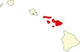
Maui County, officially the County of Maui, is a county in the U.S. state of Hawaii. It consists of the islands of Maui, Lānaʻi, Molokaʻi, Kahoʻolawe, and Molokini. The latter two are uninhabited. As of the 2020 census, the population was 164,754. The county seat is Wailuku.
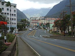
Wailuku is a census-designated place (CDP) in and county seat of Maui County, Hawaii, United States. The population was 17,697 at the 2020 census.

Makapuʻu is the extreme eastern end of the Island of Oʻahu in the Hawaiian Islands, comprising the remnant of a ridge that rises 647 feet (197 m) above the sea. The cliff at Makapuʻu Point forms the eastern tip and is the site of a prominent lighthouse. The place name of this area, meaning "bulging eye" in Hawaiian, is thought to derive from the name of an image said to have been located in a cave here called Keanaokeakuapōloli. The entire area is quite scenic and a panoramic view is presented at the lookout on Kalanianaole Highway where the roadway surmounts the cliff just before turning south towards leeward Oʻahu and Honolulu.
Wailua, Hawaiian for two waters, may refer to:
The following is an alphabetical list of articles related to the U.S. state of Hawaii:

The Air Force Maui Optical and Supercomputing observatory is an Air Force Research Laboratory (AFRL) operating location at Haleakala Observatory on Maui, Hawaii, with a twofold mission. First, it conducts the research and development mission on the Maui Space Surveillance System (MSSS) at the Maui Space Surveillance Complex (MSSC). Second, it oversees operation of the Maui High Performance Computing Center (MHPCC). AFRL's research and development mission on Maui was formally called Air Force Maui Optical Station (AMOS); the use of the term AMOS has been widespread throughout the technical community for over thirty years and is still used today at many technical conferences. The main-belt asteroid 8721 AMOS is named after the project.

The Hana Highway is a 64.4-mile-long (103.6 km) stretch of Hawaii Routes 36 and 360 which connects Kahului to the town of Hana in east Maui. To the east of Kalepa Bridge, the highway continues to Kipahulu as Hawaii Route 31. Although Hana is only about 52 miles (84 km) from Kahului, an uninterrupted car-trip takes about 2.5 hours to drive, since the highway is very windy, narrow, and passes over 59 bridges, of which 46 are only one lane wide. There are approximately 620 curves along Route 360 from just east of Kahului to Hana, almost all of it through lush, tropical rainforest. Many of the concrete and steel bridges date back to 1910 and all but one are still in use. That one bridge, badly damaged by erosion, has been replaced by a portable steel ACROW or Bailey bridge erected by the United States Army Corps of Engineers.

Mākena State Park comprises 165 acres (0.7 km2) in Makena, south of Wailea on the island of Maui, Hawaii. It contains three separate beaches and a dormant volcanic cinder cone.

The Battle of Kepaniwai was fought in 1790 between the islands of Hawaiʻi and Maui. The forces of Hawaiʻi were led by Kamehameha I, while the forces of Maui were led by Kalanikūpule. It is known as one of the most bitter battles fought in Hawaiian history.

This is a list of properties and historic districts in Hawaii listed on the National Register of Historic Places. More than 340 listings appear on all but one of Hawaii's main islands and the Northwestern Islands, and in all of its five counties. Included are houses, schools, archeological sites, ships, shipwrecks and various other types of listings. These properties and districts are listed by island, beginning at the northwestern end of the chain.

Wailua River State Park and the Wailua Complex of Heiaus, which it includes, are located on the eastern side of the Hawaiian island of Kauai. The park consists primarily of the Wailua River valley, which is the only navigable river in Hawaii. Visitors to this park can kayak, take riverboat cruises and explore the rainforest. Even motorboats and water skiing are permissible on the river.

Puʻunēnē is an unincorporated community in the central part of Maui, Hawaii, United States, near Kahului with a population of around 50. Although the land is fairly level, the Hawaiian language name Puʻu nēnē means "nēnē goose hill".

The Polipoli Spring State Recreation Area is a state park of Hawaiʻi in the United States. It is on the island of Maui about ten miles from Kula up the slope of Haleakalā.

Kaumahina State Wayside Park or Kaumahina State Park, is located in Maui County, Hawaii, 28.3 miles (45.5 km) East of Kahului and 22.4 miles (36.0 km) West of Hana along the Hana Highway. The park consists of 7.8 acres (32,000 m2) of forest and exotic plants. Amenities include a rest stop and scenic views of the northeast Maui coastline and Ke'anae Peninsula.
Puaʻa Kaʻa State Wayside Park is a state park on the island of Maui, Hawaiʻi. It is located along the Hana Highway approximately 39 mi (63 km) east of Kahului. The area consists of 5 acres (2.0 ha) of rainforest with waterfalls and pools. The park is at an elevation of 1,200 ft (370 m) and roughly 0.5 mi (0.80 km) away from Waiohue Bay.

Wailua is an unincorporated community in Maui County on the island of Maui in the state of Hawaii.
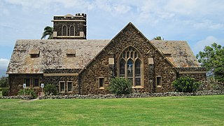
Makawao Union Church is a church near Makawao on the Hawaiian island of Maui. It was founded by New England missionary Jonathan Smith Green during the Kingdom of Hawaii. The third historic structure used by the congregation was designed by noted local architect C.W. Dickey and dedicated in 1917 as the Henry Perrine Baldwin Memorial Church. In 1985, Makawao Union Church was placed on the Hawaii and National Register of Historic Places.

Spreckelsville is an unincorporated community on the northern coast of the island of Maui in the U.S. state of Hawaii.
Helio Koa'eloa, was a Hawaiian Catholic lay missionary called as the "Apostle of Maui" for converting about 4,000 natives to the Catholic faith. Landmarks and memorials were dedicated to him at Maui. A cross was erected in Wailua valley in his memory in 1931.
