Thiruvananthapuram, commonly shortened to TVM or by its former name Trivandrum, is the capital city of the Indian state of Kerala. It is the most populous city in Kerala with a population of 957,730 as of 2011. The encompassing urban agglomeration population is around 1.68 million. Located on the west coast of India near the extreme south of the mainland, Thiruvananthapuram is a major information technology hub in Kerala and contributes 55% of the state's software exports as of 2016. Referred to by Mahatma Gandhi as the "Evergreen city of India", the city is characterised by its undulating terrain of low coastal hills.

The Kingdom of Travancore, also known as the Kingdom of Thiruvithamkoor or later as Travancore State, was an Indian kingdom that lasted from c. 1729 until 1949. It was ruled by the Travancore Royal Family from Padmanabhapuram, and later Thiruvananthapuram. At its zenith, the kingdom covered most of the south of modern-day Kerala and the southernmost part of modern-day Tamil Nadu with the Thachudaya Kaimal's enclave of Irinjalakuda Koodalmanikyam temple in the neighbouring Kingdom of Cochin. However Tangasseri area of Kollam city and Anchuthengu near Attingal in Thiruvananthapuram were parts of British India.

Neyyattinkara, is a significant municipal town and a prominent center for both industry and commerce, positioned at the southernmost tip of the Thiruvananthapuram metropolitan area in Trivandrum, the capital of Kerala State. It also serves as the administrative headquarters of Neyyattinkara Taluk.Nestled along the banks of the Neyyar River, one of the district's principal rivers, the town derives its name from its location, with 'Neyyatinkara' in Malayalam translating to 'the shore of the river Neyyar.' Neyyattinkara ranks as the second most densely populated municipality in the district, following Varkala. Notably, the Vizhinjam International Seaport Thiruvananthapuram is situated within Neyyattinkara Taluk."

Anizham Thirunal Marthanda Varma was the founding monarch of the southern Indian Kingdom of Travancore from 1729 until his death in 1758. He was succeeded by Rama Varma (1758–98). While he was the heir to the throne, he suggested to his uncle the idea of forming an alliance with the Mughal Nawab of Carnatic. Rama Varma pledged allegiance to the Mughal empire and embraced the title of "Zamindar of Malabar". The feudatory status of Travancore persisted even during the era of Hyder Ali.
Venad was a medieval kingdom lying between the Western Ghat mountains and the Arabian Sea on the south-western tip of India with its headquarters at the port city of Kollam/Quilon. It was one of the major principalities of Kerala, along with kingdoms of Kannur (Kolathunadu), Kozhikode (Nediyiruppu), and Kochi (Perumpadappu) in medieval and early modern period.

Thiruvananthapuram District is the southernmost district in the Indian state of Kerala. The district was created in 1949, with its headquarters in the city of Thiruvananthapuram, which is also Kerala's administrative centre. The present district was created in 1956 by separating the four southernmost Taluks of the erstwhile district to form Kanyakumari district. The city of Thiruvananthapuram is also known as the Information technology capital of the State, since it is home to the first and largest IT park in India, Technopark, established in 1990. The district is home to more than 9% of total population of the state.
Vizhinjam is an area located in the city of Thiruvananthapuram, the capital of the state of Kerala in India. Vizhinjam is the only village in Neyyattinkara Taluk which belongs to Thiruvananthapuram Corporation. It is located 16 km south west from the city centre and 17 km south of Trivandrum International Airport along NH66. Adani Ports (APSEZ), India’s biggest private port operator, is currently developing India's first deep water Transshipment Terminal Vizhinjam International Seaport Thiruvananthapuram in this area.

Kunnathur Kesavan Raman Pillai, also known as Raja Kesavadas was the Dewan of Travancore during the reign of Dharma Raja Karthika Thirunal Rama Varma. He is well known for his military tactics and administrative acumen. He was the mastermind in developing the Alappuzha town.
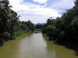
The Neyyar River is 56 km long river which flows through the Thiruvananthapuram district of Kerala in India. It flows from the Agastya Mala (Agastyarkoodam) in the Western Ghats. The town Neyyattinkara in Thiruvananthapuram district, is situated on the banks of the river, is named after this river. The river flows through the Neyyar wildlife sanctuary and into the Neyyar resorvoir. It then flows towards the west through the towns of Kallikkad, Kattakkada, Ottashekharamangalam, Keezharoor, Anavoor, Aruvipuram, Neyyantinkara and Thirupuram. The river then empties into the Arabian Sea at the Poovar estuary. Tributaries include the Kallar, Mullayar, and the Karavaliyar. It has several small canals along the river and the Neyyar Irrigation Project, "Neyyar Dam", is situated in this river. A safari park is located near the river. Neyyar river has been severely affected by sand mining.
Kanjiramkulam is an educational hub in Trivandrum Thiruvananthapuram district of Kerala State, India and is located on Thiruvananthapuram – Kanyakumari NH 66 bypass signal junction and in between Neyyattinkara, municipality – Vizhinjam International mother port. It is located 4.5 km from Neyyattinkara town and 22 km from the Kerala State capital Thiruvananthapuram. The Indian Postal PIN Code of this village is 695 524. The nearest railway station is Neyyattinkara Railway Station (6 km) and the nearest airport is Thiruvananthapuram International Airport (27 km). The people well educated and spread all over the world. Kanjiramkulam residence association is the registered NGO in panchayath. Major water source Kanjiramkulam pond.
Perumpazhuthoor is a village on the bank of Neyyar River, about 3 km away from the taluk municipality of Neyyattinkara in Thiruvananthapuram district in the Indian state of Kerala. This place lies on the road leading from Neyyattinkara towards the tourist attraction Neyyar Dam. This place is a pilgrim centre for Sri Narayana Guru pilgrim temple is situated here. The Sri Narayana Guru Temple is located at a lush green scenic spot on the Neyyar's shore.
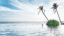
Pozhiyoor is a village in the district of Thiruvananthapuram in the State of Kerala in India. It has gradually grown to a well known tourist destination in India. The major attractions of Poovar tourism area are in Pozhiyoor. Pozhikkara, estuary formed by river Neyyar before it falls into the mighty Arabian Sea is the centre of attraction of tourism circuit in Poovar. Golden Beach, Elephant Rock, Anantha Victoria Marthanda Varma Canal, Pieta are other major attractions in Pozhiyoor Beach area in Thiruvananthapuram. It is at the coastal border of the Indian states of Kerala and Tamil Nadu.
Neyyattinkara is a Taluk (tehsil) located in the southern region of Thiruvananthapuram district, in the Indian state of Kerala. This taluk encompasses a total of 21 villages and one municipality, making it the southernmost taluk in the state. Notably, the Vizhinjam International Seaport Thiruvananthapuram is situated within Neyyattinkara Taluk."

The Vizhinjam International Seaport Thiruvananthapuram is India's first deep water container transshipment port, currently under-construction in Thiruvananthapuram, Kerala. It is a multi-purpose,all-weather, green port located 16 kilometres (9.9 mi) away from the Thiruvananthapuram International Airport. It is the first automated port in India and the only port in the country to be located adjacent to an international shipping route. The port is only 10 nautical miles (19 km) away from the busiest east–west shipping channel connecting Europe, Persian Gulf, South East Asia and the Far East. It is the only port in India with a natural depth of 20 meters, achieved without dredging. Being a greenfield seaport, it provides flexibility in design and future expansion.The port is a gateway to Indian Ocean. The seaport will be connected by India's third-longest railway tunnel, presently under planning phase.
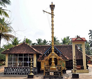
Neyyattinkara Sree Krishna Swamy Temple is a Hindu temple dedicated to Krishna situated at Neyyattinkara, 20 km (12 mi) south of Thiruvananthapuram in Kerala, India. It is one of the important temples of Krishna in Kerala with great historic importance. The temple enshrines Unnikannan in the form of Navaneetha Krishna as the presiding deity. Thrikkayyilvenna or Thrikkayyil Venna (butter) is a unique offering to Neyyattinkara Unnikannan, the deity of the temple. World famous musicians Sri. Neyyattinkara Mohanachandran and Neyyaattinkara Vasudevan used to perform concerts regularly in temple festival.
Parappanad was a former feudal city-state in Malabar, India. The headquarters of Parappanad Royal family was at the town Parappanangadi in present-day Malappuram district. In 1425, the country divided into Northern Parappanad and Southern Parappanad. Southern Parappanad included parts of Tirurangadi Taluk and the town Parappanangadi. Northern Parappanad included Panniyankara, Beypore, and Cheruvannur of Kozhikkode Taluk. Parappanad royal family is a cousin dynasty of the Travancore royal family.
Marthandanthurai is a coastal village on the shore of the Arabian Sea in Kanyakumari district, Tamil Nadu, India, near the border with Kerala and Tamil Nadu. The village is part of the Kollemcode panchayat. It belongs to the Roman Catholic Archdiocese of Trivandrum from 1967. Prior to joining with the Trivandrum Latin Archdiocese, this village was a part of the Roman Catholic Diocese of Cochin. The village is known for its beauty and versatility. It is a pilgrimage centre of Our Lady of Lourdu and is dedicated to the patronage of Our Lady of Dolours. The historical AVM Canal flows through this village. Its golden sand beach is the attraction of this tourist village. Being the part of Kollemcode Town Panchayat, this is the prime centre of trade and transportation for the neighboring villages. The 30% of people live in Marthandanthurai speak Malayalam as their major spoken language and the remainder speak a mixture of Tamil and Malayalam. In short, it can be said that people have their own colloquial way of talking and language. This language slang has big difference among neighbor regions and villages. Marthandanthurai the name sometimes referred as "Land of Marthanda Varma" because the king who did a lot of favors to this village. The villages of Vallavilai and Neerody are located near the village Marthandanthurai. This Village is located nearly 70 km from Kanyakumari and 30 km from Trivandrum.

]Cave pictures, probably by Neolithic people, are found in Pandavanpara, located in the North east side of Neyyattinkara towards Karakonam route. This famous cave will come under Perumkadavila panchayath. The name of this portion of land, before Marthanda Varma became the ruler of Travancore, was 'Thenganad'.
The Anantha-Victoria-Marthandam Canal a.k.a. A.V.M. Canal was conceived as a 'water link' between Thiruvananthapuram and Kanyakumari in July 1860 during the reign of Uthradam Thirunal Marthanda Varma Maharaja of Travancore state. Today it is the National Waterway 13 of India.

Ammachi Plavu literally translated from Malayalam, it means grandmother Jack-fruit tree or an old Jackfruit tree, Located in inside of Neyyattinkara Sree Krishna Swami Temple in Thiruvananthapuram Kerala.