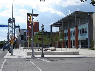
Welland is a city in the Regional Municipality of Niagara in Southern Ontario, Canada. As of 2021, it had a population of 55,750.

Port Colborne is a city in Ontario, Canada that is located on Lake Erie, at the southern end of the Welland Canal, in the Niagara Region of Southern Ontario. The original settlement, known as Gravelly Bay, dates from 1832 and was renamed after Sir John Colborne, a British war hero and the Lieutenant Governor of Upper Canada at the time of the opening of the (new) southern terminus of the First Welland Canal in 1833. The city's population in 2021 was 20,033.

The Welland Canal is a ship canal in Ontario, Canada, and part of the St. Lawrence Seaway and Great Lakes Waterway. The canal traverses the Niagara Peninsula between Port Weller on Lake Ontario, and Port Colborne on Lake Erie, and was erected because the Niagara River—the only natural waterway connecting the lakes—was unnavigable due to Niagara Falls. The Welland Canal enables ships to ascend and descend the Niagara Escarpment, and has followed four different routes since it opened.
King's Highway 58, commonly referred to as Highway 58, is a provincially maintained highway in the Canadian province of Ontario. The route is divided into two segments with a combined length of 15.5 km (9.6 mi). The southern segment travels from Niagara Regional Road 3, formerly Highway 3, in Port Colborne, to the Highway 58A junction in the southern end of Welland, a distance of 7.2 km (4.5 mi). The northern segment begins at Highway 20 near Allanburg and travels north and west to a large junction with Highway 406 at the St. Catharines – Thorold boundary, a distance of 8.3 km (5.2 mi). An 18.1 km (11.2 mi) gap separates the two segments within Welland and Pelham. The entire route is located within the Regional Municipality of Niagara.

King's Highway 3, commonly referred to as Highway 3, is a provincially maintained highway in the Canadian province of Ontario which travels parallel to the northern shoreline of Lake Erie. It has three segments, the first of which travels from the Ambassador Bridge in Windsor to Highway 77 in Leamington. The second portion begins at Talbotville Royal outside of St. Thomas at Highway 4, and travels to the western city limits of Port Colborne. The road is regionally maintained within Port Colborne as Niagara Regional Road 3, but regains its provincial designation at Highway 140. Its third and final terminus is at Edgewood Park, within the Fort Erie town limits. From there, the road continues as Niagara Regional Road 3 to the Peace Bridge, where drivers can cross to the United States. The total length of Highway 3 is 258.2 km (160.4 mi), consisting of 49.2 km (30.6 mi) from Windsor to Leamington, 187.9 km (116.8 mi) from Talbotville Royal to Port Colborne and 21.1 km (13.1 mi) from Port Colborne to Edgewood Park.

Niagara Centre is a federal electoral district in the Niagara Region of Ontario that has been represented in the House of Commons of Canada from 1867 to 1988 and since 1997.
King's Highway 140, commonly referred to as Highway 140, is a provincially maintained highway in the Canadian province of Ontario. The highway connects Port Colborne near Lake Erie with Highway 406 in Welland, via the Main Street Tunnel. It was constructed in the early 1970s as part of the Welland Bypass project of the Welland Canal, which resulted in the severance of several highways and rail lines. Opened to traffic in late 1972, several months following the tunnel, Highway 140 has remained unchanged since, despite growing calls to resign it as an extension of Highway 406.
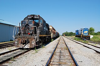
The Trillium Railway is a Canadian short-line railroad operating in the province of Ontario. Much of its right-of-way in the Niagara area was formerly part of the "Welland Canal Railway" that closely followed the route of the second Welland Canal.

The Niagara, St. Catharines and Toronto Railway was an interurban radial electric railway in the Niagara Peninsula of Southern Ontario, Canada. It operated from 1899 to 1959. It was based in St. Catharines and had lines to Niagara-on-the-Lake, Port Dalhousie, Niagara Falls, Thorold, Welland and Port Colborne.

The Port of Toronto is an inland port on the northwest shoreline of Lake Ontario in Toronto, Ontario, Canada. The port covers over 21 hectares of land on the eastern shore of the Toronto Harbour, in an area known as the Port Lands. The port includes several facilities, including Marine Terminal 51, Warehouse 52, and the International Marine Passenger Terminal. The Port of Toronto is operated by PortsToronto.

The Port Hope Panthers are a junior hockey team based in Port Hope, Ontario, Canada. They play in the Provincial Junior Hockey League of the Ontario Hockey Association.
The London and Lake Erie Railway and Transportation Company is a defunct Interurban railway that operated in Ontario, Canada from 1902 to 1918. Originally chartered as the South Western Traction Company, the line was renamed the London and Lake Erie Railway in 1909. Throughout its short life, the line was always referred to locally as "The Traction Line".
The Port Colborne Recreationists were a junior ice hockey team in the Ontario Hockey Association, based in Port Colborne, Ontario. The Recreationists played at the Junior B level through the 1940s, with the exception of one season.

Grimsby station is a railway station in Grimsby, Ontario, Canada. It is served by the Maple Leaf train between Toronto and New York City.

The Cape Government Railways 2-6-0ST of 1900 was a South African steam locomotive from the pre-Union era in the Cape of Good Hope.

The Port Elizabeth Harbour 0-4-0ST of 1894 was a South African steam locomotive from the pre-Union era in the Cape of Good Hope.

The Clarence Street Bridge is a vertical-lift bridge located in Port Colborne, Ontario. Built between 1927–1929 during 4th Welland Canal Construction, the bridge still serves today as a vital link connecting East and West Port Colborne. The structure uses simple electric motors and counterweights to raise the deck 36.5 meters (120ft.) above passing vessels. The raising and lowering of the bridge takes approximately 90 seconds. The western bridge approach, over former canal locks 26 and 27, was added when Bridge 21 was constructed, making these locks inoperable.
The Nerul–Uran line which is also known as Port line of the Mumbai Suburban Railway is a railway line serving between CBD Belapur and Nerul in Navi Mumbai with Uran in Navi Mumbai of India, which is attached to the Harbour line. It was inaugurated on 11 November 2018. Daily services started on 12 November 2018.