In the United States, a metropolitan statistical area (MSA) is a geographical region with a relatively high population density at its core and close economic ties throughout the region. Such regions are not legally incorporated as a city or town would be and are not legal administrative divisions like counties or separate entities such as states. As a result, sometimes the precise definition of a given metropolitan area will vary between sources. The statistical criteria for a standard metropolitan area were defined in 1949 and redefined as a metropolitan statistical area in 1983.

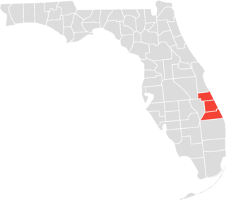
Port St. Lucie is a city in St. Lucie County, Florida, United States. It is the most populous municipality in the county and the seventh-most populous city in Florida with a population of 204,851 at the 2020 census. It is located 125 miles (201 km) southeast of Orlando and 113 miles (182 km) north of Miami. It is a principal city in the Port St. Lucie Metropolitan Statistical Area, which includes St. Lucie and Martin counties, and as of 2021 had an estimated population of 502,521. Port St. Lucie is also a principal city in the Miami-Fort Lauderdale-Port St. Lucie Combined Statistical Area, which had an estimated population of 6,841,100 as of 2021.
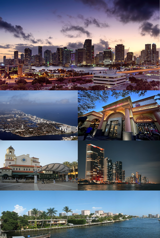
The Miami metropolitan area, also known as South Florida, SoFlo, SoFla, the Gold Coast, the Tri-County Area, or Greater Miami, and officially the Miami–Fort Lauderdale–West Palm Beach Metropolitan Statistical Area, is a coastal metropolitan area in southeastern Florida. It is the ninth-largest metropolitan statistical area (MSA) in the United States, the fifth-largest metropolitan area in the Southern United States, and the largest metropolitan area in Florida. With a population of 6.14 million, its population exceeds 31 of the nation's 50 states as of 2022. It comprises the three most populated counties in the state, Miami-Dade County, Broward County, and Palm Beach County, which rank as the first, second, and third-most populous counties in the state, respectively. Miami-Dade County, with 2,716,940 people in 2019, is the seventh-most populous county in the United States.
The Treasure Coast is a region in the southeast of the U.S. state of Florida. It borders the Atlantic Ocean and comprises Indian River, Martin, and St. Lucie counties. The region, whose name refers to the Spanish Treasure Fleet that was lost in a 1715 hurricane, evidently emerged from residents' desire to distinguish themselves from the Gold Coast to the south.
Combined statistical area (CSA) is a United States Office of Management and Budget (OMB) term for a combination of adjacent metropolitan (MSA) and micropolitan statistical areas (µSA) across the 50 U.S. states and the territory of Puerto Rico that can demonstrate economic or social linkage. CSAs were first designated in 2003. OMB defines a CSA by various combinations of adjacent metropolitan and micropolitan areas with economic ties measured by commuting patterns. CSAs retain their own designations as metropolitan or micropolitan statistical areas in their respective larger combined statistical areas.

Pennsylvania has 14 U.S. Census Bureau-designated metropolitan statistical areas (MSAs) and four combined statistical areas (CSAs). As of 2020, Philadelphia, the seventh-largest United States metropolitan area, is the state's largest metropolitan area followed by Pittsburgh and Allentown.

The Jacksonville Metropolitan Area, also called the First Coast, Metro Jacksonville, or Northeast Florida, is the metropolitan area centered on the principal city of Jacksonville, Florida and including the First Coast of North Florida. As of the 2020 United States census, the total population was 1,605,848. The Jacksonville–St. Marys–Palatka, FL–GA Combined Statistical Area (CSA) had a population of 1,733,937 in 2020 and was the 34th largest CSA in the United States. The Jacksonville metropolitan area is the 40th largest in the country and the fourth largest in the State of Florida, behind the Miami, Tampa, and Orlando metropolitan areas.

The Sarasota metropolitan area is a metropolitan area located in Southwest Florida. The metropolitan area is defined by the Office of Management and Budget (OMB) as the North Port–Bradenton–Sarasota Metropolitan Statistical Area, a metropolitan statistical area (MSA) consisting of Manatee County and Sarasota County. The principal cities listed by the OMB for the MSA are North Port, Bradenton, Sarasota, Lakewood Ranch, and Venice. At the 2020 census, the MSA had a population of 833,716. The Census Bureau estimates that its population was 891,411 in 2022.

The United States Office of Management and Budget has defined the 12-county Denver–Aurora, CO Combined Statistical Area comprising the Denver–Aurora–Lakewood, CO Metropolitan Statistical Area, the Boulder, CO Metropolitan Statistical Area, and the Greeley, CO Metropolitan Statistical Area. The United States Census Bureau estimates that the population was 3,214,218 as of July 1, 2012, an increase of +3.99% since the 2010 United States Census, and ranking as the 16th most populous metropolitan combined statistical area and the 17th most populous primary statistical area of the United States. The population estimate for 2020 was 3,652,385.

The U.S. State of Florida currently has 35 statistical areas that have been delineated by the Office of Management and Budget (OMB). On July 21, 2023, the OMB delineated 7 combined statistical areas, 22 metropolitan statistical areas, and 6 micropolitan statistical areas in Florida.
The Salisbury, MD-DE Metropolitan Statistical Area is a United States Census Bureau-designated metropolitan area centered in and around Salisbury, Maryland, including four counties: Somerset, Wicomico, and Worcester in Maryland; and Sussex in Delaware.
The Rockford Metropolitan Statistical Area, as defined by the United States Census Bureau, is an area consisting of four counties in north-central Illinois, anchored by the city of Rockford. As of the 2010 census, the MSA had a population of 349,431. The Rockford MSA abuts the southern portions of the Janesville-Beloit MSA and the Chicago MSA. It forms the main part of the larger Rockford–Freeport–Rochelle Combined Statistical Area.
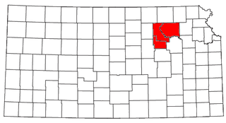
The Manhattan–Junction City Combined Statistical Area, as defined by the United States Census Bureau, is an area consisting of three counties in northeastern Kansas, anchored by the city of Manhattan. It was upgraded from a Micropolitan Statistical Area (μSA) to a Metropolitan Statistical Area (MSA) by the Office of Management and Budget on November 20, 2008. It was changed from a Metropolitan Statistical Area (MSA) to a Combined Statistical Area (CSA) by the Office of Management and Budget on February 28, 2013.

The Montgomery, Alabama Metropolitan Statistical Area is a metropolitan area in central Alabama. As of 2020, the MSA had a population of 386,047, ranking it 142nd among United States Metropolitan Statistical Areas. That number is up +3.07% from the 2010 census number of 374,536. In September of 2018 the OMB formed the Montgomery-Selma-Alexander City CSA. It's made up of the 4 county Montgomery MSA and the Selma, AL and Alexander City, AL micropolitan areas. The 7 county CSA has a population of 522,873 as of the 2020 census.

The Dothan–Enterprise–Ozark Combined Statistical Area was a CSA made up of five counties in the southeastern corner of the U.S. state of Alabama. The once statistical area includes one metropolitan area and originally one micropolitan area which then was split off as two. As of the 2010 census, the CSA had a population of 245,838. Currently an updated area called the Dothan-Ozark Combined Statistical area is used instead and Enterprise micropolitan area is now split as its own statistical area.

The Macon metropolitan area is a metropolitan statistical area consisting of five counties in Central Georgia, anchored by the principal city of Macon. At the 2010 U.S. census, the five-county area had a population of 232,293. A July 2017 estimate placed the population at 228,914. In 2022, its estimated population was 235,805.
The Kokomo Metropolitan Statistical Area, as defined by the United States Census Bureau, is an area consisting of Howard county in Indiana, anchored by the city of Kokomo. As of the 2000 census, the MSA had a population of 101,541. The official 2013 population estimate for the metro area is 82,760 people are in the Kokomo metropolitan area. The MSA formerly included Tipton County, Indiana. Kokomo is also the principal city of the area known as North Central Indiana, the area around Kokomo with economic ties. The six county area including Cass, Clinton, Fulton, Howard, Miami, and Tipton counties had population of 228,331 people in 2010.
