
The United States Army Corps of Engineers (USACE) is an engineer formation of the United States Army that has three primary mission areas: Engineer Regiment, military construction, and civil works. The day-to-day activities of the three mission areas are administered by a lieutenant general known as the commanding general/chief of engineers. The chief of engineers commands the Engineer Regiment, comprising combat engineer, rescue, construction, dive, and other specialty units, and answers directly to the Chief of Staff of the Army. Combat engineers, sometimes called sappers, form an integral part of the Army's combined arms team and are found in all Army service components: Regular Army, National Guard, and Army Reserve. Their duties are to breach obstacles; construct fighting positions, fixed/floating bridges, and obstacles and defensive positions; place and detonate explosives; conduct route clearance operations; emplace and detect landmines; and fight as provisional infantry when required. For the military construction mission, the commanding general is directed and supervised by the Assistant Secretary of the Army for installations, environment, and energy, whom the President appoints and the Senate confirms. Military construction relates to construction on military bases and worldwide installations.

Huntington is a city in Cabell and Wayne counties in the U.S. state of West Virginia. The county seat of Cabell County, the city is located at the confluence of the Ohio and Guyandotte rivers. Huntington is the second-largest city in West Virginia, with a population of 46,842 as of the 2020 census. Its metro area, the Huntington–Ashland metropolitan area, is the largest in West Virginia, spanning seven counties across three states and having a population of 376,155 at the 2020 census.

The Tennessee River is the largest tributary of the Ohio River. It is approximately 652 miles (1,049 km) long and is located in the southeastern United States in the Tennessee Valley. The river was once popularly known as the Cherokee River, among other names, as the Cherokee people had their homelands along its banks, especially in what are now East Tennessee and northern Alabama. Additionally, its tributary, the Little Tennessee River, flows into it from Western North Carolina and northeastern Georgia, where the river also was bordered by numerous Cherokee towns. Its current name is derived from the Cherokee town, Tanasi, which was located on the Tennessee side of the Appalachian Mountains.

The Intracoastal Waterway (ICW) is a 3,000-mile (4,800 km) inland waterway along the Atlantic and Gulf of Mexico coasts of the United States, running from Massachusetts southward along the Atlantic Seaboard and around the southern tip of Florida, then following the Gulf Coast to Brownsville, Texas. Some sections of the waterway consist of natural inlets, saltwater rivers, bays, and sounds, while others are artificial canals. It provides a navigable route along its length without many of the hazards of travel on the open sea.

The Gulf Intracoastal Waterway (GIWW) is the portion of the Intracoastal Waterway located along the Gulf Coast of the United States. It is a navigable inland waterway running approximately 1,300 mi (2,100 km) from Saint Marks, Florida, to Brownsville, Texas.

The Falls of the Ohio National Wildlife Conservation Area is a national, bi-state area on the Ohio River near Louisville, Kentucky in the United States, administered by the U.S. Army Corps of Engineers in partnership with Indiana Department of Natural Resources. Federal status was awarded in 1981. The falls were designated a National Natural Landmark in 1966.

The Kanawha River is a tributary of the Ohio River, approximately 97 mi (156 km) long, in the U.S. state of West Virginia. The largest inland waterway in West Virginia, its watershed has been a significant industrial region of the state since early in the 19th century.

An inland port is a port on an inland waterway, such as a river, lake, or canal, which may or may not be connected to the sea. The term "inland port" is also used to refer to a dry port.

The McAlpine Locks and Dam are a set of locks and a hydroelectric dam at the Falls of the Ohio River at Louisville, Kentucky. They are located at mile point 606.8, and control a 72.9 miles (117.3 km) long navigation pool. The locks and their associated canal were the first major engineering project on the Ohio River, completed in 1830 as the Louisville and Portland Canal, designed to allow shipping traffic to navigate through the Falls of the Ohio.

The inland waterways of the United States include more than 25,000 mi (40,000 km) of navigable waters. Much of the commercially important waterways of the United States consist of the Mississippi River System—the Mississippi River and connecting waterways.
Transport in the U.S. state of West Virginia is handled by the West Virginia Department of Transportation (WVDOT) which employs more than 6,000 in West Virginia.
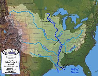
The Mississippi River System, also referred to as the Western Rivers, is a mostly riverine network of the United States which includes the Mississippi River and connecting waterways. The Mississippi River is the largest drainage basin in the United States. In the United States, the Mississippi drains about 59% of the country's rivers.

The history of turnpikes and canals in the United States began with work attempted and accomplished in the original thirteen colonies, predicated on European technology. After gaining independence, the United States grew westward, crossing the Appalachian Mountains with the admission of new states and then doubling in size with the Louisiana Purchase in 1803. The only means of transportation at the time between the coastal states and interior lands remained on water, by canoe, boat and ship, or over land on foot and by pack animal. Recognizing the success of Roman roads in unifying that empire, political and business leaders in the United States began to construct roads and canals to connect the disparate parts of the nation.
The Water Resources Development Act of 1986 is part of Pub. L.Tooltip Public Law 99–662, a series of acts enacted by Congress of the United States on November 17, 1986.
Rivers and Harbors Act may refer to one of many pieces of legislation and appropriations passed by the United States Congress since the first such legislation in 1824. At that time Congress appropriated $75,000 to improve navigation on the Ohio and Mississippi rivers by removing sandbars, snags, and other obstacles. Like when first passed, the legislation was to be administered by the United States Army Corps of Engineers (USACE), under its Chief Engineer and the Secretary of War.
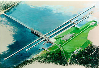
The Olmsted Locks and Dam is a locks and wicket dam on the Ohio River at river mile 964.4. The project is intended to reduce tow and barge delays by replacing the existing older, and frequently congested, locks and dams Number 52 and Number 53. The locks are located about 17 miles upstream from the confluence of the Ohio and Mississippi rivers at Olmsted, Illinois.

The Portland District is one of the five districts within the Northwestern Division of the United States Army Corps of Engineers. The Portland District is made up of some 1,100 civilian and 6 military personnel.
Port Freeport is the smallest (geographically) deep-water seaport along the U.S Gulf Coast. Located in Freeport, Texas . It has rail access, represents both private and public facilities. It is ranked 10th in the nation for chemicals, 19th in the nation for total tonnage, 26th in the nation for container traffic, handles over 100,000 vehicles per year and has more than 1,000 ships per year. Forbes magazine (2017) ranked Port Freeport as one of the top 10 fastest growing seaports for exports in the U.S.

The Port of Pittsburgh is a vast river traffic region in southwestern Pennsylvania. It spans a twelve-county area including Allegheny, Armstrong, Beaver, Blair, Butler, Clarion, Fayette, Greene, Indiana, Lawrence, Washington, and Westmoreland Counties.

The Sabine–Neches Waterway is located in southeast Texas and Calcasieu Parish, Louisiana, United States. The waterway includes parts of the Neches River, Sabine River, Sabine Lake, and Taylor Bayou. The waterway ranks as third-busiest waterway in the U.S. in terms of cargo tonnage, according to the American Association of Port Authorities. It also ranks as the top bulk liquid cargo waterway, the top U.S. crude-oil importer, and is projected to become the largest LNG exporter in the United States. The Gulf Intracoastal Waterway crosses the waterway near Port Arthur.
