List of ports in the United States

Last updated

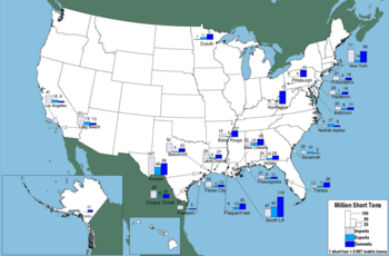
Top 25 water ports by tonnage Ports ranked by tonnage.png
Top 25 water ports by tonnage

This is a list of ports of the United States, ranked by tonnage. [1] Ports in the United States handle a wide variety of goods that are critical to the global economy, including petroleum, grain, steel, automobiles, and containerized goods. See the articles on individual ports for more information, including history, geography, and statistics.

Contents

Top 50 U.S. ports by tonnage

Cargo volume at U.S. ports, 2020, short tons [2]
Rank
(by total trade)
Port nameStateTotal tradeDomestic totalForeign totalForeign importsForeign exports
1 Port of Houston Texas 275,940,28979,177,826196,762,46356,970,738139,791,725
2 Port of South Louisiana Louisiana 225,086,697112,372,057112,714,64030,423,98482,290,656
3 Port of Corpus Christi Texas 150,755,48525,056,307125,699,17817,606,086108,093,092
4 Port of New York and New Jersey
Port Newark
New Jersey
New York
123,697,43840,087,79783,609,64168,357,07815,252,563
5 Port of New Orleans Louisiana 81,067,44843,220,21737,847,23115,324,11822,523,113
6 Port of Long Beach California 79,178,08713,490,35365,687,73446,552,10419,135,630
7 Port of Greater Baton Rouge Louisiana 71,686,87243,420,45828,266,4145,662,82722,603,587
8 Port of Beaumont Texas 70,567,38624,785,76145,781,62516,170,96029,610,665
9 Port of Los Angeles California 59,452,1394,501,36554,950,77438,658,36516,292,409
10 Port of Hampton Roads Virginia 58,048,7854,956,36953,092,41612,362,77340,729,643
11 Port of Mobile Alabama 53,206,56118,794,08334,412,47817,859,99916,552,479
12 Plaquemines Port Louisiana 46,750,79925,879,97120,870,8284,555,96916,314,859
13 Port of Savannah Georgia 43,453,0441,135,77742,317,26724,505,36617,811,901
14 Port of Lake Charles Louisiana 43,053,65820,333,50422,720,1545,026,40617,693,748
15 Port of Port Arthur Texas 41,222,20017,297,10823,925,0927,316,83516,608,257
16 Port Freeport Texas 38,748,6624,171,92534,576,7376,560,37728,016,360
17 Mid-Ohio Valley Port Ohio
West Virginia
35,939,47435,939,474000
18 Port of Baltimore Maryland 35,202,0274,211,84730,990,18012,937,13818,053,042
19 Ports of Cincinnati-Northern KY Ohio
Kentucky
34,476,34034,476,340000
20 Port of Texas City Texas 33,721,31212,540,97121,180,3417,601,30913,579,032
21 Port of St. Louis and East St. Louis Missouri
Illinois
30,487,79630,487,796000
22 Port of Huntington Tri-State West Virginia
Kentucky
Ohio
29,699,65729,699,657000
23 Port of Philadelphia Pennsylvania 28,517,76011,589,63416,928,1269,833,6807,094,446
24 Port of Tampa Bay Florida 28,511,76015,913,14812,598,6128,250,5234,348,089
25 Valdez Alaska 25,113,23123,019,7462,093,48502,093,485
26 Twin Ports of Duluth and Superior Minnesota
Wisconsin
25,071,11019,363,2385,707,872692,7765,015,096
27 Port of Charleston South Carolina 24,947,4821,822,97323,124,50914,996,0998,128,410
28 Northern Indiana Maritime District Indiana 24,684,06024,128,574555,486512,75942,727
29 Pascagoula Mississippi 23,096,7788,311,64514,785,1337,450,7887,334,345
30 Port of Seattle Washington 22,964,5464,814,77218,149,7749,098,1349,051,640
31 Port of Tacoma Washington 21,575,0594,186,84417,388,2155,794,81111,593,404
32 Port of Richmond California 21,050,7416,277,53814,773,20311,494,5543,278,649
33 Port of Portland Oregon 20,706,3456,391,34414,315,0012,218,43112,096,570
34 Port Everglades Florida 20,440,57311,177,7689,262,8056,498,5512,764,254
35 South Jersey New Jersey 20,254,3258,383,22911,871,09611,271,285599,811
36 Port of Oakland California 19,439,7621,313,83518,125,9278,520,1429,605,785
37 Kalama Washington 18,140,8861,393,41616,747,470328,88816,418,582
38 Port of Jacksonville Florida 16,701,3707,892,9868,808,3847,379,7151,428,669
39 Port of Pittsburgh Pennsylvania 15,536,05115,536,051000
40 New Bourbon Port Authority Missouri 15,506,75415,506,754000
41 Mid-America Port Iowa
Illinois
Missouri
14,952,34314,952,343000
42 Illinois Waterway Ports Illinois 14,946,03414,946,034000
43 Two Harbors Minnesota 13,499,84711,746,0911,753,75601,753,756
44 Port of Boston Massachusetts 13,322,5823,399,7789,922,8048,310,1011,612,703
45 Port of Honolulu Hawaii 12,261,50611,424,582836,924619,948216,976
46 Port of Galveston Texas 11,945,1825,242,6796,702,5031,525,0325,177,471
47 Port of Longview Washington 11,071,2851,145,3339,925,952338,1729,587,780
48 Port of Vancouver USA Washington 10,198,6022,557,9387,640,6641,128,6026,512,062
49 Port of Cleveland Ohio 9,442,7397,655,8271,786,9121,359,394427,518
50 Port of San Juan Puerto Rico 9,337,1634,611,7874,725,3764,285,535439,841

Unranked ports

Non-continental islands

Ports of non-continental islands
Port
State or territory GNIS
feature
ID #
and
reference
Link
Coordinates
Elevation
External
link
San Juan Puerto Rico 18°40′0.01″N66°10′0.01″W / 18.6666694°N 66.1666694°W / 18.6666694; -66.1666694 (San Juan (Puerto Rico))
Marina Puerto Chico, Fajardo Puerto Rico 1613388 18°20′54″N65°38′6″W / 18.34833°N 65.63500°W / 18.34833; -65.63500 (Fajardo (Puerto Rico)) 20 feet (6.1 m)
Port of Ponce Puerto Rico 18°0′4.54″N66°43′0.01″W / 18.0012611°N 66.7166694°W / 18.0012611; -66.7166694 (Port of Ponce (Puerto Rico))
Christiansted, St Croix, Virgin Islands Port Authority US Virgin Islands 17°45′9.76″N64°43′56.71″W / 17.7527111°N 64.7324194°W / 17.7527111; -64.7324194 (Christiansted, St. Croix (Virgin Islands))
Hilo Hawaii 19°43′43″N155°4′32.88″W / 19.72861°N 155.0758000°W / 19.72861; -155.0758000 (Hilo (Hawaii))
Kawaihae Harbor Hawaii 20°2′16.01″N155°49′59.88″W / 20.0377806°N 155.8333000°W / 20.0377806; -155.8333000 (Kawaihae Harbor (Hawaii))
Kahului Hawaii 20°53′55″N156°28′22.08″W / 20.89861°N 156.4728000°W / 20.89861; -156.4728000 (Kahului (Hawaii))
Port of Honolulu Hawaii 21°18′40″N157°52′18.12″W / 21.31111°N 157.8717000°W / 21.31111; -157.8717000 (Port of Honolulu (Hawaii))
Kalaeloa Hawaii 21°17′50.03″N158°6′32.04″W / 21.2972306°N 158.1089000°W / 21.2972306; -158.1089000 (Kalaeloa (Hawaii))
Nawiliwili Hawaii 21°57′40″N159°21′11.16″W / 21.96111°N 159.3531000°W / 21.96111; -159.3531000 (Nawiliwili (Hawaii)) )
Middle Ground harbor, Port of Guam Guam 1389888 13°27′17″N144°38′20″E / 13.45472°N 144.63889°E / 13.45472; 144.63889 (Middle Ground harbor, Port of Guam (Guam)) 0 feet (0 m)
Agat harbor, Port of Guam Guam 1934126 13°22′0″N144°38′53″E / 13.36667°N 144.64806°E / 13.36667; 144.64806 (Agat Harbor, Port of Guam (Guam)) 0 feet (0 m)
Ports of Saipan-Commonwealth Ports Authority of CNMI Northern Mariana Islands 15°13′33″N145°44′03″E / 15.22583°N 145.73417°E / 15.22583; 145.73417 (Port of Saipan (MP))

See also

Related Research Articles

<span class="mw-page-title-main">Department of transportation</span> Type of government agency responsible for transportation

A department of transportation is a government agency responsible for managing transportation. The term is primarily used in the United States to describe a transportation authority that coordinates or oversees transportation-related matters within its jurisdiction.

<span class="mw-page-title-main">League of American Bicyclists</span> Non-profit organization in the US

The League of American Bicyclists (LAB), officially the League of American Wheelmen, is a membership organization that promotes cycling for fun, fitness and transportation through advocacy and education. A Section 501(c)(3) nonprofit organization, the League is one of the largest membership organizations of cyclists in the United States.

<span class="mw-page-title-main">Historical regions of the United States</span>

The territory of the United States and its overseas possessions has evolved over time, from the colonial era to the present day. It includes formally organized territories, proposed and failed states, unrecognized breakaway states, international and interstate purchases, cessions, and land grants, and historical military departments and administrative districts. The last section lists informal regions from American vernacular geography known by popular nicknames and linked by geographical, cultural, or economic similarities, some of which are still in use today.

<span class="mw-page-title-main">America's Most Endangered Places</span> List by the U.S. National Trust for Historic Preservation

America's 11 Most Endangered Places or America's 11 Most Endangered Historic Places is a list of places in the United States that the National Trust for Historic Preservation considers the most endangered. It aims to inspire Americans to preserve examples of architectural and cultural heritage that could be "relegated to the dustbins of history" without intervention.

The following is a set–index article, providing a list of lists, for the cities, towns and villages within the jurisdictional United States. It is divided, alphabetically, according to the state, territory, or district name in which they are located.

The following radio stations broadcast on FM frequency 102.1 MHz:

The Water Resources Development Act of 1996 is part of Pub. L.Tooltip Public Law  104–303 (text)(PDF), was enacted by Congress of the United States on October 12, 1996. Most of the provisions of WRDA 1996 are administered by the United States Army Corps of Engineers.

The Water Resources Development Act of 1992, Pub. L.Tooltip Public Law  102–580, was enacted by Congress of the United States on October 31, 1992. Most of the provisions of WRDA 1992 are administered by the United States Army Corps of Engineers.

The Water Resources Development Act of 1999, Pub. L.Tooltip Public Law  106–53 (text)(PDF), was enacted by Congress of the United States on August 17, 1999. Most of the provisions of WRDA 1999 are administered by the United States Army Corps of Engineers.

The Water Resources Development Act of 2000, Pub. L.Tooltip Public Law  106–541 (text)(PDF), was enacted by Congress of the United States on December 11, 2000. Most of the provisions of WRDA 2000 are administered by the United States Army Corps of Engineers.

The following radio stations broadcast on FM frequency 88.7 MHz:

The following television stations operate on virtual channel 17 in the United States:
References

  1. "Port Industry Statistics". American Association of Port Authorities . Retrieved October 9, 2015.
  2. "Waterborne tonnage for principal U.S. ports and all 50 states and U.S. territories; Waterborne tonnages for domestic, foreign, imports, exports and intra-state waterborne traffic". U.S. Army Corps of Engineers. 2020. Retrieved March 14, 2023.

General references