Portage Des Sioux, Missouri

Last updated

Portage Des Sioux, Missouri
St. Charles County Missouri Incorporated and Unincorporated areas Portage Des Sioux Highlighted.svg
Location of Portage Des Sioux, Missouri
Portage-des-sioux.gif
U.S. Census map
Coordinates: 38°55′35″N90°20′35″W / 38.92639°N 90.34306°W / 38.92639; -90.34306
Country United States
State Missouri
County St. Charles
Area
[1]
  Total0.67 sq mi (1.75 km2)
  Land0.57 sq mi (1.49 km2)
  Water0.10 sq mi (0.26 km2)
Elevation
433 ft (132 m)
Population
 (2020)
  Total335
  Density582.61/sq mi (224.85/km2)
Time zone UTC-6 (Central (CST))
  Summer (DST) UTC-5 (CDT)
ZIP code
63373 [2]
Area code 636
FIPS code 29-59150 [3]
GNIS feature ID0756547 [4]
This water tower provides potable water to the town of Portage Des Sioux in St. Charles, Missouri. Portage Des Sioux Water Tower.jpg
This water tower provides potable water to the town of Portage Des Sioux in St. Charles, Missouri.

Portage Des Sioux is a city in St. Charles County, Missouri, United States. The town sits on the Mississippi River roughly opposite Elsah, Illinois, and is the home of the riverside shrine of Our Lady of the Rivers. The population was 328 at the 2010 census. The city was founded in 1799 by Spanish Lt. Gov. Zenon Trudeau and François Saucier in reaction to American plans to build a military post about twelve miles (19 km) downstream. The French name derives from the overland escape route between the Missouri River and Mississippi River used by a band of Sioux, fleeing enemies; they used this area as a portage for their canoes, [5] outdistancing their rivals who instead paddled all of the way to the confluence of the rivers.

Contents

The Treaties of Portage des Sioux in 1815 were signed here ostensibly settling Native American and United States conflicts in the War of 1812. The treaties consolidated and affirmed the Treaty of St. Louis (1804) in which the Sac and Fox ceding northeast Missouri and much of Illinois and Wisconsin and the 1808 Treaty of Fort Clark in which the Osage Nation ceded all of Missouri and Arkansas. These treaties were to ultimately result in the Black Hawk War and the tribes being forced to move west of Missouri.

Geography

According to the United States Census Bureau, the city has a total area of 0.53 square miles (1.37 km2), of which 0.45 square miles (1.17 km2) is land and 0.08 square miles (0.21 km2) is water. [6]

Demographics

Historical population
CensusPop.Note
1860 98
1870 16063.3%
1880 22540.6%
1900 242
1910 218−9.9%
1920 28329.8%
1930 248−12.4%
1940 2542.4%
1950 2643.9%
1960 37140.5%
1970 50937.2%
1980 488−4.1%
1990 5033.1%
2000 351−30.2%
2010 328−6.6%
2020 3352.1%
U.S. Decennial Census [7]

As of 2000 the median income for a household in the city was $38,333, and the median income for a family was $42,321. Males had a median income of $41,875 versus $25,000 for females. The per capita income for the city was $18,693. About 2.8% of families and 2.3% of the population were below the poverty line, including 4.0% of those under age 18 and none of those age 65 or over.

2010 census

As of the census [8] of 2010, there were 328 people, 136 households, and 90 families residing in the city. The population density was 728.9 inhabitants per square mile (281.4/km2). There were 166 housing units at an average density of 368.9 per square mile (142.4/km2). The racial makeup of the city was 98.5% White, 0.6% from other races, and 0.9% from two or more races. Hispanic or Latino of any race were 1.8% of the population.

There were 136 households, of which 28.7% had children under the age of 18 living with them, 52.2% were married couples living together, 7.4% had a female householder with no husband present, 6.6% had a male householder with no wife present, and 33.8% were non-families. 31.6% of all households were made up of individuals, and 9.5% had someone living alone who was 65 years of age or older. The average household size was 2.41 and the average family size was 3.02.

The median age in the city was 44.3 years. 22% of residents were under the age of 18; 7.6% were between the ages of 18 and 24; 21.3% were from 25 to 44; 38.8% were from 45 to 64; and 10.4% were 65 years of age or older. The gender makeup of the city was 51.2% male and 48.8% female.

Education

Public education in Portage Des Sioux is administered by the Orchard Farm School District. [9]

Portage Des Sioux had a public library, a branch of the St. Charles City-County District Library. It closed after flooding in 2019. [10]

Related Research Articles

<span class="mw-page-title-main">Missouri Valley, Iowa</span> City in Iowa, United States

Missouri Valley is a city in Harrison County, Iowa, United States. The population was 2,678 at the time of the 2020 census.

<span class="mw-page-title-main">Onawa, Iowa</span> City in Iowa, USA

Onawa is a city in, and the county seat of, Monona County, Iowa, United States. The population was 2,906 at the time of the 2020 Census. It is the largest town on the Iowa side of the Missouri River between Council Bluffs and Sioux City.

<span class="mw-page-title-main">Hornick, Iowa</span> City in Iowa, United States

Hornick is a city in Woodbury County, Iowa, United States. It is part of the Sioux City, IA–NE–SD metropolitan statistical area. The population was 255 at the time of the 2020 census.

<span class="mw-page-title-main">Sergeant Bluff, Iowa</span> City in Iowa, United States

Sergeant Bluff is a city in Woodbury County, Iowa, United States. It is part of the Sioux City, IA–NE–SD Metropolitan Statistical Area. The population was 5,015 at the time of the 2020 census.

<span class="mw-page-title-main">Smithland, Iowa</span> City in Iowa, United States

Smithland is a city in Woodbury County, Iowa, United States. It is part of the Sioux City, IA–NE–SD Metropolitan Statistical Area. The population was 181 at the time of the 2020 census.

<span class="mw-page-title-main">Sleepy Eye, Minnesota</span> City in Minnesota, United States

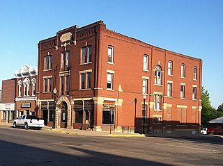
Sleepy Eye is a small city in rural Brown County, Minnesota, United States. The city is named after a famed local Dakota chief from the 1800s. The population was 3,599 at the 2010 census.

Hersey Township is a township in Nobles County, Minnesota, United States. The population was 257 at the 2000 census.

<span class="mw-page-title-main">Wabasha, Minnesota</span> City in Minnesota, United States

Wabasha is a city and the county seat of Wabasha County, Minnesota, United States. The population was 2,559 at the time of the 2020 census. It is on the Mississippi River, near its confluence with the Zumbro River.

<span class="mw-page-title-main">Washington, Missouri</span> City in Missouri, United States

Washington is a city on the south banks of the Missouri River, 50 miles west of St. Louis, Missouri, and the largest in Franklin County, Missouri, United States. The estimated population in July 2021 was 14,916, an increase of 7% since the 2010 census. It is the corncob pipe capital of the world, with Missouri Meerschaum located on the riverfront.

<span class="mw-page-title-main">Old Monroe, Missouri</span> City in Missouri, United States

Old Monroe is a city in Lincoln County, Missouri, United States. The population was 265 at the 2010 census.

<span class="mw-page-title-main">Bellefontaine Neighbors, Missouri</span> City in Missouri, United States

Bellefontaine Neighbors is an inner-ring suburb city in St. Louis County, Missouri, United States. The population was 10,860 at the 2010 census.

<span class="mw-page-title-main">Des Peres, Missouri</span> City in Missouri, United States

Des Peres is a city in west St. Louis County, Missouri, United States. The population was 8,373 at the 2010 census.

<span class="mw-page-title-main">South Sioux City, Nebraska</span> City in Dakota County, Nebraska, United States

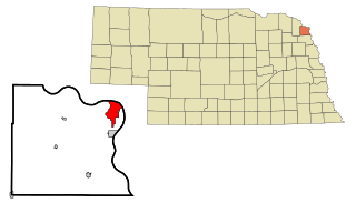
South Sioux City is a city in Dakota County, Nebraska, United States. It is located immediately across the Missouri River from Sioux City, Iowa, and is part of the Sioux City, IA-NE-SD Metropolitan Statistical Area. As of the 2010 census, the city population was 13,353, making it the 14th most populous city in Nebraska.

<span class="mw-page-title-main">Blair, Nebraska</span> City in and county seat of Washington County, Nebraska, United States

Blair is a city in and the county seat of Washington County, Nebraska, United States. The population was 7,990 at the 2010 census. Blair is a part of the Omaha-Council Bluffs Metropolitan Statistical Area.

<span class="mw-page-title-main">Fort Yates, North Dakota</span> City in Standing Rock Indian Reservation, United States

Fort Yates is a city in Sioux County, North Dakota, United States. It is the tribal headquarters of the Standing Rock Sioux Tribe and county seat of Sioux County. Since 1970 the population has declined markedly from more than 1,100 residents, as people have left for other locations for work. The population was 176 at the 2020 census.

<span class="mw-page-title-main">St. Marys, Ohio</span> City in Ohio, United States

St. Marys is a city in Auglaize County, Ohio, United States. Located in western Ohio, it is 11 miles (18 km) west of Wapakoneta and 20 miles (32 km) east of the Ohio–Indiana border. Founded in 1823, the city is located on a portage between the St. Marys and Auglaize river systems, which was a significant factor in its development before the era of canals. The population was 8,397 at the 2020 census. It is included in the Wapakoneta micropolitan area.

<span class="mw-page-title-main">Dell Rapids, South Dakota</span> City in South Dakota, United States

Dell Rapids is a city in Minnehaha County, South Dakota, United States. The population was 3,996 at the 2020 census. It is known as "The Little City with the Big Attractions."

<span class="mw-page-title-main">Fort Pierre, South Dakota</span> City in South Dakota, United States

Fort Pierre is a city in Stanley County, South Dakota, United States. It is part of the Pierre, South Dakota micropolitan area and the county seat of Stanley County. The population was 2,115 at the 2020 census.

<span class="mw-page-title-main">Plover, Wisconsin</span> Village in Wisconsin, United States

Plover is a village in Portage County, Wisconsin, United States. A suburb of Stevens Point, it is part of the Stevens Point Micropolitan Statistical Area. The population was 13,519 at the 2020 United States census.

<span class="mw-page-title-main">Dardenne Prairie, Missouri</span> Town in Missouri, United States

Dardenne Prairie is a city in St. Charles County, Missouri, United States. The population was 12,743 at the 2020 census.

References

  1. "ArcGIS REST Services Directory". United States Census Bureau. Retrieved August 28, 2022.
  2. "Portage Des Sioux MO ZIP Code". zipdatamaps.com. 2023. Retrieved June 16, 2023.
  3. "U.S. Census website". United States Census Bureau . Retrieved January 31, 2008.
  4. U.S. Geological Survey Geographic Names Information System: Portage Des Sioux, Missouri
  5. Eaton, David Wolfe (1918). How Missouri Counties, Towns and Streams Were Named. The State Historical Society of Missouri. pp.  356.
  6. "US Gazetteer files 2010". United States Census Bureau. Archived from the original on July 2, 2012. Retrieved July 8, 2012.
  7. "Census of Population and Housing". Census.gov. Retrieved June 4, 2015.
  8. "U.S. Census website". United States Census Bureau . Retrieved July 8, 2012.
  9. "City of Portage Des Sioux Missouri". InformationStLouis. Retrieved March 17, 2018.
  10. "Branches & hours". St. Charles City-County District Library. Retrieved March 17, 2018.