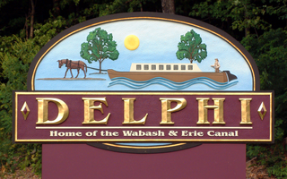
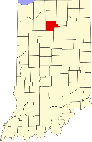
Delphi is a city in and the county seat of Carroll County, in the U.S. state of Indiana. Located twenty minutes northeast of Lafayette, it is part of the Lafayette, Indiana Metropolitan Statistical Area. The population was 2,893 at the 2010 census.

The Wabash River is a 503-mile-long (810 km) river that drains most of the state of Indiana in the United States. It flows from the headwaters in Ohio, near the Indiana border, then southwest across northern Indiana turning south near the Illinois border, where the southern portion forms the Indiana-Illinois border before flowing into the Ohio River.

The Wabash and Erie Canal was a shipping canal that linked the Great Lakes to the Ohio River via an artificial waterway. The canal provided traders with access from the Great Lakes all the way to the Gulf of Mexico. Over 460 miles long, it was the longest canal ever built in North America.

The Monon Trail is a rail trail located entirely within the state of Indiana. The Monon Railroad was a popular railroad line connecting the cities of Chicago and Indianapolis, with stops at major settlements along its route. After the decline of railroad travel and the sale of the company in 1987, the portion of the line between Indianapolis and Delphi, Indiana, was abandoned.
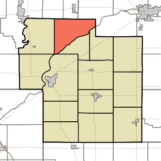
Adams Township is one of fourteen townships in Carroll County, Indiana. As of the 2010 census, its population was 516 and it contained 209 housing units.

The Jackson Covered Bridge also known as the Rockport Covered Bridge is located in the 'forgotten town' of Rockport, northwest of Bloomingdale, Parke County, Indiana, USA.
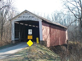
The Mill Creek Covered Bridge also known as "Thompson's Ford Covered Bridge," "Tow Path Covered Bridge," or "Earl Ray Covered Bridge" crosses Wabash Mill Creek (historic) southwest of Tangier, Indiana. It is a single span Burr Arch Truss covered bridge structure that was built by D. M. Brown in 1907.
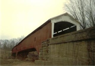
The West Union Covered Bridge formerly carried Tow Path Road over Sugar Creek north-northeast of Montezuma, Indiana. The two-span Burr Arch Truss covered bridge structure was built by Joseph J. Daniels in 1876. It is notable for being the longest standing covered bridge in Parke County, and one of the nation's best-preserved examples of the Burr truss.

Deer Creek Township is one of fourteen townships in Carroll County, Indiana. As of the 2010 census, its population was 4,571 and it contained 1,970 housing units.

The King Iron Bridge & Manufacturing Company was a late-19th-century bridge building company located in Cleveland, Ohio. It was founded by Zenas King (1818–1892) in 1858 and subsequently managed by his sons, James A. King and Harry W. King and then his grandson, Norman C. King, until the mid-1920s. Many of the bridges built by the company were used during America's expansion west in the late 19th century and early 20th century, and some of these bridges are still standing today.

Lee is an unincorporated community in Monon Township, White County, in the U.S. state of Indiana.

This is a list of the National Register of Historic Places listings in Carroll County, Indiana.
This is a list of the National Register of Historic Places listings in Fulton County, Indiana.

Daniel B. Luten also known as Daniel Benjamin Luten was an American bridge builder and engineer based in Indianapolis, Indiana.
The Vincennes Bridge Company, based in Vincennes, Indiana, was a designer and builder of bridges that was "one of Indiana's 'most successful bridge-building firms'".
The Delphi Courthouse Square Historic District in Delphi, Indiana is a 23-acre (9.3 ha) area roughly bounded by Monroe, Main, Market and Indiana Streets. It was listed on the National Register of Historic Places in 2010. It includes Italianate architecture and Classical Revival architecture and work by Elmer Dunlap among its 31 contributing buildings.

Centennial Neighborhood District is a national historic district located at Lafayette, Tippecanoe County, Indiana, United States. The area originated as the Bartholomew and Davis Additions to Lafayette in 1829. Growth came rapidly after the Wabash and Erie Canal arrived in 1843, and continued with the arrival of the railroad in 1853. The Centennial Neighborhood Historic District takes its name from the Centennial School, which was constructed in 1876 on the centennial of the nation. The school was located on the northeast corner of Brown Street at North 6th Street. It has since been removed and a park was created at its original location.

Downtown Lafayette Historic District is a national historic district located at Lafayette, Tippecanoe County, Indiana. Lafayette began in 1825 as a transportation center for the west central area of Indiana. Its development and growth reflects the changes in transportation over the intervening years. From its location along the Wabash River, it grew first with river travel then for a short while from the Wabash and Erie Canal. When the railroads arrived in the 1850s, the town began to grow, initially along the rail lines. The Downtown Lafayette Historic District reflects these early changes.

Wabash and Erie Canal Culvert #100, also known as Burnett's Creek Arch and County Bridge #181, is a historic culvert built for the Wabash and Erie Canal and located at Adams Township, Carroll County, Indiana. It was built in 1840, and is a semicircular span measuring 20 feet long, 10 feet high, and 87 feet, 6 inches wide. It is constructed of limestone slabs. The culvert now supports a county roadway.

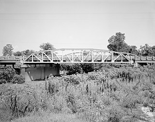
Deer Creek Valley Rural Historic District is a national historic district located in Deer Creek Township, Carroll County, Indiana. It encompasses 44 contributing buildings, 17 contributing sites, and 13 contributing structures on 20 historic properties near Delphi, Indiana. It includes several farmsteads, four cemeteries, two bridges, the Monon railroad right of way, the Delphi-Camden Road, and Deerk Creek and its slate bluffs. Notable farmsteads include the Mears Family Farmstead with a two-story Greek Revival style brick farmhouse.


