Related Research Articles

Gila County is in the central part of the U.S. state of Arizona. As of the 2020 census, the population was 53,272. The county seat is Globe.
Payson is a town in northern Gila County, Arizona, United States. Due to Payson's location being very near to the geographic center of Arizona, it has been called "The Heart of Arizona". The town is surrounded by the Tonto National Forest, the largest of the six national forests in Arizona and the ninth largest national forest in the United States.[1][2]

Star Valley is a town in Gila County, Arizona, United States, incorporated in 2005. Before incorporation, it was a census-designated place (CDP). As of the 2010 census the population of the town was 2,310.

Tonto Basin is a census-designated place (CDP) in Gila County, Arizona, United States. The population was 1,424 at the 2010 United States Census, up from 840 in 2000.

Rio Verde is a master-planned community just east of Scottsdale, in Arizona. It is also a census-designated place (CDP) in Maricopa County, Arizona, United States, located in the far, far northeast area of the whole Phoenix Metropolitan Area. The population was 2,210 as of the 2020 census, up from 1,811 at the 2010 census.

Golden Valley is an unincorporated area and census-designated place (CDP) in Mohave County, Arizona, United States. The population was 8,801 at the 2020 census.
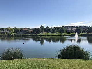
Queen Valley is a census-designated place (CDP) in north central Pinal County, Arizona, United States. The population was 820 at the 2000 census.

The Apache Trail in Arizona was a stagecoach trail that ran through the Superstition Mountains. It was named the Apache Trail after the Apache Indians who originally used this trail to move through the Superstition Mountains.

The Sierra Ancha is a mountain range in Gila County, in central Arizona. It lies between Roosevelt Lake to the south, the Tonto Basin to the west, Cherry Creek to the east, and Pleasant Valley to the north. The range is one of several, including the Bradshaw Mountains, Mingus Mountain of the Black Hills, and the Mazatzal Mountains, which form a transitional zone between the lowland deserts of southern Arizona and the Colorado Plateau of northeastern Arizona. The highest point in the range is Aztec Peak, at an elevation of 2345 m (7694 ft).

River aux Vases is an unincorporated community in Beauvais Township in Sainte Genevieve County, Missouri, United States.

State Route 188 is a 60.85-mile (97.93 km) state highway located primarily in Gila County in the U.S. state of Arizona.
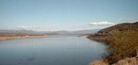
Theodore Roosevelt Lake is a large reservoir formed by Theodore Roosevelt Dam on the Salt River in Arizona as part of the Salt River Project (SRP). Located roughly 80 miles (130 km) northeast of Phoenix in the Salt River Valley, Theodore Roosevelt is the largest lake or reservoir located entirely within the state of Arizona. The reservoir and the masonry dam that created it, Roosevelt Dam, were both named after U.S. President Theodore Roosevelt who dedicated the dam himself on March 18, 1911. Roosevelt Lake is a popular recreation destination within the Tonto National Forest; the facilities located at this lake are managed by that authority.

The Mazatzal Mountains are a mountain range in south central Arizona, about 30–45 miles northeast of the Phoenix metropolitan area. The origin of the name remains obscure but one possibility is that it is from the Nahuatl language meaning "place of the deer". The crest of the Mazatzals forms the county line between Maricopa County and Gila County. SR 87, the Beeline Highway, traverses the Mazatzals on its way to Payson. The highest peak is Mazatzal Peak at 7,903 feet (2,409 m). They also include the Four Peaks, with elevation 7,659 ft, 2,334 m; a prominent mountain and landmark of the eastern Phoenix area.

The Tonto Basin, also known as Pleasant Valley, covers the main drainage basin of Tonto Creek and its tributaries in central Arizona, at the southwest of the Mogollon Rim, the higher elevation transition zone across central and eastern Arizona. Although the word tonto means silly or foolish in Spanish, this place name is derived from the Apache word, Koun’nde, which means wild, rough people and refers to the indigenous Dilzhe’e Tonto Apache.

Sunflower is a region of Maricopa County, Arizona, United States adjacent to the Mazatzal Wilderness, west of Tonto National Forest and northwest of Roosevelt Reservoir. Formerly a mercury-mining district, Sunflower is now a destination for hikers, campers and off-road vehicle tours. Sunflower is located near Arizona State Route 87, 22.8 miles (36.7 km) northeast of Fountain Hills. Route 87 near Sunflower is called the Beeline Highway.
The West Silver Bell Mountains are a small 10 mile (16 km) long mountain range of south-central Arizona, United States. The range lies in the north-central arid Sonoran Desert; the Madrean Sky Islands region of southeast Arizona, around Tucson is adjacent to the southeast.

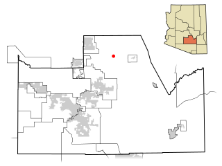
Deer Creek is a census-designated place in Gila County in the U.S. state of Arizona. Deer Creek is located almost directly between the community of Tonto Basin and the town of Payson near Arizona State Route 87. The population as of the 2010 U.S. Census was 216.
The Sevenmile Mountains are a mountain range in central Gila County in the U.S. state of Arizona. The range has a maximum elevation of 6,629 ft (2,021 m) and a prominence of 989 ft (301 m). The highest peak is labelled Seven on the USGS topo sheet and has a topographic isolation of 13.35 miles. The majority of the southern end of the range is located on the San Carlos Apache Indian Reservation. The high point and the northwestern tip of the range is in the Tonto National Forest and is open to free range hiking. The mountains' high point is located just 3 miles east from a section of the U.S. Route 60 in Arizona in between Globe, Arizona and Show Low, Arizona. The southern end of the range that is inside the San Carlos Apache Indian Reservation should only be hiked with permission from the Reservation. The range is one of many that occur in the Arizona transition zone.
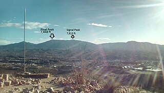
Pinal Peak, located in southern Gila County, Arizona, is the highest point in the Pinal Mountains, with an elevation of 7,848 feet (2,392 m). It is the highest point of land located in between the Salt and Gila rivers in Arizona before they merge, making it visible from miles away on a clear day. The peak ranks as the 11th most prominent in Arizona and has a topographic isolation of 35 miles (56 km), with the nearest point of land of equal or greater elevation being to the southeast in the Santa Teresa Mountains. Pinal Peak is slightly east of the approximate center of the Pinal Mountains. Despite being the most prominent peak in Gila County, it is not the highest point in the county. That title goes to Myrtle Point with an elevation between 7,963 and 8,003 feet (2,427–2,439 m), which lies atop the edge of the Mogollon Rim which forms the county line with Coconino County. The nearest population is in the Globe/Miami, Arizona area, just a few miles north of the range and peak.
Pembina is an unincorporated community in northern Christian County, in the U.S. state of Missouri. The community was located at the intersection of Missouri routes 125 and U, approximately 1.5 miles north of Linden and Finley Creek. The Pembina Cemetery is approximately one mile to the northwest, across Parched Corn Hollow in the center of Section 33.
References
- ↑ U.S. Geological Survey Geographic Names Information System: Punkin Center, Arizona
- ↑ Tonto Basin, AZ, 7.5 Minute Topographic Quadrangle, USGS, 2018
- ↑ Arizona Atlas & Gazetteer, DeLorme, 4th ed., 2002, p. 50 ISBN 0899333257
- ↑ Staff, KOLD News 13 Staff, Arizona's Family News. "U.S. Marshals capture escaped Tucson murder suspects". AZFamily. Retrieved November 16, 2019.
{{cite web}}: CS1 maint: multiple names: authors list (link) CS1 maint: numeric names: authors list (link)
