Tonto Basin, Arizona

Last updated

Tonto Basin, Arizona
Gila County Incorporated and Unincorporated areas Tonto Basin highlighted.svg
Location in Gila County and the state of Arizona
Usa edcp location map.svg
Red pog.svg
Tonto Basin, Arizona
Location in the United States
Coordinates: 33°50′24″N111°17′5″W / 33.84000°N 111.28472°W / 33.84000; -111.28472
Country United States
State Arizona
County Gila
Area
[1]
  Total32.13 sq mi (83.20 km2)
  Land32.12 sq mi (83.19 km2)
  Water0.00 sq mi (0.01 km2)
Elevation
2,238 ft (682 m)
Population
 (2020)
  Total1,444
  Density44.96/sq mi (17.36/km2)
Time zone UTC-7 (MST (no DST))
ZIP code
85553
Area code 928
FIPS code 04-74610
GNIS feature ID 1853170

Tonto Basin is a census-designated place (CDP) in Gila County, Arizona, United States. The population was 1,424 at the 2010 United States Census, [2] up from 840 in 2000.

Contents

Within Tonto Basin is located in the unincorporated community of Punkin Center.

History

The Pleasant Valley War (also sometimes called the Tonto Basin War or Feud) was an 1886 Arizona range war between two feuding families, the cattle-herding Grahams and the sheep-herding Tewksburys.

Geography

Tonto Basin is located in western Gila County at 33°50′24″N111°17′5″W / 33.84000°N 111.28472°W / 33.84000; -111.28472 (33.839953, -111.284734), [3] in the valley of Tonto Creek, a south-flowing tributary of the Salt River. Arizona State Route 188 passes through the community, leading southeast 49 miles (79 km) to Globe, the county seat, and north 30 miles (48 km) to Payson.

According to the United States Census Bureau, the Tonto Basin CDP has a total area of 31.3 square miles (81.1 km2), all land. [2]

Demographics

Historical population
CensusPop.Note
2020 1,444
U.S. Decennial Census [4]

As of the census [5] of 2000, there were 840 people, 439 households, and 262 families residing in the CDP. The population density was 26.8 inhabitants per square mile (10.3/km2). There were 726 housing units at an average density of 23.1 per square mile (8.9/km2). The racial makeup of the CDP was 96.1% White, 1.4% Native American, 0.9% from other races, and 1.6% from two or more races. 2.0% of the population were Hispanic or Latino of any race.

There were 439 households, out of which 9.1% had children under the age of 18 living with them, 51.0% were married couples living together, 7.1% had a female householder with no husband present, and 40.3% were non-families. 33.9% of all households were made up of individuals, and 16.9% had someone living alone who was 65 years of age or older. The average household size was 1.91 and the average family size was 2.38.

In the CDP, the population was spread out, with 10.4% under the age of 18, 3.6% from 18 to 24, 13.5% from 25 to 44, 39.9% from 45 to 64, and 32.7% who were 65 years of age or older. The median age was 58 years. For every 100 females, there were 107.4 males. For every 100 females age 18 and over, there were 103.0 males.

The median income for a household in the CDP was $23,398, and the median income for a family was $29,091. Males had a median income of $30,125 versus $17,500 for females. The per capita income for the CDP was $15,157. About 15.9% of families and 18.3% of the population were below the poverty line, including 16.9% of those under age 18 and 12.3% of those age 65 or over.

Notable person

See also

Related Research Articles

<span class="mw-page-title-main">Gila County, Arizona</span> County in Arizona, United States

Gila County is in the central part of the U.S. state of Arizona. As of the 2020 census, the population was 53,272. The county seat is Globe.

<span class="mw-page-title-main">Canyon Day, Arizona</span> CDP in Gila County, Arizona

Canyon Day is a census-designated place (CDP) in Gila County, Arizona, United States, on the Fort Apache Indian Reservation. The population was 1,209 at the 2010 census.

<span class="mw-page-title-main">Central Heights-Midland City, Arizona</span> CDP in Gila County, Arizona

Central Heights-Midland City is an unincorporated community and census-designated place (CDP) in Gila County, Arizona, United States. The area is home to the Pinal Cemetery which serves the community in gereneral but also contains Croatian and Serbian dedicated sections. The Gila County Health and Human Services offices are located within the region. One of the communities few nurseries is located along Golden Hill Road, a notable road in the Central Heights-Midland City area. The population was 2,534 at the 2010 census.

<span class="mw-page-title-main">Claypool, Arizona</span> CDP in Gila County, Arizona

Claypool is a census-designated place (CDP) in Gila County, Arizona, United States. The population was 1,538 at the 2010 census, down from 1,794 at the 2000 census. It was named after W. D. Claypool, a member of both the State House of Representatives and State Senate in the 1910s and 1920s.

<span class="mw-page-title-main">Gisela, Arizona</span> CDP in Gila County, Arizona

Gisela is an unincorporated community and census-designated place (CDP) in Gila County, Arizona, United States. The population was 570 at the 2010 census.

<span class="mw-page-title-main">Peridot, Arizona</span> CDP in Gila and Graham Counties, Arizona, US

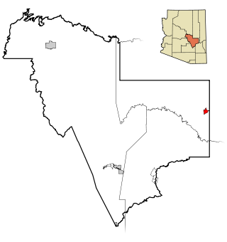
Peridot is an unincorporated community and census-designated place (CDP) in Gila and Graham counties in the U.S. state of Arizona. The population was 1,350 at the 2010 census.

<span class="mw-page-title-main">Pine, Arizona</span> CDP in Gila County, Arizona

Pine is an unincorporated community and census-designated place (CDP) in Gila County, Arizona, United States. The population was 1,963 at the 2010 census. Pine was established by four Mormon families in 1879.

<span class="mw-page-title-main">San Carlos, Arizona</span> CDP in Gila County, Arizona

San Carlos is a census-designated place (CDP) in Gila County, Arizona, United States. The population was 4,038 at the 2010 census, up from 3,716 in 2000.

<span class="mw-page-title-main">Strawberry, Arizona</span> CDP in Gila County, Arizona

Strawberry is an unincorporated community and census-designated place (CDP) in Gila County, Arizona, United States. The population was 961 at the 2010 census.

<span class="mw-page-title-main">Star Valley, Arizona</span> Town in Gila County, Arizona

Star Valley is a town in Gila County, Arizona, United States, incorporated in 2005. Before incorporation, it was a census-designated place (CDP). As of the 2010 census the population of the town was 2,310.

<span class="mw-page-title-main">Rio Verde, Arizona</span> CDP in Maricopa County, Arizona

Rio Verde is a master-planned community just east of Scottsdale, in Arizona. It is also a census-designated place (CDP) in Maricopa County, Arizona, United States, located in the far, far northeast area of the whole Phoenix Metropolitan Area. The population was 2,210 as of the 2020 census, up from 1,811 at the 2010 census.

<span class="mw-page-title-main">Sun Lakes, Arizona</span> CDP in Maricopa County, Arizona

Sun Lakes is an unincorporated community and census-designated place (CDP) in Maricopa County, Arizona, United States. The population was 14,868 at the 2020 census. Sun Lakes is an active adult community comprising five country club communities in three homeowner associations. These include the gated communities of Oakwood and IronWood (IronOaks), the gated and non-gated communities of Palo Verde and Cottonwood, and the non-gated community of Sun Lakes 1. Sun Lakes is a master-planned community developed by Robson Communities.

<span class="mw-page-title-main">Sells, Arizona</span> CDP in Pima County, Arizona

Sells is an unincorporated community and census-designated place (CDP) in Pima County, Arizona, United States. The population was 2,799 at the 2000 census. It is the capital of the Tohono O'odham Nation and the home of several of their tribal businesses, such as Tohono O'Odham Ki:Ki Association. Originally named Indian Oasis, by cattle-ranchers/businessmen brothers, Joseph and Louis Ménager in 1912. The Ménager brothers also built and ran the Indian Oasis Mercantile Store. The settlement took its present English name in 1918 to honor Indian Commissioner Cato Sells. The O'odham name means "Tortoise Got Wedged".

<span class="mw-page-title-main">Three Points, Arizona</span> CDP in Arizona, United States

Three Points is a census-designated place (CDP) in Pima County, Arizona, United States. The population was 5,581 at the 2010 census.

<span class="mw-page-title-main">Tortolita, Arizona</span> Former CDP in Arizona, United States

Tortolita was a census-designated place (CDP) in Pima County, Arizona, United States. The population was 3,740 at the 2000 census. Tortolita was situated between the growing incorporated towns of Oro Valley and Marana with most of the area previously part of the CDP having been annexed by the two towns during the 2000s. The remaining parts of the CDP that have not been annexed continue to be unincorporated portions of Pima County.

<span class="mw-page-title-main">Blackwater, Arizona</span> CDP in Pinal County, Arizona

Blackwater is a native village and census-designated place (CDP) on the Gila River Reservation in Pinal County, Arizona, United States. The population was 1,062 at the 2010 census, up from 504 in 2000.

<span class="mw-page-title-main">Queen Valley, Arizona</span> CPD in Pinal County, Arizona

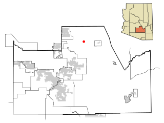
Queen Valley is a census-designated place (CDP) in north central Pinal County, Arizona, United States. The population was 820 at the 2000 census.

<span class="mw-page-title-main">Sacaton, Arizona</span> CDP in Pinal County, Arizona

Sacaton is a census-designated place (CDP) in Pinal County, Arizona, United States. The population was 3,254 at the 2020 census. It is the capital of the Gila River Indian Community.

<span class="mw-page-title-main">Lake Goodwin, Washington</span> Former CDP in Washington, United States

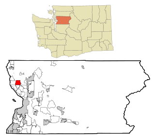
Lake Goodwin is a former census-designated place (CDP) in Snohomish County, Washington, United States. The population was 3,354 at the 2000 census. The CDP was discontinued at the 2010 census.

<span class="mw-page-title-main">Gold Canyon, Arizona</span> Census-designated place in Arizona, United States

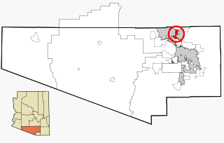
Gold Canyon is a census-designated place (CDP) and unincorporated community in Pinal County, Arizona, United States. The community is sometimes incorrectly called Gold Camp.

References

  1. "2020 U.S. Gazetteer Files". United States Census Bureau. Retrieved October 29, 2021.
  2. 1 2 "Geographic Identifiers: 2010 Demographic Profile Data (G001): Tonto Basin CDP, Arizona". U.S. Census Bureau, American Factfinder. Retrieved November 3, 2016.[ dead link ]
  3. "US Gazetteer files: 2010, 2000, and 1990". United States Census Bureau. February 12, 2011. Retrieved April 23, 2011.
  4. "Census of Population and Housing". Census.gov. Retrieved June 4, 2016.
  5. "U.S. Census website". United States Census Bureau . Retrieved January 31, 2008.
  6. 1 2 Burnham, Frederick Russell (1926). Scouting on Two Continents. New York: Doubleday, Page and Co. Chapters 3 & 4. ASIN B000F1UKOA.
  7. R. R. Money (April 1962). "Tonto Basin Feud". Blackwood's Magazine . 291. ISSN   0006-436X.
  8. "Tonto Basin Outlaws (1941)". Internet Movie Database. Retrieved July 7, 2007.