Related Research Articles
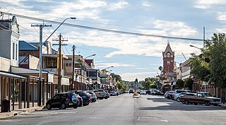
Broken Hill is an inland mining city in the far west of outback New South Wales, Australia. It is near the border with South Australia on the crossing of the Barrier Highway (A32) and the Silver City Highway (B79), in the Barrier Range. It is 315 m (1,033 ft) above sea level, with a hot desert climate, and an average rainfall of 235 mm (9 in). The closest major city is Adelaide, the capital of South Australia, which is more than 500 km (311 mi) to the southwest and linked via route A32.

Glenrock Lagoon, an intermediate freshwater small coastal creek, is located within the Lake Macquarie local government area in the Newcastle and Hunter regions of New South Wales, Australia. The lake is located near the Newcastle suburbs of Adamstown and Dudley and is situated about 153 kilometres (95 mi) north of Sydney.

The Far West region of New South Wales, Australia refers generally to a fairly flat and low-lying area in the western part of the state, which is too dry to support wheat or other crops or intensive pastoral endeavours. It is west of the North West Slopes, Central West and the Riverina. It is an area with limited rainfall, and the only major rivers found in it are the Darling River and the Murray River, which originate in the Great Dividing Range to the east. The region corresponds to the combination of the Australian Bureau of Meteorology's forecast areas of Upper Western and Lower Western. It also corresponds to the Western Division established under the New South Wales Western Lands Act 1901.

The lands administrative divisions of New South Wales refers to the 141 counties within the Colony of New South Wales, that later became the Australian state of New South Wales.

Lands administrative divisions of Australia are the cadastral divisions of Australia for the purposes of identification of land to ensure security of land ownership. Most states term these divisions as counties, parishes, hundreds, and other terms. The eastern states of Queensland, New South Wales, Victoria and Tasmania were divided into counties and parishes in the 19th century, although the Tasmanian counties were renamed land districts in the 20th century. Parts of South Australia (south-east) and Western Australia (south-west) were similarly divided into counties, and there were also five counties in a small part of the Northern Territory. However South Australia has subdivisions of hundreds instead of parishes, along with the Northern Territory, which was part of South Australia when the hundreds were proclaimed. There were also formerly hundreds in Tasmania. There have been at least 600 counties, 544 hundreds and at least 15,692 parishes in Australia, but there are none of these units for most of the sparsely inhabited central and western parts of the country.

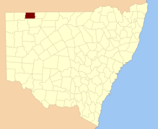
Yancowinna County is one of the 141 Cadastral divisions of New South Wales.

Henry Dangar was a surveyor and explorer of Australia in the early period of British colonisation. He became a successful pastoralist and businessman, and also served as a magistrate and politician. He was born on 18 November 1796 at St Neot, Cornwall, United Kingdom, and was the first of six brothers to emigrate as free settlers to New South Wales. From 1845 to 1851 Dangar was a Member of the New South Wales Legislative Council.
Barraba is a town in the New England region of northern New South Wales, Australia. It was formerly the centre of Barraba Shire local government area, but most of this, including Barraba, was absorbed into Tamworth Regional Council in 2004. On Census night 2016, Barraba had a population of approximately 1,400 people. It is part of the Bundarra-Barraba Important Bird Area which is important for the conservation of the endangered regent honeyeater.

Durham Downs Station most commonly known as Durham Downs is a pastoral lease that operates as a cattle station in Durham, Shire of Bullo in South West Queensland, Australia. The property is situated in a remote and arid location along Cooper Creek where it often experiences drought and floods. It was originally established in the 1870s and now belongs to the Kidman family. In the 1940s, overgrazing by wild horses left little food for stock and led to the implementation of a culling program.
Frost Parish is a civil parish of Narromine County, New South Wales

Bolwarry, New South Wales is a civil parish of Tongowoko County, New South wales. The parish is east of Tibooburra.
Albert Parish located at 32°00'54.0"S 141°08'29.0"E is a remote rural locality, and cadastral Parish of Yancowinna County, far western New South Wales. The parish is on the Barrier Highway midway between Broken Hill, New South Wales and Cockburn on the South Australian border.
Toorawandi is a civil parish of Napier County in New South Wales.
Connulpie, New South Wales is a remote civil Parish, of the County of Delalah a cadasteral division of New South Wales.

Thackaringa is a rural locality, civil Parish, railway stop and Cattle Station in Far Western New South Wales.
Naradin is a rural locality in Far western New South Wales and a civil parish of Yancowinna County.
Wallarunga is a rural locality and ghost town located at -32.031799316 and 141.317901611 about 10 Kilometers south west of Broken Hill, New South Wales.
Burns, New South Wales is a village in the Unincorporated Far West of New South Wales.
Yancowinna County is a rural locality in Unincorporated Far West and a civil parish of Yancowinna County in far western New South Wales.
Robe, Yancowinna County is a civil parish of Yancowinna County in Far Western New South Wales. The parish is located near Purnamoota north of Broken Hill.
References
- ↑ Map of the County of Yancowinna, Western Division N.S.W., Land District of Willyama / compiled, drawn & printed at the Department of Lands, Sydney, N.S.W.
- ↑ Purnamoota (Purnamoota Station), Yancowinna Co., New South Wales, Australia.
- 1 2 Map of Purnamoota, NSW.
- ↑ David R Horton (creator), © Aboriginal Studies Press, AIATSIS, and Auslig/Sinclair, Knight, Merz, 1996.
- ↑ "History." Broken Hill: Accessible Outback. 2007, Edition 15, p4.
- 1 2 John Beer reports "Explore Australia" 11th Edition 1993 produced by Viking O'Neil published by Penguin Books shows on Pg 114:- 1.
- 1 2 3 4 The Commercial Banking Company of Sydney Limited.
- ↑ Monthly Archives: September 2016.