Yancowinna County

Last updated

Map all coordinates using: OpenStreetMap  
Download coordinates as: KML
Yancowinna
New South Wales
Yancowinna NSW.PNG
Location in New South Wales
Lands administrative divisions around Yancowinna:
South Australia Farnell Mootwingee
South Australia Yancowinna Tandora
South Australia Menindee Tandora
Yancowinna, shown in a map from 1886 Yancowinna County 1886.jpg
Yancowinna, shown in a map from 1886

Yancowinna County is one of the 141 Cadastral divisions of New South Wales.

The county contains the city of Broken Hill (in Picton Parish) and village of Silverton (in Umberumberka Parish). The County also has the hamlets of Wallarunga/The Pinnacles and Burns; and the ghost towns of Tarrawingee and Purnamoota.

Some New South Wales industrial relations laws have excluded the county of Yancowinna. [1] The county is also the only part of New South Wales which is in the same time zone as South Australia (UTC+09:30 rather than UTC+10:00). [2]

The name Yancowinna is believed to be derived from a local Aboriginal word and is also the name of the location within the county of Yancowinna Glen. [3]

Parishes

A full list of parishes found within this county; their current LGA and mapping coordinates to the approximate centre of each location is as follows:

ParishLGACoordinates
Albert Unincorporated Far West 32°00′54″S141°08′29″E / 32.01500°S 141.14139°E / -32.01500; 141.14139 (Albert)
Aldborough Unincorporated Far West 32°14′09″S141°51′49″E / 32.23583°S 141.86361°E / -32.23583; 141.86361 (Aldborough)
Alma Unincorporated Far West 32°00′29″S141°21′49″E / 32.00806°S 141.36361°E / -32.00806; 141.36361 (Alma)
Barrier Unincorporated Far West 32°09′24″S141°38′10″E / 32.15667°S 141.63611°E / -32.15667; 141.63611 (Barrier)
Bolaira Unincorporated Far West 31°57′47″S141°32′30″E / 31.96306°S 141.54167°E / -31.96306; 141.54167 (Bolaira)
Bomangaldy Unincorporated Far West 31°49′58″S141°11′11″E / 31.83278°S 141.18639°E / -31.83278; 141.18639 (Bomangaldy)
Bray Unincorporated Far West 31°57′37″S141°15′19″E / 31.96028°S 141.25528°E / -31.96028; 141.25528 (Bray)
Cambellia Unincorporated Far West
Carrington Unincorporated Far West 31°49′58″S141°04′34″E / 31.83278°S 141.07611°E / -31.83278; 141.07611 (Carrington)
Cathcart Unincorporated Far West 31°47′09″S141°35′28″E / 31.78583°S 141.59111°E / -31.78583; 141.59111 (Cathcart)
Coombarra Unincorporated Far West 32°09′22″S141°28′29″E / 32.15611°S 141.47472°E / -32.15611; 141.47472 (Coombarra)
Coonbaralla Unincorporated Far West 32°03′22″S141°49′46″E / 32.05611°S 141.82944°E / -32.05611; 141.82944 (Coonbaralla)
Dhoon Unincorporated Far West 32°07′55″S141°08′39″E / 32.13194°S 141.14417°E / -32.13194; 141.14417 (Dhoon)
Edgar Unincorporated Far West 32°03′01″S141°14′28″E / 32.05028°S 141.24111°E / -32.05028; 141.24111 (Edgar)
Elti Unincorporated Far West 31°42′07″S141°05′33″E / 31.70194°S 141.09250°E / -31.70194; 141.09250 (Elti)
Fairy Hill Unincorporated Far West 31°39′52″S141°47′55″E / 31.66444°S 141.79861°E / -31.66444; 141.79861 (Fairy Hill)
Farmcoat Unincorporated Far West 32°05′13″S141°40′35″E / 32.08694°S 141.67639°E / -32.08694; 141.67639 (Farmcoat)
Hughes Unincorporated Far West 32°12′09″S141°25′49″E / 32.20250°S 141.43028°E / -32.20250; 141.43028 (Hughes)
Inkerman Unincorporated Far West 31°52′21″S141°54′45″E / 31.87250°S 141.91250°E / -31.87250; 141.91250 (Inkerman)
Jamieson Unincorporated Far West 31°53′33″S141°04′35″E / 31.89250°S 141.07639°E / -31.89250; 141.07639 (Jamieson)
Lewis Unincorporated Far West 31°45′14″S141°24′00″E / 31.75389°S 141.40000°E / -31.75389; 141.40000 (Lewis)
Maharatta Unincorporated Far West 31°51′14″S141°46′46″E / 31.85389°S 141.77944°E / -31.85389; 141.77944 (Maharatta)
Matong Unincorporated Far West 31°49′05″S141°50′09″E / 31.81806°S 141.83583°E / -31.81806; 141.83583 (Matong)
Meadows Unincorporated Far West 31°39′39″S141°05′32″E / 31.66083°S 141.09222°E / -31.66083; 141.09222 (Meadows)
Moorkaie Unincorporated Far West 31°49′09″S141°38′47″E / 31.81917°S 141.64639°E / -31.81917; 141.64639 (Moorkaie)
Mount Gipps Unincorporated Far West 31°46′30″S141°29′16″E / 31.77500°S 141.48778°E / -31.77500; 141.48778 (Mount Gipps)
Mundi Mundi Unincorporated Far West 31°44′19″S141°13′24″E / 31.73861°S 141.22333°E / -31.73861; 141.22333 (Mundi Mundi)
Myalla Unincorporated Far West 31°44′04″S141°55′39″E / 31.73444°S 141.92750°E / -31.73444; 141.92750 (Myalla)
Nadbuck Unincorporated Far West 31°56′45″S141°21′41″E / 31.94583°S 141.36139°E / -31.94583; 141.36139 (Nadbuck)
Naradin Unincorporated Far West 31°53′06″S141°21′39″E / 31.88500°S 141.36083°E / -31.88500; 141.36083 (Naradin)
Narran Unincorporated Far West 32°07′38″S141°47′26″E / 32.12722°S 141.79056°E / -32.12722; 141.79056 (Narran)
Ophara Unincorporated Far West 32°07′55″S141°02′50″E / 32.13194°S 141.04722°E / -32.13194; 141.04722 (Ophara)
Picton Unincorporated Far West, Broken Hill 31°54′34″S141°28′11″E / 31.90944°S 141.46972°E / -31.90944; 141.46972 (Picton)
Purnamoota Unincorporated Far West 31°35′48″S141°27′50″E / 31.59667°S 141.46389°E / -31.59667; 141.46389 (Purnamoota)
Redan Unincorporated Far West 32°14′30″S141°44′56″E / 32.24167°S 141.74889°E / -32.24167; 141.74889 (Redan)
Robe Unincorporated Far West 31°39′21″S141°21′11″E / 31.65583°S 141.35306°E / -31.65583; 141.35306 (Robe)
Sebastopol Unincorporated Far West 32°03′39″S141°33′25″E / 32.06083°S 141.55694°E / -32.06083; 141.55694 (Sebastopol)
Sentinel Unincorporated Far West 32°10′36″S141°14′49″E / 32.17667°S 141.24694°E / -32.17667; 141.24694 (Sentinel)
Soudan Unincorporated Far West 32°05′14″S141°26′11″E / 32.08722°S 141.43639°E / -32.08722; 141.43639 (Soudan)
Stephen Unincorporated Far West 31°48′38″S141°22′04″E / 31.81056°S 141.36778°E / -31.81056; 141.36778 (Stephen)
Stratford Unincorporated Far West 32°02′21″S141°42′30″E / 32.03917°S 141.70833°E / -32.03917; 141.70833 (Stratford)
Tara Unincorporated Far West 31°54′39″S141°37′29″E / 31.91083°S 141.62472°E / -31.91083; 141.62472 (Tara)
Thackaringa Unincorporated Far West 31°57′42″S141°06′21″E / 31.96167°S 141.10583°E / -31.96167; 141.10583 (Thackaringa)
Umberumberka Unincorporated Far West 31°50′07″S141°16′29″E / 31.83528°S 141.27472°E / -31.83528; 141.27472 (Umberumberka)
Victoria Unincorporated Far West 32°04′16″S141°02′47″E / 32.07111°S 141.04639°E / -32.07111; 141.04639 (Victoria)
Waukeroo Unincorporated Far West 31°41′05″S141°33′48″E / 31.68472°S 141.56333°E / -31.68472; 141.56333 (Waukeroo)
Yancowinna East Unincorporated Far West 31°38′59″S141°54′54″E / 31.64972°S 141.91500°E / -31.64972; 141.91500 (Yancowinna East)
Yancowinna North Unincorporated Far West 31°39′40″S141°40′49″E / 31.66111°S 141.68028°E / -31.66111; 141.68028 (Yancowinna North)
Yancowinna Unincorporated Far West 31°45′29″S141°43′04″E / 31.75806°S 141.71778°E / -31.75806; 141.71778 (Yancowinna)
Yangalla Unincorporated Far West 31°36′56″S141°14′23″E / 31.61556°S 141.23972°E / -31.61556; 141.23972 (Yangalla)

Related Research Articles

Cumberland County, New South Wales Cadastral in New South Wales, Australia

Cumberland County is a county in the State of New South Wales, Australia. Most of the Sydney metropolitan area is located within the County of Cumberland.

Supreme Court of New South Wales Superior court of New South Wales, Australia

The Supreme Court of New South Wales is the highest state court of the Australian State of New South Wales. It has unlimited jurisdiction within the state in civil matters, and hears the most serious criminal matters. Whilst the Supreme Court is the highest New South Wales court in the Australian court hierarchy, an appeal by special leave can be made to the High Court of Australia.

Time in Australia Time zones in Australia

Australia uses three main time zones: Australian Western Standard Time, Australian Central Standard Time, and Australian Eastern Standard Time. Time is regulated by the individual state governments, some of which observe daylight saving time (DST). Australia's external territories observe different time zones.

Industrial Court of New South Wales

The Industrial Court of New South Wales was a court within the Australian court hierarchy that exercised the judicial functions of the Industrial Relations Commission of New South Wales within the Australian state of New South Wales. The Commission has exclusive jurisdiction in respect of industrial disputes in that state.

Lands administrative divisions of New South Wales

For lands administrative purposes, New South Wales is divided into 141 counties, which are further divided into parishes. The counties were first set down in the Colony of New South Wales, which later became the Australian state of New South Wales.

Lands administrative divisions of Australia Cadastral divisions of Australia for land identification purposes

Lands administrative divisions of Australia are the cadastral divisions of Australia for the purposes of identification of land to ensure security of land ownership. Most states term these divisions as counties, parishes, hundreds, and other terms. The eastern states of Queensland, New South Wales, Victoria, and Tasmania were divided into counties and parishes in the 19th century, although the Tasmanian counties were renamed land districts in the 20th century. Parts of South Australia (south-east) and Western Australia (south-west) were similarly divided into counties, and there were also five counties in a small part of the Northern Territory. However South Australia has subdivisions of hundreds instead of parishes, along with the Northern Territory, which was part of South Australia when the hundreds were proclaimed. There were also formerly hundreds in Tasmania. There have been at least 600 counties, 544 hundreds and at least 15,692 parishes in Australia, but there are none of these units for most of the sparsely inhabited central and western parts of the country.

Gloucester County, New South Wales Cadastral in New South Wales, Australia

Gloucester County was one of the original Nineteen Counties in New South Wales, and is now one of the 141 cadastral divisions of New South Wales. It includes the area around Port Stephens. It is bounded on the north and west by the Manning River, and on the south-west by the Williams River.

King County, New South Wales Cadastral in New South Wales, Australia

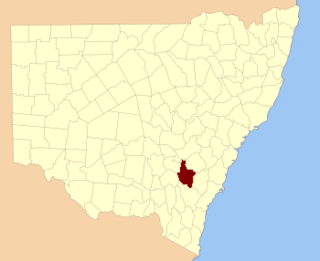
King County was one of the original Nineteen Counties in New South Wales and is now one of the 141 cadastral divisions of New South Wales. It is in the area to the east of Yass. The northern part of it lies between the Lachlan River and the Boorowa River, including the locations of Frogmore, Taylors Flat, Gunnary, Rugby and Rye Park. The Crookwell River is also part of the northern boundary. The Yass River is the southern boundary.

Sandon County Cadastral in New South Wales, Australia

Sandon County is one of the 141 Cadastral divisions of New South Wales. It is centred on Armidale, and also includes Uralla.

Barrona County Cadastral in New South Wales, Australia

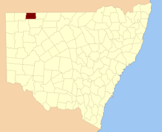
Barrona County is one of the 141 Cadastral divisions of New South Wales. It is bounded by the Warrego River in the east and the Paroo River in the west.

Cowper County Cadastral in New South Wales, Australia

Cowper County, New South Wales is one of the 141 Cadastral divisions of New South Wales.

Delalah County Cadastral in New South Wales, Australia

Delalah County is one of the 141 Cadastral divisions of New South Wales.

Kennedy County Cadastral in New South Wales, Australia

Kennedy County is one of the 141 Cadastral divisions of New South Wales. It is located to the west of the Bogan River in the area around Tottenham and Tullamore.

Killara County Cadastral in New South Wales, Australia

Killara County is one of the 141 Cadastral divisions of New South Wales. The Darling River is its south eastern boundary.

Mootwingee County Cadastral in New South Wales, Australia

Mootwingee County, New South Wales is one of the 141 cadastral divisions of New South Wales.

Thoulcanna County Cadastral in New South Wales, Australia

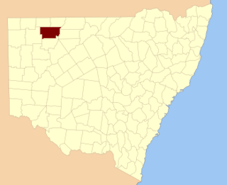
Thoulcanna County is one of the 141 Cadastral divisions of New South Wales. It is located south of the border with Queensland, to the west of the Paroo River near Wanaaring in the Bourke Shire.

Ularara County Cadastral in New South Wales, Australia

Ularara County is one of the 141 Cadastral divisions of New South Wales. It is located to the west of the Paroo River.

Yantara County Cadastral in New South Wales, Australia

Yantara County is one of the 141 Cadastral divisions of New South Wales.

Yungnulgra County Cadastral in New South Wales, Australia

Yungnulgra County is one of the 141 Cadastral divisions of New South Wales.

Hermidale Village in New South Wales, Australia

Hermidale is a village in the Orana region of New South Wales, Australia. It is 600km north-west of Sydney and the two closest towns are Nyngan and Cobar. It lies on the Barrier Highway. In 2011, its population, including the surrounding area, was 302. The population of the village only was 137 in the 2016 Census.

References

  1. "NSW Office of Industrial Relations: Awards Online". www.industrialrelations.nsw.gov.au. Archived from the original on 27 September 2007. Retrieved 22 March 2008.
  2. "New South Wales". www.greenwichmeantime.com. Retrieved 22 March 2008.
  3. "Yancowinna". Geographical Names Register (GNR) of NSW. Geographical Names Board of New South Wales . Retrieved 11 August 2013. OOjs UI icon edit-ltr-progressive.svg
Map all coordinates using: OpenStreetMap  
Download coordinates as: KML