Elmhurst is a neighborhood in the borough of Queens in New York City. It is bounded by Roosevelt Avenue on the north; the Long Island Expressway on the south; Junction Boulevard on the east; and the New York Connecting Railroad on the west.

Kew Gardens is a neighborhood in the central area of the New York City borough of Queens. Kew Gardens is bounded to the north by the Union Turnpike and the Jackie Robinson Parkway, to the east by the Van Wyck Expressway and 131st Street, to the south by Hillside Avenue, and to the west by Park Lane, Abingdon Road, and 118th Street. Forest Park is to the west and the neighborhood of Forest Hills to the north-west, Flushing Meadows–Corona Park north, Richmond Hill south, Briarwood southeast, and Kew Gardens Hills east.

Woodhaven is a neighborhood in the southwestern section of the New York City borough of Queens. It is bordered on the north by Park Lane South and Forest Park, on the east by Richmond Hill, on the south by Ozone Park and Atlantic Avenue, and the west by the Cypress Hills neighborhood of Brooklyn.

Maspeth is a residential and commercial community in the borough of Queens in New York City. It was founded in the early 17th century by Dutch and English settlers. Neighborhoods sharing borders with Maspeth are Woodside to the north; Sunnyside to the northwest; Greenpoint, Brooklyn to the west; East Williamsburg, Brooklyn to the southwest; Fresh Pond and Ridgewood to the south; and Middle Village and Elmhurst to the east.

Glendale is a neighborhood in the west-central portion of the New York City borough of Queens. It is bounded by Forest Hills to the east, Ridgewood to the west, Woodhaven to the south, and Middle Village to the north.

Richmond Hill is a commercial and residential neighborhood located in the southeastern section of the New York City borough of Queens. The area borders Kew Gardens and Forest Park to the north, Jamaica and South Jamaica to the east, South Ozone Park to the south, and Woodhaven and Ozone Park to the west. The neighborhood is split between Queens Community Board 9 and 10.

Middle Village is a mainly residential neighborhood in the central section of the borough of Queens, New York City, bounded to the north by the Long Island Expressway, to the east by Woodhaven Boulevard, to the south by Cooper Avenue and the former LIRR Montauk Branch railroad tracks, and to the west by Mount Olivet Cemetery. The small trapezoid-shaped area bounded by Mt. Olivet Crescent to the east, Fresh Pond Road to the west, Eliot Avenue to the north, and Metropolitan Avenue to the south is often counted as part of Middle Village, but is sometimes considered part of nearby Ridgewood.

Ridgewood is a neighborhood in the New York City borough of Queens. It borders the Queens neighborhoods of Maspeth to the north, Middle Village to the east, and Glendale to the southeast, as well as the Brooklyn neighborhoods of Bushwick to the southwest and East Williamsburg to the west. Historically, the neighborhood straddled the Queens-Brooklyn boundary.
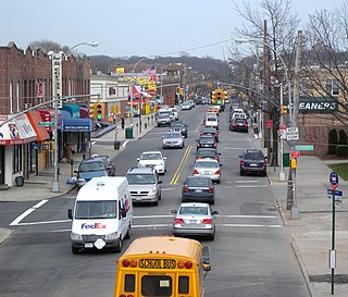
Woodhaven Boulevard and Cross Bay Boulevard are two parts of a major boulevard in the New York City borough of Queens. Woodhaven Boulevard runs roughly north–south in the central portion of Queens. South of Liberty Avenue, it is known as Cross Bay Boulevard, which is the main north–south road in Howard Beach. Cross Bay Boulevard is locally known as simply "Cross Bay", and Woodhaven Boulevard, "Woodhaven". The completion of the boulevard in 1923, together with the construction of the associated bridges over Jamaica Bay, created the first direct roadway connection to the burgeoning Atlantic Ocean beachfront communities of the Rockaway Peninsula from Brooklyn and most of Queens.

The Grand Street Line is a public transit line in Brooklyn and Queens, New York City, running mostly along the continuous Grand Street and Grand Avenue between Williamsburg, Brooklyn and Maspeth, Queens. It then continues down Queens Boulevard to the 63rd Drive–Rego Park station. Originally a streetcar line, it is now the Q59 bus route, operated by the New York City Transit Authority between Williamsburg and Rego Park, Queens.

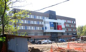
Queens Gateway to Health Sciences Secondary School is a school in the New York City borough of Queens which places emphasis on the health sciences. The school serves grades 6–12. Previously co-located in other school buildings, the school moved to its current building for the 2010–11 school year.

The Q38 is a bus route in Queens, New York City. The route travels from the Corona and Elmhurst neighborhoods to the Forest Hills neighborhood, running in a "C" shape via the Metropolitan Avenue station in Middle Village. It runs seven days a week but does not operate overnight. Formerly privately operated by Triboro Coach Corporation, the route is now city-operated under the MTA Bus Company brand of MTA Regional Bus Operations.
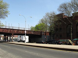
Woodhaven Junction was a station complex on the Atlantic Branch and Rockaway Beach Branch of the Long Island Rail Road, located at Atlantic Avenue between 98th and 100th Streets in Woodhaven, Queens, New York City. The elevated Rockaway Beach station was closed in 1962 along with the rest of the branch, while the underground Atlantic Branch station was closed and abandoned on January 7, 1977.
Brooklyn Manor was a station on the Long Island Rail Road's Rockaway Beach Branch located on the south side of Jamaica Avenue at 100th Street, straddling the border between Richmond Hill and Woodhaven in Queens, New York City. The station name referred to the nearby Brooklyn Manor section of Woodhaven, originally a 603-lot development bounded by Woodhaven Boulevard to the west, 96th/98th Streets to the east, Forest Park to the north, and Jamaica Avenue to the south. The station opened in January 1911, and was constructed as a replacement for the Brooklyn Hills station, which was located 3,000 feet (910 m) to the north. This station closed along with the rest of the Rockaway Beach Branch in 1962, and was subsequently demolished.

Fresh Pond was a small middle class neighborhood in the New York City borough of Queens, separated from Juniper Valley by the Lutheran and Mount Olivet cemeteries. In present day, it is now considered part of the surrounding neighborhoods of Maspeth, Middle Village, Glendale, and Ridgewood and is no longer referred to by the name "Fresh Pond." The area was originally named for two freshwater ponds that, in the early 1900s, were filled in. Other ponds were lower, and brackish due to Newtown Creek being estuarine.
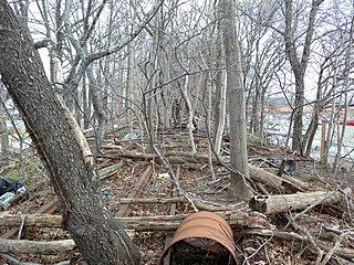
Parkside is a former elevated Long Island Rail Road (LIRR) station on the north side of Metropolitan Avenue on the border of the Rego Park, Forest Hills, and Glendale neighborhoods in Queens, New York City. Opened in 1927, the wooden station was part of the Rockaway Beach Branch and was the northernmost station on the branch before the junction with the Main Line at Rego Park Station and the terminus of the line at Grand Street station in Elmhurst. It also had a connecting spur to the Montauk Branch east towards Richmond Hill station. The station was closed in 1962, twelve years after the LIRR had abandoned the Rockaway portions of the line.
Metropolitan Avenue is a major east-west street in Queens and northern Brooklyn, New York City. Its western end is at the East River in Williamsburg, Brooklyn, and the eastern end at Jamaica Avenue in Jamaica, Queens. The avenue was constructed in 1816 as the Williamsburgh and Jamaica Turnpike, though previously it served as an Indian trail.

Glendale was a Long Island Rail Road station along the Lower Montauk Branch, located in Glendale, Queens at Edsall Avenue and 73rd Street, near Central Avenue, at the All Faiths Monuments factory for the All Faiths Cemetery. This station had two "platforms" which were just strips of pavement besides the tracks signed as the station, and two tracks.

Maspeth High School is a public high school in Elmhurst, Queens. The school opened in September 2013 with 273 students at the Metropolitan Avenue Campus in Forest Hills, Queens and serves primarily students from NYC District 24 in Northern Queens. Maspeth High School is a traditional, open enrollment, district public school. Currently Maspeth High School serves grades 9-12 and has 1,209 students. Maspeth High School has over 40 clubs and 27 varsity sports teams. Maspeth's teams are known as the Argonauts.

The Q11, Q21, Q52, and Q53 bus routes constitute a public transit corridor running along Woodhaven and Cross Bay Boulevards in Queens, New York City. The corridor extends primarily along the length of the two boulevards through "mainland" Queens, a distance of 6 miles (9.7 km) between Elmhurst and the Jamaica Bay shore in Howard Beach. The Q52 and Q53 buses, which provide Select Bus Service along the corridor, continue south across Jamaica Bay to the Rockaway peninsula, one of the few public transit options between the peninsula and the rest of the city.