
The Free State is a province of South Africa. Its capital is Bloemfontein, which is also South Africa's judicial capital. Its historical origins lie in the Boer republic called the Orange Free State and later Orange Free State Province.

Fouriesburg is a small town situated at the junction of the R711 and R26 routes in the eastern Free State, South Africa. It is near the Maluti Mountains and only 10 km from Caledon's Poort border post, which gives access to Lesotho.
Harrismith is a large town in the Free State province of South Africa. It was named for Sir Harry Smith, a 19th-century British governor and high commissioner of the Cape Colony. It is situated by the Wilge River, alongside the N3 highway, about midway between Johannesburg, about 300 km to the north-west, and Durban to the southeast. The town is located at the junction of the N5 highway, which continues westward towards the provincial capital Bloemfontein, some 340 km to the south-west. This important crossroads in South Africa's land trade routes is surrounded by mesas and buttes. It is located at the base of one of these called Platberg.

The R23 is a provincial route in South Africa that links Benoni with Volksrust via Brakpan, Heidelberg and Standerton.

The R26 is a provincial route in Free State, South Africa that connects Zastron with Villiers via Bethlehem.

The R57 is a provincial route in South Africa that connects Vanderbijlpark with Phuthaditjhaba via Sasolburg, Heilbron and Reitz.

The R59 is a provincial route in South Africa that connects Hertzogville with Alberton via Bothaville, Parys and Vereeniging. The R59 is a freeway from the R57 Junction in Sasolburg until the Alberton N12 Reading Interchange, signposted as the Sybrand van Niekerk Freeway.

The R71 is a provincial route in Limpopo, South Africa that connects Polokwane with the Kruger National Park via the major towns of Tzaneen and Phalaborwa.

The R74 is a provincial route in South Africa that connects Harrismith with KwaDukuza on the coast, via Oliviershoek Pass, Bergville, Winterton, Colenso, Weenen and Greytown.

The R76 is a provincial route in Free State, South Africa that connects Orkney with Bethlehem via Kroonstad.
The R365 is a Regional Route in South Africa that connects Piketberg and Lamberts Bay.

The N4 is a national route in South Africa that runs from Skilpadshek on the Botswana border, past Rustenburg, Pretoria, eMalahleni and Mbombela, to Komatipoort on the Mozambique border. It forms the South African section of the Trans-Kalahari Corridor, which runs from Walvis Bay to Maputo, meaning that it links the east and west coasts of Southern Africa. Since the completion of the A2 through Botswana, the entire Corridor is now a world-class standard highway; it features at least one carriageway in each direction of high-speed traffic plus a paved shoulder for its entire length.

Golden Gate Highlands National Park is located in Free State, South Africa, near the Lesotho border. It covers an area of 340 km2 (130 sq mi). The park's most notable features are its golden, ochre, and orange-hued, deeply eroded sandstone cliffs and outcrops, especially the Brandwag rock. Another feature of the area is the numerous caves and shelters displaying San rock paintings. Wildlife featured at the park includes mongooses, eland, zebras, and over 100 bird species. It is the Free State's only national park, and is more famous for the beauty of its landscape than for its wildlife. Numerous paleontology finds have been made in the park, including dinosaur eggs and skeletons.
The N5 is a national route in South Africa that connects the N1 at Winburg with the N3 at Harrismith, via Senekal, Paul Roux and Bethlehem.

Saskatchewan Highway 711 connects Saskatchewan Highway 35 in the Wellington rural municipality (RM) to Saskatchewan Highway 9 in the Wawken RM. The beginning terminus is just south of Cedoux. The length of Highway 711 is 142.1 kilometres (88.3 mi) and it extends westward, in the south-eastern area of Saskatchewan northeast of Weyburn. Osage and Corning are the only communities along the route.
The QwaQwa National Park is part of the Golden Gate Highlands National Park and the Maloti-Drakensberg Park and comprises the former Bantustan (homeland) of QwaQwa. It is approximately 60 km from Harrismith on the Golden Gate Road (R712) and formed an integral part of the Highlands Treasure Route.
Dihlabeng Local Municipality is an administrative area in the Thabo Mofutsanyane District of the Free State in South Africa. It was established in terms of Section 12 of the Local Government Structures Act, 117 of 1998, after the first general local government elections of 5 December 2000 which heralded the final phase of local government reform as envisaged in 1994 at the onset of the process of democratisation.
The R553 is a Regional Route in Gauteng, South Africa that connects Johannesburg with Vanderbijlpark via Lenasia and Sebokeng. It is known as the Golden Highway for much of its length.
The R707 is a Regional Route in South Africa that connects Frankfort with Marquard via Petrus Steyn, Lindley, Arlington and Senekal.
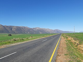
The R711 is a Regional Route in Free State, South Africa that connects Clarens with Fouriesburg.

