A Bantustan was a territory that the National Party administration of South Africa set aside for black inhabitants of South Africa and South West Africa, as a part of its policy of apartheid.
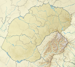
QwaQwa was a bantustan ("homeland") in the central eastern part of South Africa. It encompassed a very small region of 655 square kilometres (253 sq mi) in the east of the former South African province of Orange Free State, bordering Lesotho. Its capital was Witsieshoek. It was the designated homeland of more than 180,000 Sesotho-speaking Basotho people.

The Free State, formerly known as the Orange Free State, is a province of South Africa. Its capital is Bloemfontein, which is also South Africa's judicial capital. Its historical origins lie in the Boer republic called the Orange Free State and later the Orange Free State Province.
Tsiame Kenneth Mopeli was the former Chief Minister of the South African bantustan of QwaQwa.
Harrismith is a large town in the Free State province of South Africa. It was named for Sir Harry Smith, a 19th-century British governor and high commissioner of the Cape Colony. It is situated by the Wilge River, alongside the N3 highway, about midway between Johannesburg, about 275 km to the north-west, and Durban to the southeast. The town is located at the junction of the N5 highway, which continues westward towards the provincial capital Bloemfontein, some 340 km to the south-west. This important crossroads in South Africa's land trade routes is surrounded by mesas and buttes. It is located at the base of one of these called Platberg.

Botshabelo, meaning "a place of refuge", is a large township set up in 1979. It is located east of Bloemfontein in the present-day Free State province of South Africa. Botshabelo is now the largest township in Free State.
Charles Mopeli Stadium is located in Phuthaditjhaba, South Africa. It is mostly used by the PSL club Free State Stars and the National First Division club African Warriors. The stadium has a capacity of 35,000.Charles Mopeli Stadium also hosted one of the biggest Nedbank Cup fixture between the Soweto giants Orlando Pirates and the under dogs Maluti FET College F.C.

The Caledon River is a major river located in central South Africa. Its total length is 642 km (399 mi), rising in the Drakensberg Mountains on the Lesotho border, flowing southwestward and then westward before joining the Orange River near Bethulie in the southern Free State. The river was originally named Prinses Wilhelminas Rivier in 1777, by Colonel R J Gordon.

Dikwankwetla Party of South Africa is a political party in the Free State province, South Africa. The party was founded by Kenneth Mopeli in 1975. The party governed the bantustan state of QwaQwa from 1975 to 1994.

Golden Gate Highlands National Park is located in Free State, South Africa, near the Lesotho border. It covers an area of 340 km2 (130 sq mi). The park's most notable features are its golden, ochre, and orange-hued, deeply eroded sandstone cliffs and outcrops, especially the Brandwag rock. Another feature of the area is the numerous caves and shelters displaying San rock paintings. Wildlife featured at the park includes mongooses, eland, zebras, and over 100 bird species. It is the Free State's only national park and is more famous for the beauty of its landscape than for its wildlife. Numerous palaeontology finds have been made in the park, including dinosaur eggs and skeletons.
The QwaQwa National Park is part of the Golden Gate Highlands National Park and the Maloti-Drakensberg Park and comprises the former Bantustan (homeland) of QwaQwa. It is approximately 60 km from Harrismith on the Golden Gate Road (R712) and formed an integral part of the Highlands Treasure Route.
Maluti-a-Phofung Municipality is a local municipality within the Thabo Mofutsanyane District Municipality, in the Free State province of South Africa. It encompasses substantially all of the former bantustan of QwaQwa, except for the small enclave at Botshabelo. The population is almost entirely Basotho. The municipality is named after the Drakensberg mountains. The peak is known as the Sentinel, which is called Phofung in Sesotho.

QwaQwa Radio is a South African community radio station based in the Free State.
Tshiame is a settlement 12 km west of Harrismith in Maluti-a-Phofung Local Municipality, Thabo Mofutsanyana District Municipality in the Free State province of South Africa. It is named after Tshiame Kenneth Mopeli, Chief Minister of the defunct QwaQwa homeland.
Walter Mazinyo Matitta Phakoa was a prophet, well known amongst the Basotho in the Free State; although he was born a Hlubi. He is well known for healing people through prayer (thapelo) and one of his mysteries was being born with a full set of teeth which disappeared a few days later. His spring in Qwaqwa is still one of the most visited spaces for spiritual healing.
Witsie’s cave is a sacred site in the Free State and is named after the grandson of Chief Seeka of Makholokoe. The cave is largely associated with Makholokoe – a tribe of the Basotho and has a rich history relating to this tribe, as well as the interactions between blacks and Boers in the 1800s. The cave has been claimed by Makholokoe as an important imprint in their history and is an important landmark in the Province.
Paulus Mopeli Mokhachane (1810–1897) was an African military leader. He was half-brother to King Moshoeshoe I. He was instrumental during the wars between the Basotho and the Boers. He moved with his followers to Qwaqwa following disputes over land on the Warden line.

The Witzieshoek revolt was a rebellion of Basotho residents in Witzieshoek in the Orange Free State of South Africa during the mid 20th century. It arose as a result of South African government interventions into the traditional farming practices of the Basotho, specifically those that limited the number of stock Basotho could keep and required the culling of excess. Passive resistance to the government’s legislation had escalated in the 1940s to active disobedience, when in November 1950 a confrontation between police and Basotho farmers turned violent. Fourteen Basotho were killed, and eight others deemed to be ringleaders were later sentenced to terms of imprisonment and banishment from Witzieshoek.
The Kholokoe are a subset of the Kgatla (Bakgatla) and descend from Morena Khetsi, son of Morena Tabane. The Kholokoe people are historically found in the eastern Free State, KwaZulu-Natal, Mpumalanga, and Heidelberg. They are the descendants of Bakgatla Chief Tabane and Mathulare, daughter of the Bafokeng Chief.
Stephen Pule Phohlela is a South African politician. Formerly a politician in Qwaqwa and the founder of Thebe-e-Ntsho, he represented the African National Congress (ANC) in the National Assembly for two terms from 1994 to 2004.