The Eastern Cape is one of the nine provinces of South Africa. Its capital is Bhisho, but its two largest cities are East London and Gqeberha. Due to its climate and nineteenth century towns, it is a common location for tourists. It is also known for being home to many anti-apartheid activists, the most famous being Nelson Mandela hailing from the province.

The Free State, formerly known as the Orange Free State, is a province of South Africa. Its capital is Bloemfontein, which is also South Africa's judicial capital. Its historical origins lie in the Boer republic called the Orange Free State and later the Orange Free State Province.
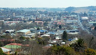
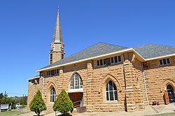
Bethlehem is a city in the eastern Free State province of South Africa that is situated on the Liebenbergs river along a fertile valley just north of the Rooiberg Mountains on the N5 road. It is the fastest growing city in the Free state province, with its target of being the third largest city after Bloemfontein and Welkom.

Clarens is a small town situated in the foothills of the Maluti Mountains in the Free State province of South Africa and nicknamed the "Jewel of the Eastern Free State". It was established in 1912 and named after the town of Clarens in Switzerland where exiled Paul Kruger spent his last days. It is situated 336 km from Johannesburg, 284 km from Bloemfontein, 389 km from Durban.

Ficksburg is a town situated at the foot of the 1,750 meter high Imperani Mountain in Free State province, South Africa. The town was founded by General Johan Fick in 1867 who won the territory in the Basotho Wars. He laid out many erven and plots that could be bought at a reasonable price. It is located on the north bank of the Mohokare River, which separates it from the town of Maputsoe in Lesotho. The town was later proclaimed a municipality in 1891. The last Governor-General of the Union of South Africa and the first State President of South Africa, Charles Robberts Swart was imprisoned here by the British in 1914 and released one day before his scheduled execution.

Petrus Steyn, is a small farming town between Tweeling and Kroonstad, 35 km north-east of Lindley in the Free State province of South Africa. It is at the centre of an agricultural area known for wheat, maize, sunflower, potato, cattle, hunting, sheep production and forms part of the breadbasket in the Free State. It is the highest town above sea level in the Free State. In 2012 the town's name was changed to Mamafubedu. Farming industries in Mamafubedu provide potatoes worldwide.
Brandfort, officially renamed Winnie Mandela in 2021, is a small agricultural town in the central Free State province of South Africa, about 60 km northeast of Bloemfontein on the R30 road. The town serves the surrounding farms for supplies and amenities. It is well known for once being home to the anti-apartheid stalwart and wife of Nelson Mandela, Winnie Mandela, during her banishment.

Pelindaba is South Africa's main nuclear research centre, run by the South African Nuclear Energy Corporation. It is situated south-east of the Hartbeespoort Dam, approximately 33 km (22 miles) west of Pretoria, on the farm that once belonged to Gustav Preller. During the apartheid era, it was the location where South Africa's atomic bombs were partially developed and constructed.

Bathurst is about 12 kilometres (7.5 mi) inland from Port Alfred, on the R67 road, in the Eastern Cape province of South Africa, and is named after Henry Bathurst, 3rd Earl Bathurst, Secretary of State for the Colonies by Sir Rufane Donkin. Its chief claim to fame is that it was the early administrative centre established by the British Government for the 1820 British Settlers who were sent to the district as a buffer between the Cape Colony and the Xhosa pastoralists who were migrating southwards and westwards along the coast. Bathurst is now part of the Ndlambe Local Municipality in the Sarah Baartman District Municipality of the Eastern Cape.

Lady Grey is a rural village in the North of the Eastern Cape in South Africa near the border with Lesotho. It is situated in the foothills of the Witteberg mountains, 54 km (34 mi) due east of Aliwal North on the R58 road and 260 km (160 mi) from the capital of the Free State Province, Bloemfontein.
The Diocese of the Free State is a diocese in the Anglican Church of Southern Africa.

The Volksblad is an Afrikaans-language daily newspaper published in Bloemfontein, South Africa, and distributed in the Free State and Northern Cape provinces, where it is the largest Afrikaans daily. It is South Africa's oldest Afrikaans The paper is owned by Media24.

Joubertina is a small town in the Kou-Kamma Local Municipality, Sarah Baartman District of the Eastern Cape province of South Africa.
Dihlabeng Municipality is a local municipality within the Thabo Mofutsanyane District Municipality, in the Free State province of South Africa. It was established after the first general local government elections on 5 December 2000, which heralded the final phase of local government reform as envisaged in 1994 at the onset of the process of democratisation and the end of apartheid. The seat is Bethlehem.
Muldersdrift, in the Gauteng Province of South Africa, is a picturesque rural area situated 27 km north-west of Johannesburg, between Johannesburg and the Magaliesberg mountain range. The area falls under the West Rand District Municipality, and is part of the Mogale City Local Municipality.
Safari Ltd is an American family-owned manufacturer and global distributor of animal figurine toys. Since 1982, they have produced painted figurines designed to educate children, with the stated goal of teaching the importance of nature and conservation through play.

Brendin 'Choppie' Horner was a 21-year-old South African farm manager for the Bloukruin Estate at Paul Roux, Free State, who was killed by a suspected stock thief or thieves. His body was recovered at DeRots farm outside Paul Roux, and two suspects were taken into custody. Horner's death heightened tensions in South Africa's ongoing farm attacks situation, and the first appearances of the two suspects at Senekal's Magistrate's Court was accompanied by protest action by political and civil rights groups, as well as far right groups that alleged Horner's murder was an example of the White genocide conspiracy theory.
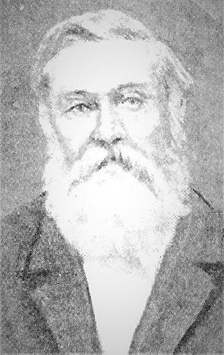
Marthinus Prinsloo was an Orange Free State Boer farmer, politician and general in the Second Boer War (1899-1902). He was born of Nicolaas Frans Prinsloo (1813-1890) and Isabella Johanna Petronella Rautenbach in the district of Graaff-Reinet, South Africa who migrated to the Orange Free State where they lived in Bloemfontein, Waterval and Bethlehem.
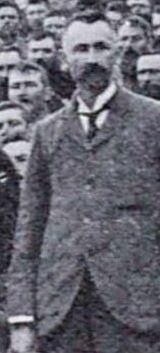
Paul Hendrik Roux was a Second Boer War general and a Protestant pastor in the Dutch Reformed Church in South Africa (NGK).

The Brandwater Basin is the drainage basin of the Brandwater River, a tributary of the Grootspruit River in the south-east of Orange Free State, South Africa, north of Lesotho. The basin is situated south of Bethlehem and south-east of Senekal, between the Witteberg to the west and north, the Rooiberge to the east, and the Drakensberg over the Caledon River to the south. It is also northwest of the Slaapkrans Basin and the Maloti Mountains on the northern border of Lesotho. Towns in the Brandwater Basin are Fouriesburg, founded in 1892, and Clarens, established in 1912.