Mahikeng, formerly, and still commonly known as Mafikeng and historically Mafeking in English, is the capital city of the North-West Province of South Africa. It was the site of the Siege of Mafeking during the Second Boer War.
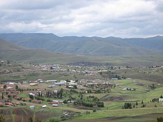
Thaba-Tseka is a district of Lesotho. Thaba-Tseka is also the name of the district's capital or camptown, which is the only town in the district. In the east, Thaba-Tseka borders on the KwaZulu-Natal Province of South Africa. Domestically, it borders on Mokhotlong District in northeast, Leribe District in north, Berea District in northwest, Maseru District in west, Mohale's Hoek District in southwest and Qacha's Nek District in the southern direction. The district is one of the major tourist attractions in Lesotho because of the second largest arch dam in Africa Katse Dam.

Lydenburg is a town in Thaba Chweu Local Municipality, Mpumalanga, South Africa. Alternatively known as Mashishing, Lydenburg is situated on the Sterkspruit/Dorps River tributary of the Lepelle River at the base of the Long Tom Pass. The name is derived from the Dutch Lijdenburg, or "Town of Suffering". Lydenburg has become the centre of the South African fly-fishing industry and is an agricultural and mining hub.

Thaba Tshwane is a military base, in Pretoria, South Africa.

Tweespruit is a small dairy farming town in the Free State province of South Africa. The town lies 27km east of Thaba Nchu and 47km north of Hobhouse.

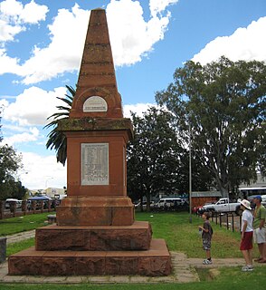
Wepener is a village in the Free State, South Africa, located near the border with Lesotho.

Lourens Jacobus (Louw) Wepener was born on 21 July 1812. He was the son of a German immigrant – Frederick Jacobus Wepener – and a Cape Colony woman – Johanna Maria Erasmus. Wepener was born in Graaf-Reinet and lived with his uncle – Lourens. He was christened by Reverend Andrew Murray of the Dutch Reformed Church. Wepener was first married to Hester Susanna Nel and then later to Hilletje Maria Levina Van Aardt. He had nine children with his second wife.

Thaba 'Nchu is a town in Free State, South Africa, 63 km east of Bloemfontein and 17 km east of Botshabelo. The population is largely made up of Tswana and Sotho people. The town was settled in the 1830s and officially established in 1873. The town grew larger following the 1913 Natives' Land Act that stated Thaba 'Nchu as a homeland for Tswana people. It was known among the Voortrekkers as Blesberg.

Motheo was, until the municipal elections of 18 May 2011, a district of the Free State province of South Africa. At the time of the 2011 elections it was disestablished as a consequence of Mangaung Local Municipality being upgraded to a metropolitan municipality

Thaba Bosiu is a sandstone plateau with an area of approximately 2 km2 and a height of 1,804 meters above sea level. It is located between the Orange and Caledon Rivers in the Maseru District of Lesotho, 24 km east of the country's capital Maseru. It was once the capital of Lesotho, having been King Moshoeshoe's stronghold.
The Diocese of the Free State is a diocese in the Anglican Church of Southern Africa.

Thaba Chweu Local Municipality, is a municipality of South Africa, located in the Ehlanzeni District Municipality, Mpumalanga.
Tseki is a town in Thabo Mofutsanyane District Municipality in the Free State province of South Africa. It is one of the oldest kasis in Qwaqwa (Phuthaditjhaba). Together with Thaba Bosiu, Bolata, Makwane, Poelong and Thaba Ntsho they were the first places where people settled when Qwaqwa was first formed by the apartheid government.

Leroro is a village in Thaba Chweu Local Municipality of Mpumalanga province, South Africa.
Matibidi is a village in Thaba Chweu Local Municipality of Mpumalanga province, South Africa.
Moremela is a village in Thaba Chweu Local Municipality of Mpumalanga province, South Africa. It is the nearest settlement to Bourke's Luck Potholes, a scenic place.
Bosoord is a village between Lydenburg and Dullstroom in Thaba Chweu Local Municipality of Mpumalanga province, South Africa.
Hendriksdal is a small village and railway stop in the forested mountains of Thaba Chweu Local Municipality of Mpumalanga province, South Africa.
Simile is the Black township on the northern side of the forestry town Sabie. It falls under the Thaba Chweu Local Municipality of Mpumalanga province, South Africa.

Regiment Louw Wepener was an infantry battalion of the South African Army. As a reserve force unit, it had a status roughly equivalent to that of a British Army Reserve or United States Army National Guard unit.


