Aberfeldy, Free State

Last updated
Aberfeldy
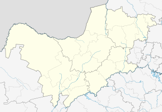
South Africa Free State location map.svg
Red pog.svg
Aberfeldy
South Africa adm location map.svg
Red pog.svg
Aberfeldy
Coordinates: 28°12′54″S28°49′30″E / 28.215°S 28.825°E / -28.215; 28.825 Coordinates: 28°12′54″S28°49′30″E / 28.215°S 28.825°E / -28.215; 28.825
Country South Africa
Province Free State
District Thabo Mofutsanyane
Municipality Maluti-a-Phofung
Time zone UTC+2 (SAST)

Aberfeldy is a small settlement located inside triangle of Phuthaditjhaba, Kestell and Harrismith surrounded by agricultural land and game farms. [1]

Phuthaditjhaba Place in Free State, South Africa

Phuthaditjhaba is a town in the Free State province of South Africa. Phuthaditjhaba is a seSotho name that means meeting place of the tribes. It is located on the banks of the Elands River. It also located in a section of Drakensberg mountains . it is bordered by the province of KwaZulu-Natal to the southeast and the independent country of Lesotho to the southwest.

Kestell Place in Free State, South Africa

Kestell is a small maize farming town in the Free State province of South Africa.

Harrismith Place in Free State, South Africa

Harrismith is a large town in the Free State province of South Africa. It was named for Sir Harry Smith, a 19th-century British governor of the Cape Colony. It is situated by the Wilge River, alongside the N3 highway, about midway between Johannesburg, about 300 km to the north-west, and Durban to the southeast. The town is located at the junction of the N5 highway, which continues westward towards the provincial capital Bloemfontein, some 340 km to the south-west. This important crossroads in South Africa's land trade routes is surrounded by mesas and buttes. It is located at the base of one of these called Platberg.

The farm Aberfeldy in the Orange Free State had a post office known as Elandsrivierbrug; when the railway reached the farm in 1902 the new Orange River Colony administration preferred "Aberfeldy", Scottish in origin, to the previous Afrikaans name. By 1905 the post office name was Anglicised into Elands River Bridge. [2]

Orange Free State independent Boer sovereign republic in southern Africa between 1854–1902

The Orange Free State was an independent Boer sovereign republic in Southern Africa during the second half of the 19th century, which ceased to exist after it was defeated and surrendered to the British Empire at the end of the Second Boer War in 1902. It is the historical precursor to the present-day Free State province. Extending between the Orange and Vaal rivers, its borders were determined by the United Kingdom of Great Britain and Ireland in 1848 when the region was proclaimed as the Orange River Sovereignty, with a British Resident based in Bloemfontein. Bloemfontein and the southern parts of the Sovereignty had previously been settled by Griqua and by Trekboere from the Cape Colony.

Orange River Colony former country

The Orange River Colony was the British colony created after Britain first occupied (1900) and then annexed (1902) the independent Orange Free State in the Second Boer War. The colony ceased to exist in 1910, when it was absorbed into the Union of South Africa as Orange Free State Province.

Related Research Articles

Newburgh, New York (town) Town in New York, United States

Newburgh is a town in Orange County, New York, United States. The 2010 census determined the population is 29,801, marking the first time ever that the population of the Town of Newburgh officially exceeded that of the adjacent but totally separate municipality known as the city of Newburgh. Estimates released by the census bureau during the middle of the first decade of the 21st century had estimated that the Town had surpassed the City in population at that time, and in fact estimated the town population as exceeding 30,000, but the release of the official census figures underscored that those estimates were inflated.

Warwick, New York Town in New York, United States

Warwick is a town in the southwest part of Orange County, New York, United States. Its population was 32,065 at the 2010 census. The town contains three villages and eight hamlets. Warwick is the home of the annual Applefest, the Summer Arts Festival, The Black Dirt Feast, the Hudson Valley Jazz Festival, and other events and festivals.

Marthinus Wessel Pretorius South African politician

Marthinus Wessel Pretorius was the first president of the South African Republic, and also compiled the constitution of the Republic.

Martinus Theunis Steyn 6th President of the Orange Free State and South African judge.

MartinusTheunis Steyn was a South African lawyer, politician, and statesman. He was the sixth and last president of the independent republic the Orange Free State from 1896 to 1902.

Vereeniging Place in Gauteng, South Africa

Vereeniging is a city in Gauteng province, South Africa, situated where the Klip River empties into the northern loop of the Vaal River. It is also one of the constituent parts of the Vaal Triangle region and was formerly situated in the Transvaal province. The name Vereeniging is derived from the Dutch word meaning "association" or "union".

Aberfeldy, Perth and Kinross town in Perth and Kinross, Scotland, UK

Aberfeldy is a burgh in Perth and Kinross, Scotland, on the River Tay. A small market town, Aberfeldy is located in Highland Perthshire and at the 2001 census had a population of about 1,895. It is also mentioned in a well-known poem by Robert Burns.

Jacobsdal Place in Free State, South Africa

Jacobsdal is a small farming town in the Free State province of South Africa with various crops under irrigation, such as grapes, potatoes, lucerne and groundnuts. The town was layout in 1859 by Christoffel Jacobs on his farm Kalkfontein, and today houses 6,500 inhabitants.

Smithfield, Free State Place in Free State, South Africa

Smithfield is a small town founded in 1848 in the Orange River Sovereignty. The town situated in a rural farming district, and is the third oldest town in present-day Free State,.

Koster, North West Place in North West, South Africa

Koster is a small farming town situated on the watershed between the Orange and Limpopo Rivers in North West Province of South Africa.

The following lists events that happened during 1903 in South Africa.

Aberfeldy, Victoria Town in Victoria, Australia

Aberfeldy is a small town in Victoria, Australia on Mount Lookout, north east of the Thomson Dam, 125 kilometres east of Melbourne.

Kirkwood, Eastern Cape Place in Eastern Cape, South Africa

Kirkwood is a town in the Eastern Cape Province of South Africa. It is situated on the banks of the Sundays River in the eponymously named Sundays River Valley, which forms part of the Sundays River Valley Municipality in the Sarah Baartman District Municipality of the Eastern Cape.

Port Williams, Nova Scotia Village in Nova Scotia, Canada

Port Williams is a Canadian village in Kings County, Nova Scotia. It is located on the north bank of the Cornwallis River. The village is named in honour of Sir William Fenwick Williams, who fought in the Siege of Kars. Williams became the first post Canadian Confederation Lieutenant Governor of Nova Scotia. As of 2016, the population was 1,120.

Africa is an unincorporated community located in Orange Township of southern Delaware County, Ohio, United States, by Alum Creek.

Onseepkans Place in Northern Cape, South Africa

Onseepkans is a small settlement on the banks of the Orange River in Northern Cape Province, South Africa. It is a border post with Namibia for traffic between Pofadder in South Africa and Keetmanshoop in Namibia. The name either originated from a combination of three Nama words: ‘tconsiep’, ‘nias’, and ‘tcaans’ (thorntrees), or a derivative of a nama word that means 'watering place for cattle'.

River, Kentucky Unincorporated community in Kentucky, United States

River is an unincorporated community in Johnson County, Kentucky, United States. The post office was first established on September 6, 1890, and its current ZIP code is 41254. Its telephone area code is 606. Its geographic coordinates are.

Aberfeldy River river in Australia

The Aberfeldy River is a perennial river of the West Gippsland catchment, located in the Alpine region of the Australian state of Victoria.

References

  1. "Towns included in the". Grasslands Meander. Archived from the original on 2013-07-23. Retrieved 29 August 2014.
  2. African Research & Documentation. African Studies Association of the UK. 2000. p. 51.