
Hydrographic survey is the science of measurement and description of features which affect maritime navigation, marine construction, dredging, offshore oil exploration/offshore oil drilling and related activities. Strong emphasis is placed on soundings, shorelines, tides, currents, seabed and submerged obstructions that relate to the previously mentioned activities. The term hydrography is used synonymously to describe maritime cartography, which in the final stages of the hydrographic process uses the raw data collected through hydrographic survey into information usable by the end user.

A survey vessel is any type of ship or boat that is used for underwater surveys, usually to collect data for mapping or planning underwater construction or mineral extraction. It is a type of research vessel, and may be designed for the purpose, modified for the purpose or temporarily put into the service as a vessel of opportunity, and may be crewed, remotely operated, or autonomous. The size and equipment vary to suit the task and availability.

A research vessel is a ship or boat designed, modified, or equipped to carry out research at sea. Research vessels carry out a number of roles. Some of these roles can be combined into a single vessel but others require a dedicated vessel. Due to the demanding nature of the work, research vessels may be constructed around an icebreaker hull, allowing them to operate in polar waters.

The National Oceanic and Atmospheric Administration (NOAA) operates a wide variety of specialized ships and aircraft to carry out NOAA's environmental and scientific missions.

NOAAS Rude was an American Rude-class hydrographic survey ship that was in commission in the National Oceanic and Atmospheric Administration (NOAA) from 1970 to 2008. Prior to its NOAA career, it was in commission in the United States Coast and Geodetic Survey from 1967 to 1970 as USC&GS Rude. It was named for Gilbert T. Rude, former Chief of the Division of Coastal Surveys of the Coast and Geodetic Survey.

NOAA Ship Rainier is a survey vessel in commission with the National Oceanic and Atmospheric Administration (NOAA). Her primary mission is to chart all aspects of the ocean and sea floor, primarily in Alaska and the Pacific Northwest. The ship is home-ported at the NOAA Marine Operations Center - Pacific in Newport, Oregon.

USNS Titan (T-AGOS-15) was a Stalwart-class modified tactical auxiliary general ocean surveillance ship in service in the United States Navy from 1989 to 1993. From 1996 to 2014, she was in commission in the National Oceanic and Atmospheric Administration (NOAA) fleet as the oceanographic research ship NOAAS Ka'imimoana.

NOAAS Thomas Jefferson is a National Oceanic and Atmospheric Administration (NOAA) hydrographic survey vessel in service since 2003. The ship was built for the United States Navy as USNS Littlehales (T-AGS-52) serving as one of two new coastal hydrographic survey vessels from 1992 until transfer to NOAA in 2003 when it was named after Founding Father and third U.S. president, Thomas Jefferson.
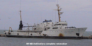
NOAAS Mount Mitchell was an American survey vessel in commission in the National Oceanic and Atmospheric Administration from 1970 to 1995. Prior to her NOAA career, she was in commission in the United States Coast and Geodetic Survey as USC&GS Mount Mitchell from 1968 to 1970. In 2003, she returned to service as the private research ship R/V Mt. Mitchell.

NOAAS Davidson was a survey ship in commission in the National Oceanic and Atmospheric Administration (NOAA) from 1970 to 1989. Prior to her NOAA service, she was in commission in the United States Coast and Geodetic Survey from 1967 to 1970 as USC&GS Davidson, the second Coast and Geodetic Survey ship of the name. She was the only sister ship of NOAAS McArthur (S 330).
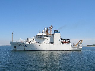
NOAAS Henry B. Bigelow is a fisheries research vessel operated by the United States' National Oceanic Atmospheric Administration (NOAA). She is the second in a class of five new fisheries research vessels. She is named after Henry Bryant Bigelow (1879-1967), the American oceanographer, zoologist, and marine biologist who founded the Woods Hole Oceanographic Institution in Woods Hole, Massachusetts.

NOAAS Reuben Lasker is a National Oceanic and Atmospheric Administration (NOAA) fishery research vessel. The ship's namesake, Reuben Lasker, was a fisheries biologist who served with the Southwest Fisheries Center, National Marine Fisheries Service, and taught at the Scripps Institution of Oceanography. This class of NOAA ships is very similar to, and based in part upon, the Neil Armstrong-class Oceanographic Research (AGOR) ships owned by the Office of Naval Research and operated by various US Universities.

NOAAS Ferdinand R. Hassler is a coastal mapping vessel for the National Oceanic and Atmospheric Administration. Commissioned on 8 June 2012, Ferdinand R. Hassler is one of the newest additions to the NOAA hydrographic charting fleet. Operating from the Great Lakes to the Gulf of Mexico, the ship's primary mission is hydrographic survey in support of NOAA's nautical charting mission. The ship's home port is New Castle, New Hampshire.

NOAAS Whiting, was an American survey ship that was in commission in the National Oceanic and Atmospheric Administration (NOAA) from 1970 to 2003. Previously, she had been in commission in the United States Coast and Geodetic Survey from 1963 to 1970 as USC&GS Whiting.

NOAAS Ferrel was an American hydrographic survey ship that was in commission in the National Oceanic and Atmospheric Administration (NOAA) from 1970 to 2002. Prior to her NOAA career, she was in commission in the United States Coast and Geodetic Survey from 1968 to 1970 as USC&GS Ferrel.
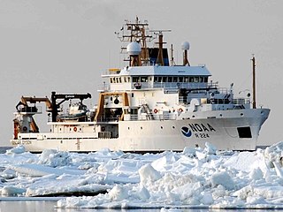
NOAAS Oscar Dyson is an American fisheries and oceanographic research vessel in commission in the National Oceanic and Atmospheric Administration (NOAA) fleet since 2005.

NOAAS Pisces is an American fisheries and oceanographic research vessel in commission in the National Oceanic and Atmospheric Administration (NOAA) fleet since 2009.
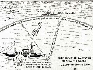
Radio acoustic ranging, occasionally written as "radio-acoustic ranging" and sometimes abbreviated RAR, was a method for determining a ship's precise location at sea by detonating an explosive charge underwater near the ship, detecting the arrival of the underwater sound waves at remote locations, and radioing the time of arrival of the sound waves at the remote stations to the ship, allowing the ship's crew to use true range multilateration to determine the ship's position. Developed by the United States Coast and Geodetic Survey in 1923 and 1924 for use in accurately fixing the position of survey ships during hydrographic survey operations, it was the first navigation technique in human history other than dead reckoning that did not require visual observation of a landmark, marker, light, or celestial body, and the first non-visual means to provide precise positions. First employed operationally in 1924, radio acoustic ranging remained in use until 1944, when new radio navigation techniques developed during World War II rendered it obsolete.

USFS Pelican was an American fisheries science research ship and fishery patrol vessel that operated along the United States East Coast and the United States Gulf Coast and in the waters of the Territory of Alaska. She was part of the United States Bureau of Fisheries (BOF) fleet from 1930 to 1940. She then served as US FWS Pelican in the fleet of the Fish and Wildlife Service – from 1956 the United States Fish and Wildlife Service – from 1940 to 1958. She served as a fishery patrol vessel while on loan to the Washington Department of Fish and Wildlife from 1958 to 1970, then briefly returned to the Fish and Wildlife Service's successor agency, the National Marine Fisheries Service. Her United States Government service ended when she was sold into private hands in 1972, and she remained extant as of 2010. In 2017 Captain Patrick Burns and Captain John (Johnny) Sylvester purchased the Pelican from Marilyn Masland. She is currently moored in Deer Harbor on Orcas Island, WA. In 2018 she was brought up the Inside Passage to Alaska and back to Washington.

Richard Thomas Brennan, Jr. (1968–2021) was a rear admiral in the NOAA Commissioned Officer Corps where he served as the 31st director of the Office of Coast Survey, replacing Shepard Smith. He also commanded NOAA Ship Rainier and NOAA Ship Rude.

