
The United States Army Corps of Engineers (USACE) is an engineer formation of the United States Army that has three primary mission areas: Engineer Regiment, military construction, and civil works. The day-to-day activities of the three mission areas are administered by a lieutenant general known as the commanding general/chief of engineers. The chief of engineers commands the Engineer Regiment, comprising combat engineer, rescue, construction, dive, and other specialty units, and answers directly to the Chief of Staff of the Army. Combat engineers, sometimes called sappers, form an integral part of the Army's combined arms team and are found in all Army service components: Regular Army, National Guard, and Army Reserve. Their duties are to breach obstacles; construct fighting positions, fixed/floating bridges, and obstacles and defensive positions; place and detonate explosives; conduct route clearance operations; emplace and detect landmines; and fight as provisional infantry when required. For the military construction mission, the commanding general is directed and supervised by the Assistant Secretary of the Army for installations, environment, and energy, whom the President appoints and the Senate confirms. Military construction relates to construction on military bases and worldwide installations.

Beaver Lake is a man-made reservoir in the Ozark Mountains of Northwest Arkansas and is formed by a dam across the White River. Beaver Lake has some 487 miles (784 km) of shoreline. With towering limestone bluffs, natural caves, and a wide variety of trees and flowering shrubs, it is a popular tourist destination. Beaver Lake is the source of drinking water in Northwest Arkansas, which is managed, treated and sold by Beaver Water District, serving more than 450,000 customers. One out of 7 people in Arkansas get their drinking water from Beaver Lake.

Lake Strom Thurmond, officially designated J. Strom Thurmond Reservoir at the federal level, and Clarks Hill Lake by the state of Georgia, is a man-made reservoir at the border between Georgia and South Carolina in the Savannah River Basin.

B. Everett Jordan Lake is a reservoir in New Hope Valley, west of Cary and south of Durham in Chatham County, North Carolina, in the United States; the northernmost end of the lake extends into southwestern Durham County.

Lake Oahe is a large reservoir behind Oahe Dam on the Missouri River; it begins in central South Dakota and continues north into North Dakota in the United States. The lake has an area of 370,000 acres (1,500 km2) and a maximum depth of 205 ft (62 m). By volume, it is the fourth-largest reservoir in the US. Lake Oahe has a length of approximately 231 mi (372 km) and has a shoreline of 2,250 mi (3,620 km). 51 recreation areas are located along Lake Oahe, and 1.5 million people visit the reservoir every year. The lake is named for the 1874 Oahe Indian Mission.

Lake Allatoona is a U.S. Army Corps of Engineers reservoir on the Etowah River in northwestern part of the State of Georgia. This reservoir is mostly in southeastern Bartow County and southwestern Cherokee County. A small portion is located in Cobb County near Acworth.

Jennings Randolph Lake is a reservoir of 952 acres (3.85 km2) located on the North Branch Potomac River in Garrett County, Maryland and Mineral County, West Virginia. It is approximately 8 miles (13 km) upstream of Bloomington, Maryland, and approximately 5 miles (8.0 km) north of Elk Garden, West Virginia.

Lewis and Clark Lake is a 31,400 acre (130 km²) reservoir located on the border of the U.S. states of Nebraska and South Dakota on the Missouri River. The lake is approximately 25 miles (40 km) in length with over 90 miles (140 km) of shoreline and a maximum water depth of 45 feet (14 m). The lake is impounded by Gavins Point Dam and is managed by the U.S. Army Corps of Engineers, Omaha District.

DeGray Lake is a reservoir on the Caddo River constructed by the United States Army Corps of Engineers in Arkansas, 8 miles (13 km) from Arkadelphia. Arkansas Scenic Byway 7 is located on the eastern shore of the lake, and provides views of the lake, and also places to stay. DeGray Lake Resort State Park was opened in 1974 to encourage tourism and recreation on DeGray Lake.

Hartwell Dam is a concrete and embankment dam located on the Savannah River at the border of South Carolina and Georgia, creating Lake Hartwell. The dam was built by the U.S. Army Corps of Engineers between 1955 and 1962 for the purposes of flood control, hydropower and navigation. The concrete and earthen structure spans 15,840 feet (4,828 m). The concrete section is 1,900 feet (579 m) long and rises 204 feet (62 m) above the riverbed at its apex. The Hartwell Dam currently produces 468 million KWh of electricity annually, has prevented over $40 million in flood damage since completion and also provides recreation, water quality, water supply, along with fish and wildlife management.
Pine Flat Lake is an artificial lake or reservoir in the Sierra Nevada foothills of eastern Fresno County, California on the western north-south border to the Sierra- and Sequoia National Forests, about 30 mi (48 km) east of Fresno. The lake is managed by the U.S. Army Corps of Engineers (USACE) and is open to boaters, campers & hikers.

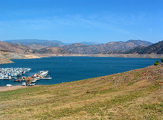
Isabella Dam is an embankment dam located in the Kern River Valley, about halfway down the Kern River course, between the towns of Kernville and Lake Isabella in Kern County, California.

The San Pablo Reservoir is an open cut terminal water storage reservoir owned and operated by the East Bay Municipal Utility District (EBMUD). It is located in the valley of San Pablo Creek, north of Orinda, California, United States, and south of El Sobrante and Richmond, east of the Berkeley Hills between San Pablo Ridge and Sobrante Ridge.

Englebright Lake is an 815 acre reservoir on the Yuba River, impounded by Englebright Dam, in the Sierra Nevada, Northern California, United States. The reservoir stores 45,000 acre feet of water with nearly 24 miles of shoreline.

J. Strom Thurmond Dam, also known in Georgia as Clarks Hill Dam, is a concrete-gravity and embankment dam located 22 miles (35 km) north of Augusta, Georgia on the Savannah River at the border of South Carolina and Georgia, creating Lake Strom Thurmond. U.S. Route 221 cross it. The dam was built by the U.S. Army Corps of Engineers between 1946 and 1954 for the purposes of flood control, hydroelectricity and downstream navigation. The concrete structure of the dam spans 1,096 feet (334 m) and rises 204 feet (62 m) above the riverbed, housing a power plant with an installed 380 MW capacity. The Dam has prevented over $3.1 million in estimated flood damage annually and also provides recreation, water quality, water supply, along with fish and wildlife management.

Calero Reservoir, also called Calero Lake, is a reservoir in San Jose, California, located in the Calero neighborhood of Almaden Valley in South San Jose. It is the site of Calero County Park, which also includes a large area covering the lake and hundreds of acres of hills around it.

North Hartland Dam is a dam on the Ottauquechee River in Hartland, Windsor County, Vermont.

West Point Lake is a man-made reservoir located mostly in west-central Georgia on the Chattahoochee River and maintained by the U.S. Army Corps of Engineers (USACE). The Chattahoochee river flows in from the north, before flowing through the West Point Dam, which impounds the lake, and continuing to Columbus, Georgia. Of the four major USACE lakes in the ACF River Basin, West Point Lake is the smallest by area containing 25,864 acres (10,467 ha) of water, and has the second shortest shoreline at 604 mi (972 km). The purposes of the reservoir are to provide flood control, hydroelectric power, and water storage to aid the navigation of the lower Chattahoochee.

