
The Great Serpent Mound is a 1,348-foot-long (411 m), three-foot-high prehistoric effigy mound located in Peebles, Ohio. It was built on what is known as the Serpent Mound crater plateau, running along the Ohio Brush Creek in Adams County, Ohio. The mound is the largest serpent effigy in the world.

The Adena culture was a Pre-Columbian Native American culture that existed from 500 BCE to 100 CE, in a time known as the Early Woodland period. The Adena culture refers to what were probably a number of related Native American societies sharing a burial complex and ceremonial system. The Adena culture was centered on the location of the modern state of Ohio, but also extended into contiguous areas of northern Kentucky, eastern Indiana, West Virginia, and parts of extreme western Pennsylvania.

The Grave Creek Mound in the Ohio River Valley in West Virginia is one of the largest conical-type burial mounds in the United States, now standing 62 feet (19 m) high and 240 feet (73 m) in diameter. The builders of the site, members of the Adena culture, moved more than 60,000 tons of dirt to create it about 250–150 BC.

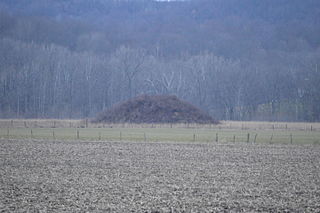
The Great Mound is a massive Native American mound in the southwestern part of the U.S. state of Ohio. Located in Section 19 of Madison Township in Butler County, it has a height of 43 feet (13 m) and a circumference of 511 feet (156 m). Its total volume is nearly 825,000 cubic feet (23,400 m3), making it the largest mound in Butler County and one of the largest in southwestern Ohio. Because of the mound's height and its placement on a ridgeline, an individual at the summit can see for a great distance. In the late nineteenth century, it was theorized that mounds such as the Great Mound were built as observation or watch points, and that the builders maintained the ability to light fires atop the mounds as a method of communicating across wide distances. The potential of these mounds for long-distance communication was demonstrated in 1990 by three groups of volunteers. After climbing the Great Mound, the first group established visual contact with the Hill-Kinder Mound in Franklin, from which point the observers of the second group contacted the third group atop the Miamisburg Mound near Dayton.

The Arledge Mounds are a pair of Native American mounds in the south central part of the U.S. state of Ohio. Located near Circleville in Pickaway County, the two mounds lie in the middle of a farm field, far from any roads. These two mounds are disparate in size: while the smaller mound's height is 5 feet (1.5 m), the other's is 20 feet (6.1 m), and their diameters are approximately 65 feet (20 m) and 120 feet (37 m) respectively.

The Kincaid Mounds Historic Site c. 1050–1400 CE, is a Mississippian culture archaeological site located at the southern tip of present-day U.S. state of Illinois, along the Ohio River. Kincaid Mounds has been notable for both its significant role in native North American prehistory and for the central role the site has played in the development of modern archaeological techniques. The site had at least 11 substructure platform mounds, and 8 other monuments.
The Reeves Mound is a Native American mound in the southeastern part of the U.S. state of Ohio. Located north of the unincorporated community of Alfred, the mound is part of an archaeological site that appears to have been built by peoples of the Adena culture.

The Carl Potter Mound is a historic Native American mound in southern Champaign County, Ohio, United States. Located near Mechanicsburg, it lies on a small ridge in a pasture field in southeastern Union Township. In 1974, the mound was listed on the National Register of Historic Places as a potential archaeological site, primarily because of its use as a burial mound.
The David Stitt Mound is a Native American mound near Chillicothe in Ross County, Ohio, United States. Located on elevated land at a significant distance from the Scioto River, the mound is built in a sub-conical shape; it is 19.4 feet (5.9 m) high and has a diameter of approximately 130 feet (40 m).
The Zaleski Mound Group is a collection of three burial mounds in the village of Zaleski, Ohio, United States. Built by people of the prehistoric Adena culture, these earthworks are valuable archaeological sites.

The W.C. Clemmons Mound is a Native American mound in the south central portion of the U.S. state of Ohio. Located near the unincorporated community of Fox, it lies in the middle of a farm field near a creek. A cone measuring approximately 22 feet (6.7 m) high and 144 feet (44 m) in diameter, its shape is almost exactly circular.
The Theodore B. Schaer Mound is a Native American mound in the central part of the U.S. state of Ohio. Located southeast of the city of Canal Winchester in Fairfield County, it is a large mound; its height is 13 feet (4.0 m), and it is 60 feet (18 m) in diameter. Today, the mound sits in woodland, being covered with brush and trees. Since white settlement of the region, the mound has seen few changes: individuals hunting for Indian relics have damaged it slightly, but the most significant effects have been minor natural phenomena such as the diggings of groundhogs.
The Old Maid's Orchard Mound is a Native American mound in the central portion of the U.S. state of Ohio. Located near the village of Lithopolis in Fairfield County, the mound lies within the boundaries of Chestnut Ridge Metro Park, in northern Bloom Township.
The Edith Ross Mound is a Native American mound and archaeological site in the southeastern part of the U.S. state of Ohio. Located near the village of Laurelville in Hocking County, the mound is a circular structure that measures 40 feet (12 m) in diameter at its base and 4.6 feet (1.4 m) high at the center. It is constructed primarily of earth, with large stones placed on various parts of the surface. Few changes have been made to the mound since white settlement of the region; a small depression in the northwestern corner may be the result of someone digging, but no significant damage was done.
The Karshner Mound is a Native American mound in the southeastern portion of the U.S. state of Ohio. Located near the village of Laurelville in Hocking County, it is one of Ohio's largest remaining burial mounds that has not been significantly damaged since white settlement. Measuring 100 feet (30 m) in diameter and 28 feet (8.5 m) high, it lies in the middle of a farm field, but it has never been cultivated, and vegetation on the mound has prevented erosion.

The Jackson Mound is a Native American mound in the south-central portion of the U.S. state of Ohio. Located north of Pancoastburg in Fayette County, it measures approximately 75 feet (23 m) in diameter and 5.5 feet (1.7 m) in height. The mound has never been excavated, making the certain identification of its builders impossible; however, its location on a high terrace above a relatively small stream suggests that it was built by the Adena culture, which favored such sites for its many mounds. If true, it was originally more conical in shape, and it is likely to cover the remains of a wooden charnel house built by the Adena.

The Hillside Haven Mound is a Native American mound in the southwestern part of the U.S. state of Ohio. Located southwest of Oakland in Clinton County, it sits in dense woodland on the side of a hill. It is believed to have been conical in shape at the time of construction, but today it is rounded in shape, measuring 2.5 feet (0.76 m) high and 33 feet (10 m) in diameter.
The Beam Farm Woodland Archaeological District is a group of archaeological sites in the southwestern part of the U.S. state of Ohio. Located at 3983 Stone Road near the village of Sabina in Clinton County, the district is composed of one Native American mound and two other archaeological sites spread out over an area of 2 acres (0.81 ha). Known as the Beam Farm Mound and the Beam Sites 9 and 12, the sites that compose the district have yielded artifacts from the Adena culture and the Hopewell tradition, both of which inhabited southwestern Ohio during the Woodland period. Because both the Adena and the Hopewell lived around the mound, and because both cultures built mounds, the identity of the people who constructed the Beam Farm Mound cannot be established; all that can be known with reasonable certainty is that it was raised during the early or middle portion of the Woodland period, or between 800 BC and AD 500.

The McLaughlin Mound, also called Cemetery Mound, is a Native American mound in the central part of the U.S. state of Ohio. Located in Mound View Cemetery near the city of Mount Vernon in Knox County, it is an important archaeological site.

The Raleigh Mound (33KN32) is a Native American mound in the village of Fredericktown, Ohio, United States. Built thousands of years ago, the mound is an important archaeological site.


