
Zaleski is a village in Vinton County, Ohio, United States. The population was 278 at the 2010 census.

The Grave Creek Mound in the Ohio River Valley in West Virginia is one of the largest conical-type burial mounds in the United States, now standing 62 feet (19 m) high and 240 feet (73 m) in diameter. The builders of the site, members of the Adena culture, moved more than 60,000 tons of dirt to create it about 250–150 BC.
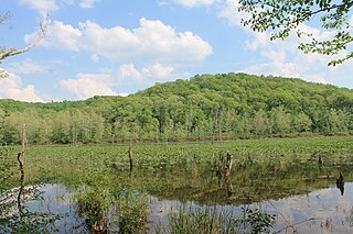
Zaleski State Forest is a state forest in the U.S. state of Ohio, located primarily in Vinton County, with areas in Athens County as well. The 28,000 acre (110 km²) forest surrounds Lake Hope State Park in Vinton County, and borders the Waterloo Wildlife Research Station in Athens County.

The Mathew Mound is a Native American mound in the southwestern part of the U.S. state of Ohio. Located off Oak Road near the village of Evendale, the mound is believed to have been built by members of the Adena or Hopewell peoples during the Woodland period.

The Story Mound is a Native American mound in the southwestern part of the U.S. state of Ohio. Located in the Sayler Park neighborhood of the city of Cincinnati, the mound lies along Gracely Drive. No archaeological excavation has ever been conducted at the mound, and it has remained otherwise undisturbed as well; consequently, the mound remains in pristine condition. Despite the lack of evidence from excavations, the mound has been determined to be a work of the Adena culture, due in part to artifacts such as bones that have been found in the land immediately surrounding the mound. These findings, together with the mound's location near the floodplain of the Ohio River, have been understood as evidence of a larger group of Adena sites in the vicinity of the Story Mound. Such a complex, if it exists, would have great value as an archaeological site; therefore, the Story Mound was listed on the National Register of Historic Places in 1975.

The Arledge Mounds are a pair of Native American mounds in the south central part of the U.S. state of Ohio. Located near Circleville in Pickaway County, the two mounds lie in the middle of a farm field, far from any roads. These two mounds are disparate in size: while the smaller mound's height is 5 feet (1.5 m), the other's is 20 feet (6.1 m), and their diameters are approximately 65 feet (20 m) and 120 feet (37 m) respectively.
The David Stitt Mound is a Native American mound near Chillicothe in Ross County, Ohio, United States. Located on elevated land at a significant distance from the Scioto River, the mound is built in a sub-conical shape; it is 19.4 feet (5.9 m) high and has a diameter of approximately 130 feet (40 m).

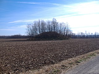
The Ratcliffe Mound (33-Vi-3) is a Native American mound in the southeastern part of the U.S. state of Ohio. Located in western Vinton County, it lies to the east of the community of Londonderry, at the bottom of a steep-walled valley. Sitting in the middle of farm fields near a stream, the mound is isolated in open countryside; there are no nearby woodlots. The mound is a circular cone in shape, 14 feet (4.3 m) high and 86 feet (26 m) in diameter.
The Austin Brown Mound, also known as the "Dwight Fullerton Mound," is a subconical Native American mound located northwest of the city of Chillicothe in Ross County, Ohio, United States. In 1897, the Ohio Historical Society sponsored an excavation of the mound under the leadership of Clarence Loveberry, who oversaw the digging of a large tunnel into the mound's side. Loveberry's investigation yielded artifacts of the Adena culture and evidence of rotten logs on the floor of the mound, but in publishing the results of his excavation, he observed that neither a tomb nor any isolated burials were discovered within the mound. Since 1897, other Adena mounds have been excavated and shown to have wooden tombs in off-center locations, presumably to complicate the efforts of those who would loot the mounds; accordingly, it is possible that the Brown mound likewise has an off-center tomb.
The Snead Mound is a Native American mound in the southwestern portion of the U.S. state of Ohio. Located off U.S. Route 52 near the community of Neville, it lies in woodland atop a bluff. The mound is a conical structure measures approximately 5 feet (1.5 m) high and 55 feet (17 m) in diameter at the base; except for a small hole that may have been dug by a hunter, the mound appears never to have been disturbed since white settlement of the region.
The Theodore B. Schaer Mound is a Native American mound in the central part of the U.S. state of Ohio. Located southeast of the city of Canal Winchester in Fairfield County, it is a large mound; its height is 13 feet (4.0 m), and it is 60 feet (18 m) in diameter. Today, the mound sits in woodland, being covered with brush and trees. Since white settlement of the region, the mound has seen few changes: individuals hunting for Indian relics have damaged it slightly, but the most significant effects have been minor natural phenomena such as the diggings of groundhogs.
The Old Maid's Orchard Mound is a Native American mound in the central portion of the U.S. state of Ohio. Located near the village of Lithopolis in Fairfield County, the mound lies within the boundaries of Chestnut Ridge Metro Park, in northern Bloom Township.

The Coon Hunters Mound is a Native American mound in the central part of the U.S. state of Ohio. Located near the village of Carroll, it sits on the grounds of the Central Ohio Coonhunters Association.
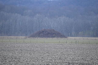
The Karshner Mound is a Native American mound in the southeastern portion of the U.S. state of Ohio. Located near the village of Laurelville in Hocking County, it is one of Ohio's largest remaining burial mounds that has not been significantly damaged since white settlement. Measuring 100 feet (30 m) in diameter and 28 feet (8.5 m) high, it lies in the middle of a farm field, but it has never been cultivated, and vegetation on the mound has prevented erosion.

The Hillside Haven Mound is a Native American mound in the southwestern part of the U.S. state of Ohio. Located southwest of Oakland in Clinton County, it sits in dense woodland on the side of a hill. It is believed to have been conical in shape at the time of construction, but today it is rounded in shape, measuring 2.5 feet (0.76 m) high and 33 feet (10 m) in diameter.

The Hodgen's Cemetery Mound is a Native American mound in the far eastern part of the U.S. state of Ohio. Located in the village of Tiltonsville along the Ohio River shoreline of Jefferson County, the mound is a prehistoric earthwork and archaeological site, and it has been named a historic site.

The Wright-Patterson Air Force Base Mound, designated 33GR31, is a Native American mound near the city of Dayton in Greene County, Ohio, United States. Named for its location on an Air Force facility, Wright-Patterson Air Force Base, the mound is an archaeological site.

The Raleigh Mound (33KN32) is a Native American mound in the village of Fredericktown, Ohio, United States. Built thousands of years ago, the mound is an important archaeological site.
The Coe Mound is a Native American burial mound in Columbus, Ohio. The mound was created around 2,000 years ago by the Pre-Columbian Native American Adena or Hopewell culture. The site was added to the National Register of Historic Places in 1974.


