Zaleski, Ohio

Last updated

Zaleski, Ohio
Ranger Station Mound, southern side.jpg
The Ranger Station Mound, part of the Zaleski Mound Group
Vinton County Ohio incorporated and unincorporated areas Zaleski highlighted.svg
Location in Vinton County and the state of Ohio.
Detailed map of Zaleski.png
Detailed map of Zaleski
Coordinates: 39°16′55″N82°23′40″W / 39.28194°N 82.39444°W / 39.28194; -82.39444
Country United States
State Ohio
County Vinton
Township Madison
Area
[1]
  Total0.41 sq mi (1.07 km2)
  Land0.40 sq mi (1.05 km2)
  Water0.01 sq mi (0.02 km2)
Elevation
[2]
745 ft (227 m)
Population
 (2020)
  Total230
  Density569.31/sq mi (219.86/km2)
Time zone UTC-5 (Eastern (EST))
  Summer (DST) UTC-4 (EDT)
ZIP code
45698
Area code 740
FIPS code 39-88028
GNIS feature ID2399755 [2]

Zaleski is a village in Vinton County, Ohio, United States. The population was 230 at the 2020 census.

Contents

History

Six Native American mounds, built by the prehistoric Adena culture, were once located at Zaleski. Three have been destroyed, [3] but the others — known as the Markham, Ranger Station and Zaleski Methodist Church Mounds — are still in existence. Together these three compose the Zaleski Mound Group. [4]

Zaleski was laid out in 1856 as a mining community. [5] The village was named for Peter. F. Zaleski, a Polish-American official with the mining company that originally owned the town site. [6] Zaleski once had an iron blast furnace. [7]

Beginning in February 2014, Zaleski began construction on a public sewer plant project, making it only the third village in the county (after, McArthur and Hamden) to have a public waste facility. [8]

Geography

According to the United States Census Bureau, the village has a total area of 0.45 square miles (1.17 km2), of which 0.44 square miles (1.14 km2) is land and 0.01 square miles (0.03 km2) is water. [9]

Zaleski is located on Raccoon Creek, a tributary of the Ohio River. [10]

Demographics

Historical population
CensusPop.Note
1870 690
1880 1,17570.3%
1890 802−31.7%
1900 577−28.1%
1910 476−17.5%
1920 395−17.0%
1930 367−7.1%
1940 3741.9%
1950 3883.7%
1960 336−13.4%
1970 304−9.5%
1980 34714.1%
1990 294−15.3%
2000 37527.6%
2010 278−25.9%
2020 230−17.3%
U.S. Decennial Census [11]

2010 census

At the 2010 census, [12] there were 278 people, 123 households and 80 families living in the village. The population density was 631.8 inhabitants per square mile (243.9/km2). There were 148 housing units at an average density of 336.4 per square mile (129.9/km2). The racial makeup of the village was 98.2% White, 0.4% from other races, and 1.4% from two or more races.

There were 123 households, of which 26.0% had children under the age of 18 living with them, 45.5% were married couples living together, 10.6% had a female householder with no husband present, 8.9% had a male householder with no wife present, and 35.0% were non-families. 33.3% of all households were made up of individuals, and 13.8% had someone living alone who was 65 years of age or older. The average household size was 2.26 and the average family size was 2.81.

The median age was 43 years. 19.4% of residents were under the age of 18; 8.7% were between the ages of 18 and 24; 24.5% were from 25 to 44; 32% were from 45 to 64; and 15.5% were 65 years of age or older. The gender makeup of the village was 50.0% male and 50.0% female.

2000 census

At the 2000 census, [13] there were 375 people, 148 households and 111 families living in the village. The population density was 786.3 inhabitants per square mile (303.6/km2). There were 169 housing units at an average density of 354.4 per square mile (136.8/km2). The racial makeup of the village was 98.13% White, 0.53% African American, 1.07% Native American, and 0.27% from two or more races.

There were 148 households, of which 31.8% had children under the age of 18 living with them, 55.4% were married couples living together, 12.2% had a female householder with no husband present, and 25.0% were non-families. 22.3% of all households were made up of individuals, and 11.5% had someone living alone who was 65 years of age or older. The average household size was 2.53 and the average family size was 2.86.

22.7% of the population were under the age of 18, 8.3% from 18 to 24, 32.3% from 25 to 44, 24.8% from 45 to 64, and 12.0% who were 65 years of age or older. The median age was 37 years. For every 100 females, there were 95.3 males. For every 100 females age 18 and over, there were 88.3 males.

The median household income was $29,500 and the median family income was $33,750. Males had a median income of $27,500 compared with $22,083 for females. The per capita income for the village was $13,443. About 9.9% of families and 16.7% of the population were below the poverty line, including 10.8% of those under age 18 and 28.1% of those age 65 or over.

Related Research Articles

<span class="mw-page-title-main">Aberdeen, Ohio</span> Village in Ohio, United States

Aberdeen is a village in Huntington Township, Brown County, Ohio, United States, along the Ohio River 50 miles (80 km) southeast of Cincinnati. The population was 1,515 at the 2020 census.

<span class="mw-page-title-main">Enon, Ohio</span> Village in Ohio, United States

Enon is a village in Clark County, Ohio, United States. The population was 2,455 at the 2020 census. It is part of the Springfield, Ohio Metropolitan Statistical Area.

<span class="mw-page-title-main">Warsaw, Ohio</span> Village in Ohio, United States

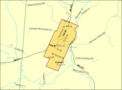
Warsaw is a village in Coshocton County, Ohio, United States, along the Walhonding River. The population was 624 at the 2020 census.

<span class="mw-page-title-main">Gordon, Ohio</span> Village in Ohio, United States

Gordon is a village in Darke County, Ohio, United States. The population was 245 at the 2020 census.

<span class="mw-page-title-main">Ithaca, Ohio</span> Village in Ohio, United States

Ithaca is a village in Darke County, Ohio, United States. The population was 81 at the 2020 census.

<span class="mw-page-title-main">Brice, Ohio</span> Village in Ohio, United States

Brice is a village in Franklin County, Ohio, United States, on the southeast side of the Columbus metropolitan area. The population was 93 at the 2020 census.

<span class="mw-page-title-main">Addyston, Ohio</span> Village in Ohio, United States

Addyston is a village in Miami Township, Hamilton County, Ohio, United States. Located along the Ohio River, it is a western suburb of the neighboring city of Cincinnati. The population was 927 at the 2020 census.

<span class="mw-page-title-main">Cleves, Ohio</span> City in Ohio, United States

Cleves is a village in Miami Township, Hamilton County, Ohio, United States. Located along the Ohio River, it is a western suburb of Cincinnati. The population was 3,414 at the 2020 census.

<span class="mw-page-title-main">Newtown, Ohio</span> Village in Ohio, United States

Newtown is a village in southeastern Hamilton County, Ohio, United States, near Cincinnati. The population was 2,702 at the 2020 census. Newtown was settled in 1792 and incorporated as a village in 1901.

<span class="mw-page-title-main">North Bend, Ohio</span> Village in Ohio, United States

North Bend is a village in Miami Township, Hamilton County, Ohio, United States, along the Ohio River. It is a part of the Greater Cincinnati area. The population was 835 at the 2020 census.

<span class="mw-page-title-main">Terrace Park, Ohio</span> Village in Ohio, United States

Terrace Park is a village in Hamilton County, Ohio, and a suburb of Greater Cincinnati. The population was 2,355 at the 2020 census.

<span class="mw-page-title-main">Mowrystown, Ohio</span> Village in Ohio, United States

Mowrystown is a village in Highland County, Ohio, United States. The population was 385 at the 2020 census.

<span class="mw-page-title-main">Tiltonsville, Ohio</span> Village in Ohio, United States

Tiltonsville is a village in southern Jefferson County, Ohio, United States, along the Ohio River. The population was 1,259 at the 2020 census. It is a part of the Weirton–Steubenville metropolitan area.

<span class="mw-page-title-main">Gann, Ohio</span> Village in Ohio, United States

Brinkhaven, once known as Mount Holly and Gann, is a village in Knox County, Ohio, United States. The population was 114 at the 2020 census.

<span class="mw-page-title-main">Hanover, Ohio</span> Village in Ohio, United States

Hanover is a village in Licking County, Ohio, United States. The population was 1,270 at the 2020 census. The village lies along Ohio State Route 16.

<span class="mw-page-title-main">Tarlton, Ohio</span> Village in Ohio, United States

Tarlton is a village in Fairfield and Pickaway counties in the U.S. state of Ohio. The population was 254 at the 2020 census.

<span class="mw-page-title-main">Cloverdale, Ohio</span> Village in Ohio, United States

Cloverdale is a village in Perry Township, Putnam County, Ohio, United States. The population was 170 at the 2020 census.

<span class="mw-page-title-main">Limaville, Ohio</span> Census-designated place in Ohio, United States

Limaville is a census-designated place (CDP) and former village in Stark County, Ohio, United States. The population was 151 at the 2020 census. It is part of the Canton–Massillon Metropolitan Statistical Area.

<span class="mw-page-title-main">Macksburg, Ohio</span> Village in Ohio, United States

Macksburg is a village in Washington County, Ohio, United States, along the West Fork of Duck Creek. The population was 120 at the 2020 census. The village is about 28 miles (45 km) south of Cambridge, Ohio.

<span class="mw-page-title-main">Gratiot, Ohio</span> Village in Ohio, United States

Gratiot is a village in Licking and Muskingum counties in the U.S. state of Ohio. The population was 215 at the 2020 census.

References

  1. "ArcGIS REST Services Directory". United States Census Bureau. Retrieved September 20, 2022.
  2. 1 2 U.S. Geological Survey Geographic Names Information System: Zaleski, Ohio
  3. Owen, Lorrie K., ed. Dictionary of Ohio Historic Places. Vol. 2. St. Clair Shores: Somerset, 1999, 1371.
  4. "National Register Information System". National Register of Historic Places . National Park Service. March 13, 2009.
  5. Willard, Eugene B.; Williams, Daniel Webster; Newman, George Ott (1916). A Standard History of the Hanging Rock Iron Region of Ohio. Lewis Publishing Company. p.  604.
  6. History of Hocking Valley, Ohio. Inter-State Publishing Co. 1883. pp.  1283–1284.
  7. "Our History". Vinton County Convention and Visitors Bureau. Retrieved December 9, 2015.
  8. Thompson, Fred (February 3, 2014). "Zaleski sewer line project is on track". The Telegram. Retrieved August 12, 2014.
  9. "US Gazetteer files 2010". United States Census Bureau . Retrieved January 6, 2013.
  10. "State of Ohio GIS Databases" . Retrieved March 6, 2011.
  11. "Census of Population and Housing". Census.gov. Retrieved June 4, 2015.
  12. "U.S. Census website". United States Census Bureau . Retrieved January 6, 2013.
  13. "U.S. Census website". United States Census Bureau . Retrieved January 31, 2008.