
A cave or cavern is a natural void in the ground, specifically a space large enough for a human to enter. Caves often form by the weathering of rock and often extend deep underground. The word cave can refer to smaller openings such as sea caves, rock shelters, and grottos, that extend a relatively short distance into the rock and they are called exogene caves. Caves which extend further underground than the opening is wide are called endogene caves.

Karst is a topography formed from the dissolution of soluble rocks such as limestone, dolomite, and gypsum. It is characterized by underground drainage systems with sinkholes and caves. It has also been documented for more weathering-resistant rocks, such as quartzite, given the right conditions. Subterranean drainage may limit surface water, with few to no rivers or lakes. However, in regions where the dissolved bedrock is covered or confined by one or more superimposed non-soluble rock strata, distinctive karst features may occur only at subsurface levels and can be totally missing above ground.
A sinkhole is a depression or hole in the ground caused by some form of collapse of the surface layer. The term is sometimes used to refer to doline, enclosed depressions that are locally also known as vrtače and shakeholes, and to openings where surface water enters into underground passages known as ponor, swallow hole or swallet. A cenote is a type of sinkhole that exposes groundwater underneath. A sink or stream sink are more general terms for sites that drain surface water, possibly by infiltration into sediment or crumbled rock.

Plitvice Lakes National Park is one of the oldest and largest national parks in Croatia. In 1979, Plitvice Lakes National Park was inscribed on the UNESCO World Heritage list, due to its outstanding and picturesque series of tufa lakes, caves, connected by waterfalls.
Krubera Cave is the second-deepest-known cave on Earth, after the Veryovkina Cave. It is located in the Arabika Massif of the Gagra Range of the Western Caucasus, in the Gagra district of Abkhazia, a breakaway region of Georgia.

A cenote is a natural pit, or sinkhole, resulting from the collapse of limestone bedrock that exposes groundwater. The regional term is specifically associated with the Yucatán Peninsula of Mexico, where cenotes were commonly used for water supplies by the ancient Maya, and occasionally for sacrificial offerings. The term derives from a word used by the lowland Yucatec Maya—tsʼonot—to refer to any location with accessible groundwater.
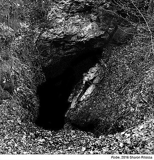
A foiba — jama in South Slavic languages scientific and colloquial vocabulary — is a type of deep natural sinkhole, doline, or sink, and is a collapsed portion of bedrock above a void. Sinks may be a sheer vertical opening into a cave, or a shallow depression of many hectares. They are common in the Karst (Carso) region shared by Italy and Slovenia, as well as in a karst of Dinaric Alps in Bosnia and Herzegovina, Montenegro and Croatia.
Raggejavreraige or Råggejávrrerájgge is a cave located in a mountain above the Hellemofjorden in the municipality of Hamarøy in Nordland county, Norway. The cave is located near the lake Råggejávrre, about 2 kilometres (1.2 mi) south of the village of Musken. Råggejávrrerájgge is a limestone cave that has been eroded by this underground river. At 580 metres (1,900 ft) deep, it is the deepest cave in Scandinavia and the only known deep cave north of the Arctic Circle.
The Trebišnjica is a river in Bosnia and Herzegovina. It used to be a sinking river, 96.5 km (60.0 mi) long above the ground. With a total length of 187 km (116 mi) above and under the ground, it is one of the longest sinking rivers in the world.
The Nambung River is a river in the Wheatbelt region of Western Australia, 170 kilometres (106 mi) north of Perth. The river drains an area between the towns of Cervantes and Badgingarra. In its lower reaches the Nambung River forms a chain of waterholes in the Nambung Wetlands where it disappears underground into a limestone karst system 5.5 kilometres (3 mi) from the Indian Ocean.
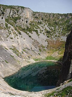
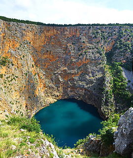
Blue Lake is a karst lake located near Imotski in southern Croatia. Like the nearby Red Lake, it lies in a deep sinkhole possibly formed by the collapse of an enormous cave. The total depth from the upper rim is around 220 metres (720 ft), while water depth varies with season. In spring, when the snow from surrounding mountains melts, it can reach 90 m (300 ft), and in 1914 it reached 114 m (374 ft), overflowing the southern rim. The lake is a popular destination for hiking and sight-seeing.

Škocjan Caves is a cave system in Slovenia. Due to its exceptional significance, Škocjan Caves was entered on UNESCO’s list of natural and cultural World Heritage Sites in 1986. International scientific circles have thus acknowledged the importance of the caves as one of the natural treasures of planet Earth. Ranking among the most important caves in the world, Škocjan Caves represents the most significant underground phenomena both on the Karst Plateau and in Slovenia. Following independence from Yugoslavia in 1991, Slovenia committed itself to actively protecting the Škocjan Caves area and established Škocjan Caves Regional Park and its managing authority, the Škocjan Caves Park Public Service Agency.

Lake Vrana, in the centre of Cres island, is a fresh water lake, 1.5 kilometres (0.93 mi) wide and about 4.8 kilometres (3.0 mi) long. The town of Cres has been supplied with drinking water from the lake since 1953, and the towns of Mali and Veli Lošinj received their supplies ten years later. It was thought at one time that the water in the lake was linked to some mainland source by underground streams, but it has since been established that in fact it originates from the atmosphere.
Hranice Abyss is the deepest flooded pit cave in the world. It is a karst sinkhole near the town of Hranice, Czech Republic. The greatest confirmed depth is 519.5 m (1,704 ft), of which 450 m (1,476 ft) is underwater. In 2020, a scientific expedition to the cave revealed that part of the system apparently reaches 1 kilometre deep, albeit with the lowest reaches sediment-filled. Analysis of the water found carbon and helium isotopes which implied that the cave has been formed by acidic waters, heated by the mantle, welling up from below.
Sanmenhai is a cave in the Leye-Fengshan geopark in Guangxi, China. The cave is unique in that it features seven skylights that mimic the layout of the constellation Ursa Major.
Little Blue Lake is a water-filled doline in the Australian state of South Australia located in the state's south-east in the locality of Mount Schank about 20 kilometres (12 mi) south of the municipal seat of Mount Gambier. It is notable locally as a swimming hole and nationally as a cave diving site. It is managed by the District Council of Grant and has been developed as a recreational and tourism venue.

Sistema Huautla is a cave system in the Sierra Mazateca mountains of the southern Mexican state of Oaxaca. As of April 2021 it was the deepest cave system in the Western Hemisphere, 1,560 metres (5,120 ft) from top to bottom, with over 55 miles of mapped passageways.

Tomaž Planina was a Slovenian cave photographer, speleologist, and botanist. He was most known for his work in cave photography, laboratory rope testing, especially in connection to knots, and his contribution to the development of the single-rope technique.

Cave diving is underwater diving in water-filled caves. The equipment used varies depending on the circumstances, and ranges from breath hold to surface supplied, but almost all cave diving is done using scuba equipment, often in specialised configurations with redundancies such as sidemount or backmounted twinset. Recreational cave diving is generally considered to be a type of technical diving due to the lack of a free surface during large parts of the dive, and often involves planned decompression stops. A distinction is made by recreational diver training agencies between cave diving and cavern diving, where cavern diving is deemed to be diving in those parts of a cave where the exit to open water can be seen by natural light. An arbitrary distance limit to the open water surface may also be specified. Despite the risks, water-filled caves attract scuba divers, cavers, and speleologists due to their often unexplored nature, and present divers with a technical diving challenge.

