Rock Island Arsenal, Illinois

Last updated

Rock Island Arsenal
USA Illinois location map.svg
Red pog.svg
Rock Island Arsenal
Location of Rock Island Arsenal within Illinois
Coordinates: 41°31′5″N90°32′13″W / 41.51806°N 90.53694°W / 41.51806; -90.53694
CountryUnited States
StateIllinois
County Rock Island County
Area
  Total2.6 sq mi (7 km2)
  Land1.6 sq mi (4 km2)
  Water1.0 sq mi (3 km2)
Population
 (2010)
  Total149
  Density57/sq mi (22/km2)
Time zone UTC-6 (CST)
  Summer (DST) UTC-5 (CDT)

Rock Island Arsenal is a census-designated place (CDP) in Rock Island County, Illinois, United States. The population was 149 at the 2010 census. [1] The island contains the Rock Island National Cemetery.

Contents

Geography

Rock Island Arsenal is located at 41°31′5″N90°32′13″W / 41.51806°N 90.53694°W / 41.51806; -90.53694 (41.518033, -90.536959). [2]

According to the United States Census Bureau, the CDP has a total area of 2.6 square miles (6.7 km2), of which 1.6 square miles (4.1 km2) is land and 1.0 square mile (2.6 km2) (37.89%) is water.

Demographics

As of the census [3] of 2000, there were 145 people, 43 households, and 40 families residing in the CDP. The population density was 90.9 inhabitants per square mile (35.1/km2). There were 43 housing units at an average density of 27.0 per square mile (10.4/km2). The racial makeup of the CDP was 62.76% White, 28.28% African American, 1.38% Native American, 3.45% from other races, and 4.14% from two or more races. Hispanic or Latino of any race were 2.76% of the population.

There were 43 households, out of which 79.1% had children under the age of 18 living with them, 88.4% were married couples living together, 4.7% had a female householder with no husband present, and 4.7% were non-families. 4.7% of all households were made up of individuals, and none had someone living alone who was 65 years of age or older. The average household size was 3.37 and the average family size was 3.46.

In the CDP, the population was spread out, with 41.4% under the age of 18, 4.1% from 18 to 24, 45.5% from 25 to 44, 9.0% from 45 to 64, . The median age was 28 years. For every 100 females, there were 93.3 males. For every 100 females age 18 and over, there were 93.2 males.

The median income for a household in the CDP was $45,417, and the median income for a family was $34,375. Males had a median income of $29,063 versus $23,125 for females. The per capita income for the CDP was $15,710. None of the population and none of the families were below the poverty line.

See also

Related Research Articles

<span class="mw-page-title-main">Rock Creek, Alabama</span> CDP in Alabama, United States

Rock Creek is a census-designated place in Jefferson County, Alabama, United States. Its location is northwest of Hueytown. At the 2020 census, the population was 1,471. This area was damaged by an F5 tornado on April 8, 1998. An EF2 tornado struck northwest from here on January 23, 2012.

<span class="mw-page-title-main">Pineland, Florida</span> Census-designated place in Florida, United States

Pineland is an unincorporated community and census-designated place (CDP) on Pine Island in Lee County, Florida, United States. The population was 466 at the 2020 census. It is part of the Cape Coral-Fort Myers, Florida Metropolitan Statistical Area.

<span class="mw-page-title-main">Fort Benning South, Georgia</span> CDP in Georgia, United States

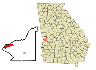
Fort Benning South is a former census-designated place (CDP) in Chattahoochee County, Georgia, United States. It is part of the Columbus, Georgia-Alabama Metropolitan Statistical Area. The population was 11,737 at the 2000 census. The area is now part of the consolidated city of Cusseta.

<span class="mw-page-title-main">Puako, Hawaii</span> Census-designated place in Hawaii, U.S.

Puako is a census-designated place (CDP) in Hawaiʻi County, Hawaii, United States. The population was 772 at the 2010 census, up from 429 at the 2000 census. The epicenter of the 2006 Kiholo Bay earthquake was some 6 miles (10 km) offshore of the village.

<span class="mw-page-title-main">Park View, Iowa</span> CDP in Iowa, USA

Park View is a census-designated place (CDP) in Scott County, Iowa, United States. The population was 2,389 at the 2010 census.

<span class="mw-page-title-main">Dames Quarter, Maryland</span> CDP in Maryland, United States

Dames Quarter is a census-designated place (CDP) in Somerset County, Maryland, United States. The population was 188 at the 2000 census. It is included in the Salisbury, Maryland-Delaware Metropolitan Statistical Area.

<span class="mw-page-title-main">Seconsett Island, Massachusetts</span> Census-designated place in Massachusetts, United States

Seconsett Island is a census-designated place (CDP) in the town of Mashpee in Barnstable County, Massachusetts, United States. The population was 100 at the 2010 census.

<span class="mw-page-title-main">Escatawpa, Mississippi</span> Census-designated place in Mississippi, United States

Escatawpa is an unincorporated community and census-designated place (CDP) in Jackson County, Mississippi, United States. It is part of the Pascagoula Metropolitan Statistical Area. The population was 3,254 at the 2020 census.

<span class="mw-page-title-main">Walton Park, New York</span> CDP in New York, United States

Walton Park is a census-designated place (CDP) in Orange County, New York, United States. As of the 2020 census, the CDP had a total population of 3,907. Walton Park is on the town line separating the towns of Chester and Monroe. Street addresses within Walton Park are usually assigned to Monroe, not Chester.

<span class="mw-page-title-main">Stone Ridge, New York</span> CDP in New York, United States

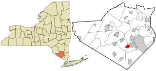
Stone Ridge is a hamlet in Ulster County, New York, United States. The population was 1,234 at the 2020 census.

<span class="mw-page-title-main">Heritage Hills, New York</span> Census-designated place in New York, United States

Heritage Hills is a hamlet (CDP) located in the town of Somers in Westchester County, New York, United States. The population was 3,975 at the 2010 census.

<span class="mw-page-title-main">Pigeon Creek, Ohio</span> CDP in Ohio, United States

Pigeon Creek is a census-designated place (CDP) in Summit County, Ohio, United States. The population was 945 at the 2000 census. It is part of the Akron metropolitan statistical area.

<span class="mw-page-title-main">Adamsville, Pennsylvania</span> Census-designated place in Pennsylvania, United States

Adamsville is a census-designated place (CDP) in Crawford County, Pennsylvania, United States. The population was 67 at the 2010 census, down from 117 in 2000.

<span class="mw-page-title-main">Brandonville, Pennsylvania</span> CDP in Pennsylvania, United States

Brandonville is a census-designated place (CDP) in East Union Township in Schuylkill County, Pennsylvania. The population was 180 at the 2020 census.

Summit Station is a census-designated place (CDP) in Schuylkill County, Pennsylvania, United States. The population is 174 as of the 2010 census.

<span class="mw-page-title-main">Colonial Pine Hills, South Dakota</span> CDP in South Dakota, United States

Colonial Pine Hills is a census-designated place (CDP) and unincorporated community in Pennington County, South Dakota, United States. The population was 1,903 at the 2020 census.

North Rock Springs is a census-designated place (CDP) in Sweetwater County, Wyoming, United States. The population was 2,207 at the 2010 census.

Washam is a census-designated place (CDP) in Sweetwater County, Wyoming, United States. The population was 51 at the 2010 census.

<span class="mw-page-title-main">Shelter Island (CDP), New York</span> Hamlet and census-designated place in New York, United States

Shelter Island is a hamlet and census-designated place (CDP) within the Town of Shelter Island in Suffolk County, New York, United States. The population was 1,333 at the 2010 census. The village of Dering Harbor and the CDP of Shelter Island Heights make up the rest of the town.

<span class="mw-page-title-main">Dixfield (CDP), Maine</span> CDP in Maine, United States

Dixfield is a census-designated place (CDP) in the town of Dixfield in Oxford County, Maine, United States. The population was 1,323 at the 2020 census.

References

  1. "U.S. Census website". U.S. Census Bureau . Retrieved March 17, 2011.
  2. "US Gazetteer files: 2010, 2000, and 1990". United States Census Bureau. February 12, 2011. Retrieved April 23, 2011.
  3. "U.S. Census website". United States Census Bureau . Retrieved January 31, 2008.