Cleveland Heights is a city in Cuyahoga County, Ohio, United States, and one of Cleveland's historical streetcar suburbs. The city's population was 45,312 at the 2020 census. As of the 2010 census, Cleveland Heights was ranked the 8th largest city by population in the Greater Cleveland area and ranked 20th in Ohio. It was founded as a village in 1903 and a city in 1921.

Shaker Heights is a city in Cuyahoga County, Ohio, United States. As of the 2020 census, the city's population was 29,439. Shaker Heights is an inner-ring streetcar suburb of Cleveland, abutting the eastern edge of the city's limits. Shaker Heights was a planned community developed by the Van Sweringen brothers, railroad moguls who envisioned the community as a suburban retreat from the industrial inner city of Cleveland.

RTA Rapid Transit is a rapid transit and light rail system owned and operated by the Greater Cleveland Regional Transit Authority (GCRTA).

University Circle is a district in the neighborhood of University on the East Side of Cleveland, Ohio. It is home to the Cleveland Museum of Art, Severance Hall, the Cleveland Institute of Art, Case Western Reserve University, the Cleveland Institute of Music, the Museum of Contemporary Art Cleveland; the Cleveland Botanical Garden; historic Lake View Cemetery; the Cleveland Museum of Natural History; and University Hospitals/Case Medical Center.

Old Brooklyn is a neighborhood on the West Side of Cleveland, Ohio, United States, located approximately five miles south of downtown Cleveland. It extends east-to-west from the Cuyahoga River to the city of Brooklyn and north-to-south from the Brookside Park Valley to the city of Parma. It is home to the Cleveland Metroparks, including the Cleveland Zoo; the Jesse Owens tree at James Ford Rhodes High School; and the Benjamin Franklin Community Garden, the largest urban community garden in Cuyahoga County. Old Brooklyn has recently adopted the slogan "Old Brooklyn, a great place to grow" to commemorate its history and potential growth.
Buckeye–Shaker is a neighborhood on the East Side of Cleveland, Ohio. It encompasses two subneighborhoods: in its south and west the old Buckeye neighborhood and in its northeast the Shaker Square neighborhood which is centered on an historic shopping district and an eponymous rapid transit station, located at the intersection of Shaker and Moreland Boulevards, on the light rail line that connects the city of Shaker Heights to downtown Cleveland. From the early to mid-20th century, the Buckeye Road neighborhood was known as Little Hungary, serving as the historic heart of Cleveland's Hungarian community, which at one time was the largest in the world outside of Hungary and for years has been almost completely African-American. Shaker Square, continues to be known as one of Cleveland's most notable neighborhoods, in terms of shopping, dining, architecture, education of its residents, participation in civic life, diversity and quality of living.

The Nature Center at Shaker Lakes is a nonprofit organization in Shaker Heights, Ohio, that works to conserve a natural area, educate visitors about nature, and promote better environmental stewardship. It was founded in 1966 as the result of a volunteer effort to preserve the Shaker Parklands from becoming the route for a new freeway connecting Cleveland's east side to Downtown Cleveland.

Forest Hill is an historic neighborhood spanning parts of Cleveland Heights and East Cleveland, Ohio, and is bordered to the north by Glynn Road, the south by Mayfield Road, by Lee Boulevard to the west and North Taylor Road to the east. Forest Hill was once the beloved summer home of oil magnate John D. Rockefeller and his family. John D. Rockefeller, Jr. purchased the estate from his father in 1923 and, with New York City architect Andrew J. Thomas, planned an upscale residential and commercial development featuring distinctive French Norman style architecture. Although the Great Depression forced Rockefeller to suspend operations, following World War II others were drawn to Forest Hill to build comfortable colonial and contemporary ranch homes on the remaining open land. Design principles of the Rockefeller-Thomas plan were extended to the later development and today Forest Hill is a rich tapestry of people, homes and gardens.

This is a list of the National Register of Historic Places listings in Cuyahoga County, Ohio.

Cuyahoga County, Ohio, United States is divided into 21 townships.

Glenville is a neighborhood on the East Side of Cleveland, Ohio. To the north, it borders the streetcar suburb of Bratenahl, the Cleveland Memorial Shoreway, and the Lake Erie shore, encompassing the Cleveland Lakefront Nature Preserve. To the east, it borders the suburb of East Cleveland, and to the south, it borders the neighborhoods of Hough and University Circle. Glenville borders the Collinwood area to the northeast at East 134th Street, and St. Clair–Superior to the west at Martin Luther King Jr. Boulevard and the Cleveland Cultural Gardens in Rockefeller Park.

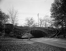
Forest Hill Park is an historic urban park that was a portion of John D. Rockefeller's estate, located in East Cleveland and Cleveland Heights, Ohio. Two-thirds of the park lie in East Cleveland, and the remaining third is in Cleveland Heights. The 248-acre (1.00 km2) park has six baseball diamonds, six lit tennis courts and walking trails that have retained the natural green space as intended by John D. Rockefeller Jr., who deeded the park to the two cities in 1936. Albert Davis Taylor was the park's landscape architect. It is the largest single body of green space between two large metroparks on the far east and west sides of Cleveland.
The Dugway Brook Watershed is a nine-square mile basin in Cleveland, Ohio and its east side suburbs, which drains storm runoff into Dugway Brook which is a direct tributary feeding into Lake Erie. Dugway Brook is one of the six greater "bluestone brooks" of Cuyahoga County, also including Dean Brook, Euclid Creek, Nine-Mile Creek, Pepper Creek, Mill Creek and Doan Brook, and their watersheds which feed Lake Erie. All of the bluestone brooks, including Dugway Brook, are located in Bluestone Heights, a unique terrain area in Northeast Ohio's place between Appalachian Highlands and Central Lowlands. At the Bluestone Heights geographic center, Lyman Circle in Shaker Heights, is the singular source point for the six greater bluestone brooks.

The Fairmount Boulevard District is a 130-acre (53 ha) historic district in Cleveland Heights, Ohio that was listed on the National Register of Historic Places in 1976.

Charles Frederick Schweinfurth was an American architect in Cleveland, Ohio. His brother Julius Schweinfurth was also an architect and they did some projects as a partnership.

North Union Shaker Site is a historic site in Shaker Heights, Ohio. The site was founded by Shakers in 1822 and was added to the National Register in 1974. The Shakers ran grist and grain mills from the lakes created when they dammed Doan Creek. The community ceased to exist in 1899. All of the buildings that had been part of the North Union Shaker community have been demolished, and 280 of the original 1,000 acres are Shaker Lakes parkland, which includes walking trails and a Shaker archaeological site, the Shaker Historical Museum and Library.

The Cleveland Cultural Gardens are a collection of public gardens located in Rockefeller Park in Cleveland, Ohio. The gardens are situated along East Boulevard & Martin Luther King Jr. Drive within the 276 acre of wooded parkland on the city's East Side. In total, there are 33 distinct gardens, each commemorating a different ethnic group whose immigrants have contributed to the heritage of the United States over the centuries, as well as Cleveland.
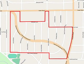
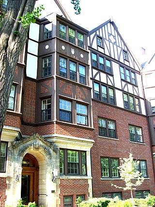
The Euclid Golf Allotment, also known as the Euclid Golf Historic District, is a historic district located in Cleveland Heights, Ohio, in the United States. Roughly bounded by Cedar Road, Coventry Road, West St. James Parkway, and Ardleigh Drive, the 142-acre (0.57 km2) site contains primarily residential homes built between 1913 and 1929. The historic district is built on land formerly owned by John D. Rockefeller and at one time leased to the Euclid Golf Club for its back nine holes, and it takes its name from this historic factoid. The Euclid Golf Allotment is a largely undisturbed example of an early 20th century planned community containing American Craftsman, Colonial Revival, French Renaissance Revival, Italian Renaissance Revival, Prairie School, Shingle Style, and Tudor Revival architecture.

The Ansel Road Apartment Buildings Historic District is a historic residential district in the Hough neighborhood of Cleveland, Ohio, in the United States. The district consists of eight contributing and one non-contributing multi-family residential buildings built between 1900 and 1949. The area was designated a National Historic District and listed on the National Register of Historic Places on July 2, 2008.