Related Research Articles

Pushmataha County is a county in the southeastern part of the U.S. state of Oklahoma. As of the 2020 census, the population was 10,812. Its county seat is Antlers.

The Kiamichi River is a river in southeastern Oklahoma, United States of America. A tributary of the Red River of the South, its headwaters rise on Pine Mountain in the Ouachita Mountains near the Arkansas border. From its source in Polk County, Arkansas, it flows approximately 177 miles (285 km) to its confluence with the Red River at Hugo, Oklahoma.
Moyers is an unincorporated community located in Pushmataha County, Oklahoma, United States.
Cloudy is an unincorporated community located in Pushmataha County, Oklahoma, United States. It is 12 miles northeast of Rattan. Cloudy is located at 34°18′07″N95°16′52″W.
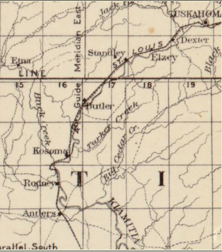
Kosoma is a ghost town and former railroad station in Pushmataha County, Oklahoma, United States. It is located just off Oklahoma State Highway 2, approximately 10 miles (16 km) north of Antlers.
Kellond is an unincorporated community and former railroad station in Pushmataha County, Oklahoma, United States. Kellond is located approximately three miles northwest of Antlers on Oklahoma State Highway 2.
Dunbar is a community in Pushmataha County, Oklahoma, United States, 17 miles north of Antlers.
Eubanks is a former community in Pushmataha County, Oklahoma, United States. It is 13 miles north of Antlers.
Honobia is an unincorporated community on the border between western LeFlore County and eastern Pushmataha County, Oklahoma, United States, 15 miles southeast of Talihina.
Jumbo is an unincorporated community in western Pushmataha County, Oklahoma, United States, 10 miles north of Miller.
Kiamichi is a former community in northern Pushmataha County, Oklahoma, United States. It is six miles east of Tuskahoma.
Miller is an unincorporated community in southwestern Pushmataha County, Oklahoma, United States. It is 10 miles northwest of Antlers and a short distance west of Moyers.
Nolia is a former community in eastern Pushmataha County, Oklahoma, United States. It is five miles east of Nashoba. Nolia is located at 34°28′35″N95°09′06″W at an elevation of 722 feet.
Rodney is a former community in Pushmataha County, Oklahoma, United States, five miles north of Antlers.
Sardis was a community in northern Pushmataha County, Oklahoma. United States. The location is six miles northwest of Clayton.
Snow is an unincorporated community in Pushmataha County, Oklahoma, United States, 18 miles northeast of Antlers.
Stanley is an unincorporated community in northern Pushmataha County, Oklahoma, United States. The community is on Oklahoma State Highway 2 seven miles southwest of Clayton. The Kiamichi River flows past the southeast side of the site.
Johns Valley is a geographic feature and place name located in the Kiamichi Mountains in northwestern Pushmataha County, Oklahoma. The valley] is formally classified by geologists as a “basin” due to its complete encirclement by mountains.
The Pushmataha County Historical Society is a historical society devoted to collecting and preserving the history of Pushmataha County, Oklahoma, United States. It is headquartered in the historic Frisco Depot in Antlers, Oklahoma, which it operates as a public museum.

The AT6 Monument is a granite memorial to Royal Air Force cadets who were killed while on a training flight during World War II. It stands on Big Mountain, north of Moyers, Oklahoma, in the United States, and was dedicated on February 20, 2000—the 57th anniversary of the deadly crashes.
References
34°17′54″N95°38′28″W / 34.29833°N 95.64111°W
| | This article about a specific stratigraphic formation in Oklahoma is a stub. You can help Wikipedia by expanding it. |