
The Arapaho are a Native American people historically living on the plains of Colorado and Wyoming. They were close allies of the Cheyenne tribe and loosely aligned with the Lakota and Dakota.

The Cheyenne are an Indigenous people of the Great Plains. Their Cheyenne language belongs to the Algonquian language family. Today, the Cheyenne people are split into two federally recognized nations: the Southern Cheyenne, who are enrolled in the Cheyenne and Arapaho Tribes in Oklahoma, and the Northern Cheyenne, who are enrolled in the Northern Cheyenne Tribe of the Northern Cheyenne Indian Reservation in Montana. The Cheyenne comprise two Native American tribes, the Só'taeo'o or Só'taétaneo'o and the Tsétsêhéstâhese. The tribes merged in the early 19th century.

The Indian Territory and the Indian Territories are terms that generally described an evolving land area set aside by the United States government for the relocation of Native Americans who held original Indian title to their land as a sovereign independent state. The tribes ceded land they occupied in exchange for land grants in 1803. The concept of an Indian Territory was an outcome of the U.S. federal government's 18th- and 19th-century policy of Indian removal. After the American Civil War (1861–1865), the policy of the U.S. government was one of assimilation.

Ellis County is a county located on the western border of the U.S. state of Oklahoma. As of the 2020 census, the population was 3,749, making it the fifth-least populous county in Oklahoma. Its county seat is Arnett.
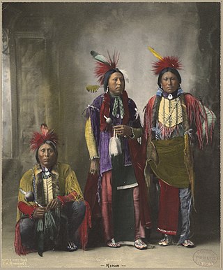
Kiowa or Ka'igwu people are a Native American tribe and an indigenous people of the Great Plains of the United States. They migrated southward from western Montana into the Rocky Mountains in Colorado in the 17th and 18th centuries, and eventually into the Southern Plains by the early 19th century. In 1867, the Kiowa were moved to a reservation in southwestern Oklahoma.
A land run or land rush was an event in which previously restricted land of the United States was opened to homestead on a first-arrival basis. Lands were opened and sold first-come or by bid, or won by lottery, or by means other than a run. The settlers, no matter how they acquired occupancy, purchased the land from the United States Land Office. For former Indian lands, the Land Office distributed the sales funds to the various tribal entities, according to previously negotiated terms. The Oklahoma Land Rush of 1889 was the most prominent of the land runs while the Land Run of 1893 was the largest. The opening of the former Kickapoo area in 1895 was the last use of a land run in the present area of Oklahoma.
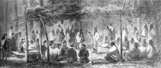
The Medicine Lodge Treaty is the overall name for three treaties signed near Medicine Lodge, Kansas, between the Federal government of the United States and southern Plains Indian tribes in October 1867, intended to bring peace to the area by relocating the Native Americans to reservations in Indian Territory and away from European-American settlement. The treaty was negotiated after investigation by the Indian Peace Commission, which in its final report in 1868 concluded that the wars had been preventable. They determined that the United States government and its representatives, including the United States Congress, had contributed to the warfare on the Great Plains by failing to fulfill their legal obligations and to treat the Native Americans with honesty.

The Territory of Colorado was an organized incorporated territory of the United States that existed from February 28, 1861, until August 1, 1876, when it was admitted to the Union as the State of Colorado.

The Dog Soldiers or Dog Men are historically one of six Cheyenne military societies. Beginning in the late 1830s, this society evolved into a separate, militaristic band that played a dominant role in Cheyenne resistance to the westward expansion of the United States in the area of present-day Kansas, Nebraska, Colorado, and Wyoming, where the Cheyenne had settled in the early nineteenth century.

The Comancheria or Comanchería was a region of New Mexico, west Texas and nearby areas occupied by the Comanche before the 1860s. Historian Pekka Hämäläinen has argued that the Comancheria formed an empire at its peak, and this view has been echoed by other non-Comanche historians.
Comanche history is the story of the Native American (Indian) tribe which lived on the Great Plains of the present-day United States. In the 17th century the Eastern Shoshone people who became known as the Comanche migrated southward from Wyoming. In the 18th and 19th centuries the Comanche became the dominant tribe on the southern Great Plains. The Comanche are often characterized as "Lords of the Plains." They presided over a large area called Comancheria which they shared with allied tribes, the Kiowa, Kiowa-Apache, Wichita, and after 1840 the southern Cheyenne and Arapaho. Comanche power and their substantial wealth depended on horses, trading, and raiding. Adroit diplomacy was also a factor in maintaining their dominance and fending off enemies for more than a century. They subsisted on the bison herds of the Plains which they hunted for food and skins.

Fort Reno is a former United States Army cavalry post west of El Reno, Oklahoma. It is named for General Jesse L. Reno, who died at the Battle of South Mountain in the American Civil War.

Southwest Oklahoma is a geographical name for the southwest portion of the state of Oklahoma, typically considered to be south of the Canadian River, extending eastward from the Texas border to a line roughly from Weatherford, to Anadarko, to Duncan. Geologically, the region is defined by a failed continental rift known as the Southern Oklahoma Aulacogen. The austere nature of the prairie landscape with intermittent island ranges has made it a favorable place for artists and photographers alike. For tourism purposes, the Oklahoma Tourism and Recreation Department has designated Southwestern Oklahoma as Great Plains Country, and defined it to consist of 14 counties including Roger Mills, Custer, Beckham, Washita, Caddo, Kiowa, Greer, Harmon, Jackson, Comanche, Tillman, Cotton, Stephens, and Jefferson counties.
Iron Jacket (Puhihwikwasu'u) was a Native American War Chief and Chief of the Comanche Indians.
The Cheyenne and Arapaho Tribes are a united, federally recognized tribe of Southern Arapaho and Southern Cheyenne people in western Oklahoma.
The Land Run of 1892 was the opening of the Cheyenne-Arapaho Reservation to settlement in the U.S. state of Oklahoma. One of seven in Oklahoma, it occurred on April 19, 1892, and opened up land that would become Blaine, Custer, Dewey, Washita, and Roger Mills counties. The land run also opened up what would become part of Ellis County, but was designated County "E" and then Day County prior to statehood.

Little Raven, also known as Hosa, was from about 1855 until his death in 1889 a principal chief of the Southern Arapaho Indians. He negotiated peace between the Southern Arapaho and Cheyenne and the Comanche, Kiowa, and Plains Apache. He also secured rights to the Cheyenne-Arapaho Reservation in Indian Territory.
John Homer Seger was an American educator best known for his work with the Arapaho tribe in Oklahoma.
The Darlington Agency was an Indian agency on the Cheyenne and Arapaho Indian Reservation prior to statehood in present-day Canadian County, Oklahoma. The agency was established in 1870. The agency established at Fort Supply the previous year was moved to a more accessible location for the tribes. Brinton Darlington, a Quaker for whom the agency was named, was the first United States Indian agent at the agency, a position he held until his death in 1872.

